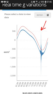
UTC time transform considering GMT time says a condition as 17:00 ~...So,understanding perfect correlation 17:33:06(UTC) information of M6.0 env Chile event👍
If NOAA dataset discusses by GMT time,position of event after Geomagnetic Storm Conditions
Ekrem Erkuş
Geophysics Engineer
UPDATE APRIL 1:
By the way,I thought necessity of sharing some informations about 'roles of Gravimetry' considering needs of some geoenvironments...
Gravimetry is the study of the measurement of gravity ("g") and its variations in time and space.
g depends on :
- Latitude;
- Mass repartition in the Earth;
- The Earth’s rotation (speed and position of the rotation axis);
- The seasons (groundwater mass variations);
- The relative position of the Moon and the Sun, which generate tidal forces.
Crustal Deformations:
Until recently, measuring vertical land movement could only be achieved using repeated levelling measurements. This was done using theodolites since the end of the XIXth century. However, it is hopeless to apply this technique to detect land movements smaller than a centimeter per year. Fortunately, for the last 20 years space geodesy allows investigating crustal deformations with an unprecedented precision. For example, it is know that the tectonic plates are generally rigid, as the deformation rates in the plate interiors are smaller than one millimeter per year. In particular, GPS and VLBI measurements showed that the relative horizontal movements between central Europe and the west side of the Rhine Graben must be smaller than 0.6 mm/an. Should they be larger, they should have been detected yet. To better assess those deformation rates, the Observatory undertook long-term projects (more than 10 years):
1 .Near the Roer Graben, continuous measurements of relative movements on both sides of the Feldbiss fault. Two GPS stations were installed in 1997, one in Bree inside the Roer Graben and on in Meeuwen, on the Campine Plateau. Presently, no detectable motion could be detected between those stations, 7.5 km from each other. The quality of the measurements is such that relative motions larger than 0.5 mm/year should have been detected. This agrees with the rates provided by the analysis of the above-mentioned European GPS networks.
2.Since 1999, we perform repeated absolute gravity measurements at eight stations across the Ardenne and the Roer Graben. This 9 km-long profile is repeated once or twice a year and should allow detecting the spatial extension of the possible vertical land movements. It will also allow distinguishing local motions from large-scale ones such as the postglacial adjustment.
Figure : The different stations where repeated absolute gravity measurements are performed. The largest observed difference in gravity in Belgium amounts about 2600 µm/s2 (or 0.00026 g). After correcting for elevation (“free air correction”) and latitude effects, 600 µm/s2 are remaining and are due to the geology (“Bouguer anomaly”).
3.In the framework of sea-level changes, gravity measurements are also performed once a year in Oostende, since 1997. This is done at the Flemish Hydrography – Coastal Division, 950 m far way from the tide gauge. Measurements are also repeated since 2009 in Saint-Amand-les-Eaux (Northern France), a collaborative project with the Regional Natural Parc Scarpe-Escaut, which is a low-lying region (elevation 20 m), quite vulnerable to climate changes.
Figure : Measuring the mean sea level is not straightforward: it is necessary to know about the stability of the benchmark. In other words, if water moves up, does the sea level increase or does the land move down? Absolute gravity measurements are a way to address this question.
Hydrological Effects:
Usually, seasonal variations are visible in the gravity measurements. Those effects are caused by the recharge of the aquifers during the winter, causing an increase in gravity at spring time, and conversely, a decrease during fall. At the Membach site, this effect is inverted, because the station is underground; consequently, the water masses are stored above the gravimeter. Hence strong increases in gravity were observed in 2006 at the end of July (dogs days) and during the sunny fall. Conversely, a strong decrease in gravity was monitored during the exceptional rainfall in August2006 and 2010, as the ground water content induces an upward Newtonian attraction.
Figure : Variations of gravity at the Membach station as monitored between January 2006 and January 2012, after correcting for tidal and atmospheric pressure effects. Note the fast decrease in gravity after the strong rainfalls in August 2006 and 2011, as well as an new increase in gravity during the sunny Fall 2006. These variations range 20-60 nm/s2, i.e. 2 to 6 billionth of gravity.
Correcting for hydrogeological effects is an active research field in Membach, Rochefort (https://www.karag.be/en/) and other reference stations in the world. It is still very difficult to correct for these effects and it requires a comprehensive hydrogeological investigation around the station, which could not be performed everywhere. However, we showed that after 10 to 20 years of repeated measurements, the hydrogeological effects should cancel out and allow determining gravity rates of changes caused by a tectonic activity, even at a level of one tenth of a billionth of g, in other words 1 nm/s2/year.
Hydrogeological effects alter geodetic measurements. Conversely, geodetic tools provide novel ways to monitor ground water masses, which remain difficult to assess. The superconducting gravimeter of Rochefort was installed for that purpose (https://www.karag.be/en/).
At this point, I think necessity of establishing add informations about Solar Phi Angle(IMF Polar Angle);
http://mysolaralerts.blogspot.com/p/what-is-solar-phi-angle.html?m=1


Geocentric Solar Magnetospheric Coordinate System is a Polar Coordinate System.You are right,we can say catched of approximately 315° levels after a deviation by very short timeframe as orthogonal👍
YanıtlaSil