Kayıtlar

Ağustos, 2019 tarihine ait yayınlar gösteriliyor

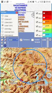
A source province explains by geologist environments at Antalya region..This condition have confirmed!!!

Resim
Antalya as origin is as a Turkish transliteration from Attaleia.Settlement date expresses as 158 BC by Pergamon King_Attalos II.   https://www.wikizeroo.org/index.php?q=aHR0cHM6Ly9lbi53aWtpcGVkaWEub3JnL3dpa2kvQXR0YWx1c19JSV9QaGlsYWRlbHBodXM A source province explains by geologist environments at Antalya region.Presence of this condition have detected during my analysis;

Bingöl Triple Juction Region_A source province as geologic

Resim
There are some explanations of Geology environments about a Geologic Province as near at Central Bingol.I confirmed this condition during my analysis.Characterised with Bingöl Triple Juction as Location and supplied with Geomorphologic structure.Data informations;

Rhodope Province_A Focalpoint as Geologic

Resim
I know some informations  about expressed among focalpoints as Geologic of Rhodope Region; And,Seismology data are confirming to expressions about Rhodope as Geologic; So,above frame by Electroquake thesis is understanding as  a Geologic source province.Some other informative sources are other suppliers;   https://www.wikizeroo.org/index.php?q=aHR0cHM6Ly9lbi5tLndpa2lwZWRpYS5vcmcvd2lraS9SaG9kb3BlX01vdW50YWlucw https://www.sciencedirect.com/science/article/abs/pii/S1342937X14002640

I realised a analysis which based on M6.3 Aug 29,2019...

Resim
I realised a analysis which based on M6.3 Aug 29,2019...You are right!!!I will follow to Earthquake and any volcanism event projection into a short time range  by this event.Also,I show to description of two Geophysical Province with Earthquakes by dayscale at Map.Note.Big circles are expressing to my focalised routes; By the way,I know YASUR SULPHURE VOLCANISM  into latest times at first Geophysical Province; FOR AUG 30,BRASIL EVENT(M4.6) WHICH EXPRESS AS EXTRAORDINARY AS LOCATION; So,I mean that this location is not a mystery...I waited for a big magnitude event for Aug 30.But,realised a location event as very extraordinary !!! That this location is on my redcircle; So,I summary that about established a solution of this technique for location events as very extraordinary  I catched to two corelated M5.0 environment event based on yellow circle by latest developments; Note:I catch a conclusion as quite interesting as ~10000km among

A method suggestion as very powerful

Resim
I think that We can produce to precious informations about Geophysical Source Points with predictions about our Earth by Elektroearthquake concept...In this concept,I considered a analysis; Where,my reference is M6.8 S SANDWICH EVENT(AUG 27,2019).Conclusions are perfect!!! Firstly,My Geophysical Source Discoveries; Location1,over Ninetyeast Ridge PROVINCE Location2,over French Polynesia_ATOLL PROVINCE And,some snapshots about circle environemnts which characterised with latest Earthquakes&Volcanic Events; Thus,not only Earthquake Prediction or events as Volcanic Explosion also for Geophysical Source PROVINCES  thus I can express a considerable method Thanks... Ekrem

Çavdarhisar(Ancient Aizanoi) File

Resim
Earthquake Reality of Çavdarhisar Region expresses via audiovisual media.This reality have confirmed during my analysis!!!As quite weird ,I observe to condition as inner province(subprovince) of a outer province;  So,quite exrtraordinary condition!!!I reached some informations about only 1970 Earthquake event by audiovisual sources; https://turkisharchaeonews.net/site/aizanoi https://www.flickr.com/photos/feridun_f_alkaya/26542865289 But,realised of quite Catastrophic Earhquakes at ancient times is fixing based on some informations.Thus,I can express as a important station for Archaeogeophysical explorations on World

about Mt.Davis File

Resim
This type geologic morphologies are not extraordinary by my experiments...Yes,you are right!!!Mt.Davis province as conlusion of my analysis have solutioned; This province is into a national monument statue...And,for other realities; https://tpwd.texas.gov/state-parks/davis-mountains/nature http://travellogs.us/2007Logs/Texas 2007/23-west TX-Balmorhea/23f Geology Davis Mountains.htm

Rincón Viejo Province_confirmation to Electroquake Thesis which based on some mostra characteristics

Resim
Rincón Viejo Province during my analysis have identified based on epecially surface mostra specifications that this condition is confirming  to Electroquake Thesis; Surface mostra Informations are as indicator of Metalic a Province  based on colour characteristics;

Sinanpaşa Province/Afyonkarahisar is not a mystery

Resim
Sinanpaşa Province/Afyonkarahisar is among expressed other provinces as very powerful of Electroquake thesis.So,some explanations about province is not mystery.Shortly,I confirm by analysis conclusions;

Alpu Province_A focalpoint as Geologic!!!

Resim
Expressed some explanations about Alpu region are causing to some focalising conditions to this region.Electroquake thesis as supplementary to some geologic informations confirming  to this explanations;

Other confirmative example to thesis  based on electroquake

Resim
Other confirmative example to thesis  based on electroquake; Where,central province show to Mt.Spil National Park of Magnesia or Manisa  as Turkish transliterated as well-knowed; 

Established solution_origin of Beyşehir&Eğirdir lakes is not a mystery

Resim
Identified other example  as Geologic Structure at Turkey; Location analysis show a circle patern morphology; Dedegöl Mountains  into Province are characteristics...Also,Aksu settlement as province centre can express.Also,I think a important supply to public about how a origin as background of especially Beyşehir&Eğirdir lakes 

10000km distance rule a orthogonal effect have explained!!!

Resim
A issue among most wondered chapters of Google Earth users is subject.Orthogonality problem at reference point of second circle for maximum circle drawings as 10000km radius with circle option via ruler option!!!This explanation paper not only for this problem also about establishing to how 10000km distance route  a orthogonal point thus good information will present...User with this explanation; Role of Quarter Route Using as 10000km distance A good information about how efficiently using to circle option with Produced Quarter Route will learn Also,explanation will light to users for some applications... Firstly,schematic expression which will be a reference for application steps;       Application: My focal point is (30S,140E) Thus, (360-140)/140=~1.571 Beta=arctan(1.571)=57.5 degree (180-(-30))/(-30)=-7 Alfa=arctan(-7)=-81.8 degree means 81.8 degree as trigonometric Firstly,pining to focal point at Google Earth; Important Note:Where,expresse