Kayıtlar

Nisan, 2023 tarihine ait yayınlar gösteriliyor

New Generation HLEM Systems

Resim
 

Coordinate Informations 4/27

Karangetang News

Resim
  The Pusat Vulkanologi dan Mitigasi Bencana Geologi (PVMBG) announced that the effusive eruption at the volcano has stopped or at least has decreased its activity. Since 1 April, visual observations confirm neither lava flows nor glowing lava blocks from the lava dome within the southerly located Crater 1. However, a visible near-constant glow is being monitored from Crater 2, oriented north. Passive emissions of steam and gas continue to emit from craters rising approx. 200 meters above the volcano. The seismic activity has waned simultaneously with the diminished effusive activity. During 1-25 April, the monitoring station recorded about 130 hybrid earthquakes, 76 shallow earthquakes, 19 deep earthquakes and 15 volcano-tectonic tremor events. Hence, a decision has been made to lower the alert level for the volcano to Level 2. In order to risk mitigation, people are not allowed to approach the Main crater area (south) within a 1.5 km radius and the North crater area within a 2.5 km r

Ahyi Volcano News

Resim
  The Northern Mariana Islands Volcano Observatory announced that the ongoing seismic unrest at the volcano has reduced over the past four weeks. Since late-March-mid-April, no particular and significant signs of hydroacoustic detection nor discoloured water have been registered. Therefore, the volcano observatory declined the alert level to "Unassigned". The activity of the undersea volcano continued to be elevated since mid-October last year as hydroacoustic sensors at Wake Island, located 2,270 km (1,410 miles) east of the volcano, began to register signals consistent with activity from the undersea volcanic source. The plume of discoloured water above Ahyi undersea volcano has been visible constantly in satellite data since 18 November. Source: Northern Mariana Islands Volcano Observatory volcano activity update 26 April 2023

Reported Selective Differentiation for Globe Seismic Activity

Resim
 

Documented Geomagnetic Storm Conditions

Resim
 

Coordinate Informations 4/26

Reported Selective Differentiation for Globe Seismic Activity

Resim
 

Coordinate Informations 4/25

Reported Selective Differentiation for Globe Seismic Activity

Resim
 

Documented Geomagnetic Storm Conditions

Resim
 

Coordinate Informations Apr24

Sangay News

Resim
Sun,23 Apr 2023   Two stronger-than-usual eruptions occurred at the volcano over the past few hours. Dense ash emissions rose about 26,000 ft (8,000 m) above the summit crater and drifted to the southwest of the volcano where tephra covered surfaces in the province of Chimborazo (Guamote, Cebadas and Matriz).) Most of the ejected hot, juvenile and glowing material slid down along the southeastern flank in the form of incandescent avalanches. Satellite-based measurements of SO2 concentrations were detected in plumes of about 495 tonnes on 21 April. Explosions were a few times stronger than the average size of explosions at the volcano and such events are nothing unusual on the volcano and occur from time to time. Source: Instituto Geofísico volcano activity update 23 April 2023

Rincon de la Vieja News

Resim
Date:Sat,22 Apr 2023 A powerful phreatic explosion took place at the volcano yesterday. The eruption was strong enough to produce a dilute pumice-and-ash flow due to a culmination of a billowing white-to-grey dense ash plume. The pyroclastic flow traveled over the northern flank and reached length of at least 2 km from the summit, a local observer reported. The height of the ash column is unknown and was reported yet neither by the observatory nor the VAAC. People are advised to avoid the area in the north.  https://m.facebook.com/volcanessinfronteras/videos/3441012802831283/

Piton de la Fournaise News

Resim
 Date:Sat,22 Apr 2023 Seismic recordings of the Observatoire Volcanologique du Piton de la Fournaise (OVPF) detected a seismic crisis at 03:11 pm local time yesterday, typical sign of magma pushing its way towards the surface. This evolving seismic activity lasted only by 04:20 pm local time as it ceased, but only to restart to rise into deeper rock layers again, the volcano observatory reported. Several volcano-tectonic earthquakes were located beneath the southern rim of the Dolomieu crater. Volcanologists expect an eruption to occur within a few hours or so. Source: Observatoire Volcanologique du Piton de la Fournaise volcano activity

Reported Selective Differentiation for Globe Seismic Activity

Resim
 

Documented Geomagnetic Storm Conditions

Resim
 

Reported Selective Differentiation for Globe Seismic Activity

Resim
 

Coordinate Informations Apr19

Documented Geomagnetic Storm Conditions

Resim
 

Reported Selective Differentiation for Globe Seismic Activity

Resim
 

Coordinate Informations Apr18

Reported Selective Differentiation for Globe Seismic Activity

Resim
 

Documented Geomagnetic Storm Conditions

Resim
 

Developments of Havre Seamount Geography !!!

Understanding clearly selective developments for Havre Seamount Geography with Apr11 especially😐(So,I cite MeWe platform data of 11,12,13,15,16 and today👍) Developments of region are following... Be safe everyone Ekrem Erkuş Geophysics Engineer

Analysis Conclusions Apr17

Reported Selective Differentiation for Globe Seismic Activity

Resim
 

Reported Selective Differentiation for Globe Seismic Activity

Resim
 

Aniakchak Developments!

Resim
  The Alaska Volcano Observatory (AVO) announced that an increased rate of seismic activity at the volcano has been registered in mid-February, following the ongoing earthquake swarm from October 2022. Ever since, quakes have become more intense and shallower at less than 5.6 miles (9 km) depth. Later on, in mid-February, earthquakes have continued to pick up  in numbers per day including a maximum magnitude M 3.3 on 17 February. Transmissions of seismic records were disturbed due to a network outage in early March causing an inability to detect small earthquakes. However, the seismicity remains above background levels. The evolving activity was found in the strongest quake with a magnitude of 3.3 on 6 April. Earthquakes and ground uplift (inflation) likely reflect magma injections and migration beneath Aniakchak caldera at depths between 2 to 2.5 miles (3 to 4 km). These shallow magma levels may indicate tell-tale sign of an impending eruption. Therefore, a decision has been made to r

Reported Selective Differentiation for Globe Seismic Activity

Resim
 

Predicted M6.5 env Javasea Event!!!

Resim
A focus region after M5.5 env(Floressea) event of Apr3!!!(So,already drawed attention by routine observers based on some developments to  Floresea Geography😐)   And next,we witness for JavaSea Geography a M6.5 env event after MeWe platform information of Apr7😐 Ekrem Erkuş Geophysics Engineer/TURKEY

Documented Geomagnetic Storm Conditions

Resim
 

Coordinate Informations Apr14

Reported Selective Differentiation for Globe Seismic Activity

Resim
 

Coordinate Informations Apr13

Reported Selective Differentiation for Globe Seismic Activity

Resim
 

Documented Geomagnetic Storm Conditions

Resim
 

Coordinate Informations Apr12

Reported Selective Differentiation for Globe Seismic Activity

Resim
 

Shiveluch News

Resim
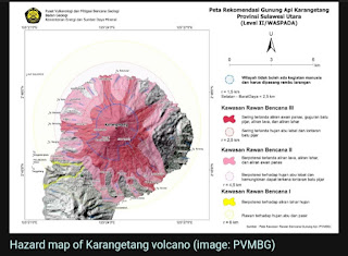
  A major eruption took place at the volcano this morning at about 08:30 local time. The sizeable explosion created a spectacular grey ash-rich eruption column which reached up to 52,000 ft (15,800 m) altitude and drifted about 340 km to the north-northwest and about 240 km to the west-southwest of the volcano. Its sound was heard in Klyuchi village and the sky is dark of ash, local volcanologists reported. Soon after the eruption, a heavy fall of grey ash fine particles affected all surfaces, including urban areas. The local ground is being covered by a thick ash tephra blanket with a width of about 6-8 cm. The eruption culminated in a massive and dilute pyroclastic flow as well, scooting across the vast edifice area. Whether the powerful explosion destroyed the actively growing lava dome area is not clear yet, we might to conclude it later on from upcoming taken images or satellite images. A huge amount of fine ash particles, released from the eruption, might present a danger for avi