Kayıtlar

Ocak, 2024 tarihine ait yayınlar gösteriliyor

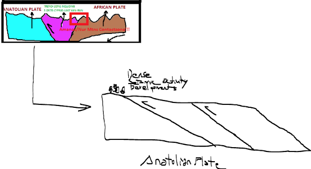
Google Earth Circle Tool-example about principle of an orthogonal analysis based on selective geologic element

Resim
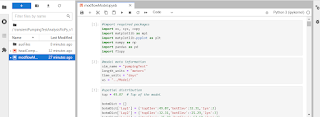
  Where,main chapter that carrying-out  "perfect determination" based on x and y axes of your focus geologic element😐After this step, very very easy via Google Earth Pro determining (lat1,lon1) and (lat2,lon2) points referencing x and y axes!In this field,I experienced various working type😐I recommend approach to users among "most applicable solutions" of geologic information concept👍 For presentation supplementary to explanation;

Merapi Developments

Resim
  A strong eruption occurred at the volcano yesterday afternoon. At around 12:54 local time, a large hot avalanche, known as pyroclastic flow, descended from the active lava dome at the summit crater. The extremely dangerous, fast-moving turbulent flow consists of a mixture of hot rock fragments of the lava dome, volcanic gasses and ambient air. It traveled through the Kali Boyong ravine on the southern flank and reached the usual distance of about several hundred meters from the summit. It also produced massive grey ash-abundant plumes, so-called phoenix clouds, separating from the block-and-ash flow. Pyroclastic flows are typically formed when the accumulated lava masses at the summit crater, known as the lava dome, become too large and suffer smaller or larger gravitational collapse, which then turn into fast and deadly avalanches as they destroy and burn everything in their path. The alert status remains at Level 3 since 5 November 2020. The public is being warned to stay at least

My explanations considering needs of some envs in light of actual developments

Resim
  I approbate informing via a schematic presentation to developments on neartime frame considering some information deficiencies about asteroid transitions; I hope to satisfying role some needs of short but clear informations

A Geometric Analysis after Brasil Geography Seismic Phenomena

 M4.8-W of Qaraçala,Jan19 M5.6-ESE of Cartago,Jan19 M4.3-S of Saint-Pierre,Jan12 M5.1-SE Central Pacific Ocean,Jan17 M5.0-NE of Hihifo,Jan18 M4.2-W of San Antonio de los Cobres,Jan14 M5.2-WNW of Ollague,Jan14 M4.3-ENE of Zapatoca,Jan15 M5.1-Bouvet Isl Region,Jan15 M5.7-S Sandwich Isls Region,Jan18 M5.2-W of Cepita,Jan21 M4.2-SSW of La Gomera,Jan14 M5.0-E of SantaMaria Zapotitlan,Jan18 M4.2-WSW of Acajutla,Jan19 M5.5-WNW of Sola,Jan19 M4.4-WSW of Guadalupe Victoria,Jan20 M4.3-S of Saint-Pierre,Jan12 M5.1-SE Central Pacific Ocean,Jan17 M5.0-NE of Hihifo,Jan18 M5.1-NNW of Isangel,Jan15 M4.3-SSE of Isangel,Jan15 M4.9-NW of Isangel,Jan19 M4.7-SE of the Loyalty Isls,Jan19 M4.3-SE of the Loyalty Isls,Jan19 M4.8-NW of Tuti,Jan19 M5.2-ESE of Vao,Jan20 M4.4-SW of Palca,Jan21 M4.3-S of Saint-Pierre,Jan12 M4.8-NW of AntofagastadelaSierra,Jan15 M4.1-WSW of SanPedrodeAtacama,Jan15 M4.1-NE of Çelikhan,Jan18 M5.3-S Sandwich Isls Region,Jan18 M4.3-NNE of Gürün,Jan19 M5.0-"          "        &

Sensitivity Analysis-Pumping Test

Resim
  Datalink: https://www.youtube.com/watch?v=Tsc-gNlsli8&t=2452s

A geometric anaysis of neartime after China's Border Geography Seismic Phenomena

M5.2,Jan15-NW of Kurumkan/RUS M4.4,Jan15-SSE of Chignik/ALS M4.1,Jan18-SSW of Taloqan/AFG M4.4,Jan15-S of San Clemente Isl M4.1,Jan16-SSE of Adak M4.5,Jan21-SE of QarahBagh,AFG M4.9,Jan21-E of Petropavlovsk,RUS M4.1,Jan13-ENE of Edmond/US M4.5,Jan19-DC Congo M5.3,Jan19-SW of Salcha/ALS M4.4,Jan15-SSE of Chignik/ALS M4.7,Jan15-Kermadec Isls Region M4.3,Jan15-Kermadec Isls Region M5.1,Jan15-Kermadec Isls M4.5,Jan16-NE Teller/ALS M4.3,Jan16-SSW of Padam/IND M4.1,Jan12-NE of Dipayal/NEPAL M4.4,Jan14-SWestern Tonga M4.1,Jan17-off the west coast of Northern Sumatra S Tonga Events(Jan12-M5.4,Jan14-M4.5,Jan15-M4.8,Jan15-M5.0,Jan17-M4.9)  

A geometric anaysis of neartime after Japan Seismic Phenomena

  12/26-M4.6 Papua Region 12/27-  M5.0 M5.1 Reykjanes Ridge 12/30-M4.6 Central East Pacific Rise 12/26-M4.7  Yemen Triple Junction Region 12/29-M5.0 Myitkyina Region 12/29-M4.7 Mid-Indian Ridge 12/29-M5.1 Chagos Archipelago Region 12/29-M4.7    "                 "                " 12/29-M5.2 Mid-Indian Ridge 12/29-M5.7        "              " 12/29-M5.0 Chagos Archipelago Region 12/30-M4.5 Shimukkapu Region   12/30-M5.7 W Sumatra 12/27 M4.5 Akutan Region 12/28 M5.8 Pacific-Antarctic Ridge 12/28 N of Almeria/PHI 12/28 M4.5 Amagi Region 12/29 M4.6 Balleny Isls Region 12/30 SW of Silanga/PHI 12/31 M4.8 Amagi Region

Merapi News

Resim
  A massive eruption occurred at the volcano shortly after noon yesterday. At around 13:55 local time, a very large glowing avalanche, known as pyroclastic flow, descended from the active lava dome at the summit crater. The extremely dangerous, fast-moving turbulent flow consists of a mixture of hot rock fragments of the lava dome, volcanic gasses and ambient air. It traveled through the Bebeng/Krasak ravine on the southeastern flank and reached a distance of estimated several km from the summit, meaning close to populated areas. It also produced massive ash plumes that affected much of the southern flank and caused panic in some villages. There are no reports of fatalities or injuries at the moment although information is yet incomplete from what might have happened in the areas hit by the flow. Pyroclastic flows are typically formed when the accumulated lava masses at the summit crater, known as the lava dome, become too large and suffer smaller or larger gravitational collapse, whic

My explanations after seismic news of Argosbay region

Resim
 We witnessed to seismic news as deep&big magnitude for Argosbay region after developments of Kos island region.Evaluations as a whole are related to backzone of active volcanic arc;

Coastal Silifke(SWestern) Seismic Developments

Resim
  We can express Coastal Silifke(SWestern) as another region observed of dense seismic activity developments referencing small magnitude events at Turkey Geography.I executed eventually an explanation about region seismic events as a conclusion of individual working efforts.Where,I cite especially to "Important Tectonic Components of Turkey Geography based on Anatolian Plate" among myblog sharings; Yes,as evaluated,we are understanding clearly caused to important effects for either trench zone and southern part of Anatolian Plate of dominant horizontal pressure effects by African Plate👍You are right,thus,witnessing to dense seismic activity developments related region of Coastal Turkey Geography with thrusting type tectonism for Anatolian Plate. Ekrem Erkuş Geophysics Engineer

Some explanations for pumping test on a confined aquifer among Clairborne aquifer wellsite experiments

Resim
 Where,you  will obtain some informations about structure based on Python script with Flopy package; Note. I predict consciousness based on file strucutres of some folders of related envs.With this,I recommend harshly review pdf files of dowload folder for some envs😐 Datalink: https://hatarilabs.com/ih-en/groundwater-modeling-of-a-pumping-test-over-a-confined-aquifer-with-modflow-6-and-flopy-tutorial

Installation of gemgis module and example application of a transform to vtk files based on leapfrog mesh files(msh)

Resim
Clear informations about installation of gemgis module; Application; Paraview Transform Conclusions; Data Link; https://hatarilabs.com/ih-en/convert-geological-units-from-leapfrog-msh-to-vtk-using-python-and-gemgis-tutorial