Explanations aiming a awareness to public about actual seismic news at Turkey Geography.Also,I expressed clearly some realities of Turkey Geopgraphy!!!
I continue to producing a awareness to public on 'individual efforts completely' at Turkey Geography.Thus,I summaried satisfying informations against to some needs by actual data;
- NEastern Erzincan-SWestern Bayburt events>NEAFZ
- E Ulaş-N Kangal events>tectonic zone related of Sub-part including Southern Sivas of Anatolia Microplate
- E Mut events >Tectonic Arc of SWestern Malatya-Isparta(evaluating as thick a zone relatively!As summary,Eastern and SEastern seismic events of Antalya Settlement include this tectonic arc stru)
Ekrem Erkuş
Geophysics Engineer
Especially,I sign a cond very very weird about sensing matters based on their realities as geography of native region peoples!You are right!At this point,I imply a supplementary&complementary cond to native region peoples of this type informations👍
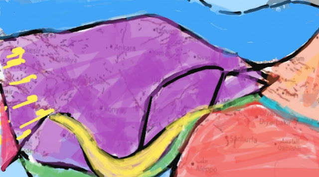
By the way, Subject dense map requests among inforequests of native region peoples!!!I share to attention of envs related satisfying a map these needs;
I remembered selective some events on neartimeframe relatively as related to Sub-Part including S of Sivas of Anatolia Microplate;
》Niğde Fault Zone Seismic Events
》Sarıoğlan Province Seismic Events
》Kangal Region Seismic Events
》Arguvan Region Seismic Events
You are right!We say to perfect correlation to sub-part expressing of these events👍
Also,You will inform about routine seismicity events including SW of Silifke👍
Yes,summaried as yellow tectonic arc stru expressing on E Mut events👍
Green arc stru is zone including Cyprus Isl as a whole👍
Yellow arrows summary opening cond of Aegean Plate👍
IMPORTANT NOTE.You are right!understanding a weird cond based on Anatolia Microplate for SW Turkey Part...summarying powerly dev expressing as "Dynamic Intraplate Tectonism" for this cond😐Yes,in this mean,I cite on needs of some geoenvironments to yellow tectonic arc👍🙏✋


This map information can express as conclusion of important a observation progress....Thus,I say clearly big supply various geoenv of main tectonic frame stru!!!!!!!
YanıtlaSilBut,If you use to Google Earth,you must know some pre-conditions about image thrusting function
SilSo,you must consider a shifting cond by extension!!!
SilWhere,you will witness perfect infrmtns related to collision zones of Arabian Plate with catching morphologies summarying perfect correlation to subparts of Anatolian Plate!!!!!!
Sil