Hunga Tonga-Hunga Ha'apai Volcano


An intense powerful explosion took place from the volcano at around 20:30 local time today as reported Volcanic Ash Advisory Center (VAAC) Wellington.
A spectacular ash plume rose several kilometers above the summit and given the submarine volcano's summit elevation (149 m), the eruption sent a tall ash cloud up to 15 km (50,000 ft) altitude.Sentinel-5 and TROPOMI satellite-based measurements of SO2 concentrations in the atmosphere detected about 9 kilotons extended to the north of the volcano.
The loud explosion at the uninhabited island was heard about 170 km away from nearby islands as reported in social media.
From available satellite images and pictures, the presence of water is likely causing significant explosive interaction (phreatomagmatic activity) of water and magma.
12/23 Update:

A breathtaking view occurred eyewitness at the boat floating while the major eruption at the volcano on 20 December. During the explosion a base surge was generated, a common feature of many phreatomagmatic (hydromagmatic) eruptions. Pyroclastic cloud consisting of ash and steam is formed in a ring around the base of the eruption column.
A high-resolution satellite image of the eruption was captured by the MAXAR satellite as attached below.
Observers at the boat while the eruption (source: @alakihihifo/twitter)
A high-resolution satellite image of the eruption was captured by the MAXAR satellite as attached below.
Observers at the boat while the eruption (source: @alakihihifo/twitter)

12/30 Update:

The explosive eruption of the volcano continues characterized by dark and dense masses of pyroclastic material and ground-hugging currents known as base surges, typical signs of surtseyan and phreatomagmatic eruptions.
Another spectacular footage has been recorded by eyewitnesses from the boat floating while eruption on 28 December.
The powerful blast ejected rocket-like fragments, as seen from a distance, arcing upwards along parabolic paths known as cypressoid or cock's tail effect.
Another spectacular footage has been recorded by eyewitnesses from the boat floating while eruption on 28 December.
The powerful blast ejected rocket-like fragments, as seen from a distance, arcing upwards along parabolic paths known as cypressoid or cock's tail effect.
Update 31/12:
Video of catastrophic explosion!!!
https://youtu.be/BX97MIXPhkk
Update 4/1:

A new satellite image of the volcano from 2 January was captured with significant morphological changes that have formed during the latest phreatomagmatic activity.
From available satellite images, it seems to confirm a new cone compared to the most previous imagery from 3 December.
The new cone has likely formed by the accumulation of tephra around the vent and is located to the northeast from the previous 2014-2015 cone, already eroded by currents and waves.
From available satellite images, it seems to confirm a new cone compared to the most previous imagery from 3 December.
The new cone has likely formed by the accumulation of tephra around the vent and is located to the northeast from the previous 2014-2015 cone, already eroded by currents and waves.
Update 1/14:
https://youtu.be/zxZ3dmeI7wY
Update 1/15:


After almost two weeks calmperiod, the activity has picked up again with a high phreatomagmatic eruptive phase.
A spectacular explosion occurred at 15:14 UTC yesterday characterized by dark and dense masses of pyroclastic material and ground-hugging currents known as base surges, typical signs of surtseyan and phreatomagmatic eruptions. An increasingly larger and dense plume sent ash up to 55,000 ft (17,000 m) altitude. Note gravity waves rippling across umbrella region in the plume as can be seen in the satellite animation.
According to available sources, 86 000 volcanic lightnings were detected in the eruption column. Such volcanic "thunderstorms" are often seen during explosive eruptions producing large quantities of ash, although the details are still poorly understood. In a simplified model, the lightnings are the result of electric charges accumulating in different parts of the eruption cloud, where friction between the ash grains rip of electric charges (electrons) from each other. The more quantity of ash emitted, the faster and more turbulent it is moving and the finer the ash grains, the more likely this process occurs.
Update 1/16:


The tsunami, generated by the violent eruption today, has been traveling across vast stretches in the Pacific Ocean.
After almost 11 hours since the eruption started, the waves, about 3 ft (1 m) tall, hit the part of the west coast of the United States such as Santa Cruz, CA and the Oregon coast.
In about 1 hour later, waves (4.6 ft (1.4 m) have reached the coast of Mexico in Manzanillo port.
The tsunami was large enough to be felt on Hawai'i about 3,100 miles (5,000 km) away from the eruption site.
Elevated sea level has been reported in Ecuador.
Several dozen seismic stations of volcanological observatories detected the pressure wave from the eruption. Seismic signals of the shockwave were reported in Iceland, Canary Islands, Netherland, Alaska and USA.
As to what exactly caused the massive ocean wave and whether a collapse of the island, whether turbidity currents triggered, or whether the force of the explosion itself, is not clear yet, but the most likely scenario is the last option.


Recent satellite images show dramatic and significant morphological changes in the volcano's shape during the recent activity. Judging from the latest image after today's massive eruption (16 January) and comparing to previous images from 17 November and 7 January, it seems that most of the island is destroyed.
A presentation lighting about Shockwaves;
https://spaceweathergallery.com/indiv_upload.php?upload_id=181596
UPDATE 1/17:


According to the Ozone Mapping and Profiler Suite (OMPS) lidar-based satellite, measuring the global distribution of ozone as a remote sensing method, it seems the eruption column height has been measured up to 30 km meaning that reached the stratosphere level.
The TROPOMI satellite-based measurements of SO2 concentrations in the atmosphere detected the total mass of about 400000 tonnes - not enough for climate impacts - in the impressive SO2 plume ejected by the volcano on 15 January. Aerosol plumes (mostly tiny droplets of sulphuric acid in the stratosphere, as well as some very fine ash particles) have been traveling along vast stretches in the southern hemisphere.
The TROPOMI satellite-based measurements of SO2 concentrations in the atmosphere detected the total mass of about 400000 tonnes - not enough for climate impacts - in the impressive SO2 plume ejected by the volcano on 15 January. Aerosol plumes (mostly tiny droplets of sulphuric acid in the stratosphere, as well as some very fine ash particles) have been traveling along vast stretches in the southern hemisphere.

The attached image contains infrasound records from three Cascade volcanoes. Red box is initial airwave from Tonga eruption. Gold box is the airwave as it came around on it's second lap.
Source: United States Geological Survey volcano activity update 16 January 2022
An impressive video of Himawari-8 satellite sensor that captured the pressure wave on 15 January traveling across the globe (source: @TransTerraScape/twitter)


So far, 41 buildings have fallen victim to the tsunami and 63 were found covered by ash in Nomuka village caused by the latest violent eruption.
Ash-and-tsunami affected populated areas detected by the satellite were also recorded in Nukuʻalofa, the capital of Tonga, Fafaa village and Pangai town.


The volcano has been eroded to two very small remnants of origin islands Hunga Ha'apai (left) and Hunga Tonga (right).
The 2015 cone (centered between islands) is completely destroyed.
Large amounts of floating pumice (light brown) are visible in the image.
The latest Himawari-8 satellite visualization of SO2 concentrations in the atmosphere shows the SO2 eruption plume that has been advancing towards eastern Africa coming from Australia over the past few days.

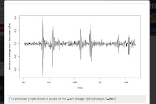
An attached pressure diagram depicts 6 pressure peaks rather than 3 because the wave arrives twice, both from N-NW and from S-SE with 10-hours delay between the peaks as informed Dr. Evgenia Ilyinskaya, the researcher of Leeds University.


Yorumlar
Yorum Gönder