New Generation Technologic Developments will cause to what type developments?
Especially,Geophysics technics based on water sources express into wide range...In this mean,various charts presented based on geophysics methods are informing on advantages/disadvantages of methods.
Subject some chapters for technics on manmade source impact;
- Logistics
- Equipment
- Quantity of person
- Timerange of data collection
that among important headlines!!!
Thus,Acoustic Resonance Profiling Technique increases to "Number 1"position to system by chapters expressed on considering to development progress since 90s
So,for example;
- Developments considered as depth&resolution via non-destructive source impact established
- Advantages as equipment&logistics with one person
- Time advantage for data collecting at wide areas
- Advantage of method against to electric/electromagnetic interference type effects(expressing performance of method based on electric/electromagnetic type noise conditions)
You are right!!!As evaluated,emphasizing to various advantages based on data collecting chapters of a field as individual
As Conclusion:
Subject some disadvantages caused of measurement concept via any authorities or any administrative decisions!!!In this mean,I especially sign to chapter as carrying-out of unbiased reports on advantages caused of system
Clearly understanding a big development condition for private sector field of this chapter
I especially will wait for ideas of Geophysicists&related Geoenvironments about this chapter
Again thanks...
Ekrem Erkuş
Geophysics Engineer
Yes.As evaluated,I especially emphasize to established important development based on applications considered for various field with causing to important a development on independent inspection&independent inspector chapters based on geologic firms related of this condition.
Also,I established a job flowchart model generalised for firms about independent inspection chapter expressed based on Acoustic Resonance Profiling technique;
Also,I established a job flowchart model generalised for firms about independent inspection chapter expressed based on Acoustic Resonance Profiling technique;

Where,I especially underline that role of big impulse established to unbiased introduction webpages of Geophysicists considering "pratic and effective conclusions" of ARP technique!!!! So,a Geophysicist with this system is not under any constraints about data collecting chapter.Independent data collecting condition of a Geophysicist for everytime&everywhere is always subject on system principles.Thus,unbiased introduction webpage chapter will be a focus based on extreme effficient and dynamic structure.
I will wait for replies of especially Geoenvironments
By the way,I will sign to routine problems of some Geoservice firms.Constraints expressed of some Geophysics systems are directing to completing via dbase of requesters dbase weakness of some Geoservice firms!!!You are right!!!Conditions as some legal rights with this condition are subject.In this mean,system has to great advantages.
And,I present links for informing detailed:
Some examples of the results
http://vodopoisk.geoacoustic.com/primer.html
References
http://vodopoisk.geoacoustic.com/ssylki.htmlBy the way,this system is handling under operation structure of Federal Region Companies designed on technologies produced of central research institute(Moscow) at Russia.Thus,you must consider to 'criterion chapters' based on relations with foreign countries of this federal companies
I will continue to inform about application summaries on Acoustic Resonance Profiling technic.Thus,other example link:
http://geoget.ru/content/blogsection/12/108/
Software considered for data process step after data acquisition is application expressed as "Prima"(Note.I have not to any informations about a revision of this application for new acoustic resonance profiling systems).A link located of application summaries with some technic specs:
http://geoget.ru/content/view/115/280/
By the way,information link about comparison to measurement conclusions on Spectral Seismic Profiling technic with Acoustic Resonance Profiling technic;
https://newgeophys.spb.ru/ru/article/rap-ssp/index.shtml

In the other hand,subject accessing on a MODIFICATION to apprx. 2000 m horizon!!! expressed for system.So,you must know that standart system packages are not supplying to this depth horizons!!!system weight on this modification is concluding with a increment as ~ 2x.But,very serious disadvantages of this condition are not subject.


Where,you clearly evaluate by this example that if you establishing to information of flow distribution patern/paterns about groundwater flow by effective Geophysics surface survey,this condition express to condition as a equivalent of physical flow by quarry example!!!!!You are right!!!TEM method after this step concludes as conclusion of only "a absolute water distribution".In this mean,I cited to perfect role of example(Because,some followers express big problems on caused to how a role about groundwater distribution of TEM method).


IMPORTANT NOTE.Unfortunately,I express a problem about shared presentations!!!some web searches established for solution have not produced again informations for this presentations


Also,I underline to usefulness on other application fields of this system;


http://x2ipi.ru/news/continuous-on-water-ert
A presentation included critique informations on needs of some geoenvironments about x2ipi;


By the way,information link about comparison to measurement conclusions on Spectral Seismic Profiling technic with Acoustic Resonance Profiling technic;
https://newgeophys.spb.ru/ru/article/rap-ssp/index.shtml
Where,shortly,handling a explanation about well locations suggested based on fault regions(tectonic breccia or fault breccia) detected.Also,informative links about Spectral Seismic Profiling technic;
https://www.intuit.ru/studies/courses/590/446/lecture/9923?page=3
https://newgeophys.spb.ru/ru/article/uglenosnaya-tolscha-i-ssp/
https://newgeophys.spb.ru/ru/article/uglenosnaya-tolscha-i-ssp/
https://newgeophys.spb.ru/ru/article/ssp-metod-inzhenernoy-geofiziki/
https://newgeophys.spb.ru/ru/article/geo_survey.shtml
https://xreferat.com/20/956-1-o-primenenii-metoda-ssp-dlya-prognozirovaniya-geodinamicheskih-yavleniiy.html
https://newgeophys.spb.ru/ru/article/geo_survey.shtml
https://xreferat.com/20/956-1-o-primenenii-metoda-ssp-dlya-prognozirovaniya-geodinamicheskih-yavleniiy.html
Negative conclusions for well efficiency at some areas as evaluated on last presentation are reflection of condition related to geologic structure of well location.Especially emphasizing to handling of Spectral Seismic Profiling technic with Acoustic Resonance Profiling technic against to this type geologic locations.You are right!!!If you have to experiments as dry well during neartime range as relative at location,this condition is presenting a information to you as geologic!!!And,not only ARP for this type locations but also underlining to role of SSP technic.You know that continuing to still unconsciously drilling applications for this type geologic environments.This condition is causing to impactive problems with big losts on considering to various chapter...Thus,this expessions are establishing information as very understandable to various stakeholders about chapter.
As evaluated,detecting to appropriate location based on considering to "yield of water" chapter is a hard headline.In this point,I suggest two way as minimum;
1)Acoustic Resonance Profiling with experiment as Geologic
2)Integration of Spectral Seismic Profiling with Acoustic Resonance Profiling
Again as evaluated,I sign to considering to chapters as cost with taking place Magnetic Resonance among most assertive technics for direct water detect as Geophysics.And next,transient EM technic is requiring to considering some chapters against to some issues as a confirmation condition of add Geophysics data with some disadvantages established as relative.Thus, clearly understanding 'absolute advantage' of handling as a whole of Acoustic Profiling Technic&Spectral Seismic Technic.
As summary,by determination of well locations via application to this two method at fields expressed as #Tectonic Defect Regions# & establishing to product under appropriate flow parameter criterion thus,will not cause to any problems(Also,risks as collapsing by considering to Geophysical Chapters at this type #Tectonic Defect Regions# must be keep in mind.As a reference from this point,also,clearly understanding "important a tool" mission on chapter as settlement fields of integrated approach).
In this mean,some weak points by considering to chapters as productive field determination of classic geoelectric technic are evaluating as conclusion(So,determination of productive water location via using classic Geoelectric Etude as single is extreme big risk.You can find water by stick type instruments.But,you will understand about core of matter with efforts established on Geophysics Technics handled for specific stability chapters based on flow/flux of water).
You are right!!!carrying-out absolute a role of second method handled is focal point.Visual presentation dated 2005 thus summarying to how understood of water presence on second method.
By the way,I remembered "abortive borehole phenomena" chapter opened to locations near production wells.Various community is encountering to cond. of using low quality waters on hand-dug wells.You are right!I must express summaried a mission quite hard on Geophysics of a chapter as "detecting location of continuous water" based on _interesting geologic structures_(with this result,integrated geophysics approach as very powerful against to cases as abortive well conds for near location despite productive wells);
https://www.academia.edu/14814401/Groundwater_exploitation_in_the_Abakaliki_metropolis_southeastern_Nigeria_Issues_and_challenges?auto=download&email_work_card=download-paper
You are right!Also,link is important on summarying a methodology based on abortive&successful wells for province of a production well
You are right!As evaluated via example,citing role of handling based on a stru. integrated of "Anisotropic Survey Methodologies" directed horizontal&vertical on secondary aquifer system for quality&continuous water supply _considering difficulty of geologic stru._
About advantage chapter established to GeoServices with ARP technique of upper horizon of ground based on Ecology:
Chapter understanding to Biogeophysical structure based on upper horizons of ground by experiments developed on Acoustic Resonance Profiling that in this mean,presenting important advantage to GeoService firms for matters as determining to similar structure fields with prone locations on ecologic chapters
ABOUT CAPABILITIES FOR GEOTECHNIC FIELD OF SYSTEM:
Also,I share information about established how a performance of Acoustic Resonance Profiling technic for Geotechnical Prospecting field;
As evaluated,detecting to appropriate location based on considering to "yield of water" chapter is a hard headline.In this point,I suggest two way as minimum;
1)Acoustic Resonance Profiling with experiment as Geologic
2)Integration of Spectral Seismic Profiling with Acoustic Resonance Profiling
Again as evaluated,I sign to considering to chapters as cost with taking place Magnetic Resonance among most assertive technics for direct water detect as Geophysics.And next,transient EM technic is requiring to considering some chapters against to some issues as a confirmation condition of add Geophysics data with some disadvantages established as relative.Thus, clearly understanding 'absolute advantage' of handling as a whole of Acoustic Profiling Technic&Spectral Seismic Technic.
As summary,by determination of well locations via application to this two method at fields expressed as #Tectonic Defect Regions# & establishing to product under appropriate flow parameter criterion thus,will not cause to any problems(Also,risks as collapsing by considering to Geophysical Chapters at this type #Tectonic Defect Regions# must be keep in mind.As a reference from this point,also,clearly understanding "important a tool" mission on chapter as settlement fields of integrated approach).
In this mean,some weak points by considering to chapters as productive field determination of classic geoelectric technic are evaluating as conclusion(So,determination of productive water location via using classic Geoelectric Etude as single is extreme big risk.You can find water by stick type instruments.But,you will understand about core of matter with efforts established on Geophysics Technics handled for specific stability chapters based on flow/flux of water).
You are right!!!carrying-out absolute a role of second method handled is focal point.Visual presentation dated 2005 thus summarying to how understood of water presence on second method.
By the way,I remembered "abortive borehole phenomena" chapter opened to locations near production wells.Various community is encountering to cond. of using low quality waters on hand-dug wells.You are right!I must express summaried a mission quite hard on Geophysics of a chapter as "detecting location of continuous water" based on _interesting geologic structures_(with this result,integrated geophysics approach as very powerful against to cases as abortive well conds for near location despite productive wells);
https://www.academia.edu/14814401/Groundwater_exploitation_in_the_Abakaliki_metropolis_southeastern_Nigeria_Issues_and_challenges?auto=download&email_work_card=download-paper
You are right!Also,link is important on summarying a methodology based on abortive&successful wells for province of a production well
You are right!As evaluated via example,citing role of handling based on a stru. integrated of "Anisotropic Survey Methodologies" directed horizontal&vertical on secondary aquifer system for quality&continuous water supply _considering difficulty of geologic stru._
About advantage chapter established to GeoServices with ARP technique of upper horizon of ground based on Ecology:
Chapter understanding to Biogeophysical structure based on upper horizons of ground by experiments developed on Acoustic Resonance Profiling that in this mean,presenting important advantage to GeoService firms for matters as determining to similar structure fields with prone locations on ecologic chapters
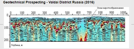
ABOUT CAPABILITIES FOR GEOTECHNIC FIELD OF SYSTEM:
Also,I share information about established how a performance of Acoustic Resonance Profiling technic for Geotechnical Prospecting field;

Source:mmeconsultant
Where,clearly understanding very selective karstic zone into apprx. 200 m level!!!!!!Thus,you will evaluate that about applying to similar procedure for hazardous structure regions caused of void type structures apart from Earthquake with a effective "ground control" procedure of hazardous structure/s after events as Earthquake.You are right.System also producing solutions as very powerful based on multi-functional under geotechnic concept
And,one example from Turkey region handled of RAP method which aims to understanding of liquefaction potential on multidisciplinary approach of a province into Canakkale settlement region(where,you will evaluate about perfect corelation conditioın of RAP technique with other techniques);
http://papers.16ecee.org/files/oztoprak%20et%20al.pdf
Where,I especially interest to performance of Acoustic Resonance Technique based on conclusions established on capable resistivity system.This point that underlining as a focal point to attention for especially geoenvironments!!!!!Also,clearly evaluating dominant advantages of Acoustic Resonance Technique with a column information as apprx.250 m.
You will remember that I expressed about requirement of some integrated approaches for water prospects.In this mean,I share a presentation link(Expedition:Androy) handled as detailed of Acoustic Resonance Profiling Technique with radiometrics(gamma survey);
https://www.google.com/search?q=igor+zuykov&safe=active&sxsrf=ALeKk01aswaEX29TSpvaDUd3LaA6xWdimA:1608309279797&source=lnms&tbm=isch&sa=X&ved=2ahUKEwjbjr76-tftAhWw_CoKHefxDq4Q_AUoAnoECBIQBA&biw=1366&bih=657#imgrc=YcXORsK-rxnDJM
By the way,part among 22-28 as page of publish presented is establishing valuable informations to geoenvironments on geotechnic concept with precious information about how handled with other Geophysics methods of Acoustic Technic;
Link about performance with other Geophysics applications of Acoustic Resonance Profiling technic:
Videos based on 3D visualisation and sections about Acoustic Resonance Profiling;
A example based on other integrated approaches about groundwater prospection.Where,subject a investigation about natural potential field caused of weak electric currents produced at upper zone of earth via electrode system as first application.Thus,handling a determination with experimental information background.Other steps;
Other example about handling to Acoustic Resonance Profiling with natural potential field technic.Where,shortly,you must attend to considered on orthogonal a route of acoustic profiling technic by considering to two profile determined with experimental information background on first technic.And,success of drilling as conclusion;
a introduction video as detailed about RAP-4 Acoustic Resonance System:
https://youtu.be/AF91niZ5SN8
I know some questions about undertook how a role of biogeophysical work for water surveys.This video thus including clear informations as answer to this questions;
A presentation about tectonic defects defined by Biogeophysical method and RAP profiles;
XxxxxxxxxxxxxxxxxxxxxxxxxxxxxxxxxxxX
Geophysicists on Acoustic Resonance Technic express that non-intrusive layer structures as vertical for Geotechnic Experts and intrusive layer structures for Hydrogeologists&Miners are ambitions of their.I harshly defend to solutions on 3D modelling concept against to this type conditions(This matter as evaluated is a important point on chapters as Engineering Geology,Geoecology and Discovery);

In the other hand,subject accessing on a MODIFICATION to apprx. 2000 m horizon!!! expressed for system.So,you must know that standart system packages are not supplying to this depth horizons!!!system weight on this modification is concluding with a increment as ~ 2x.But,very serious disadvantages of this condition are not subject.
I summary this condition via a presentation example on some questions about capabilities for tectonic structure evaluations of system;

Page information included some examples of ARP technique for mining field;
https://zolotodb.ru/article/12436
Nice a document summaried role for wide-range matters by needs of ARP technique;
http://minex.org/data/documents/MinEx-Geophysics-RAP-SBP-Jan2011.pdf
So,again emphasizing role as a reference system based on requirements as a whole of geoservice type firms👍
Valuable other presentation referenced section among info publishes of Minex;
http://minex.org/data/documents/MinEx-Geophysics-RAP-HARD-ROCK-Jan2011.pdf
Citing great role for some matters of horizontal distribution maps handled on ARP technique about mechanic strength of rocks...For informing about structure of such a application;

XxxxxxxxxxxxxxxxxxxxxxxxxxxxxxxxX
By the way,a information presentation about lighting to structure regions based on Magnetic(proton precession)-VLF EM-VES:
https://www.academia.edu/39117736/Geophysical_investigation_into_the_integrity_of_a_reclaimed_open_dumpsite_for_civil_engineering_purpose?aut
o=download&email_work_card=download-paper
Link summaried a approach integrated on environmental concept with proton magnetometer system of VES technique;
http://www.langeoinstrument.com/case/132.html
I know serious questions about established how a role for water prospections of Proton Precession Magnetometers...In this mean,a clear explanation page based on physical principles which evaluating as extreme informative;
(Note.Also,link is presenting valuable other informations about magnetometer systems)
I share easy but very informative video link about established how responses based on groundwater flow of a magnetometer system.Alphalab Scientific Instruments recognize for Calibration Fields with Gaussmeters,Electrostatic Voltmeters,Air Ion Counters and Voltage Measurements. Where,A Earth Magnetometer(Model EM2) application video based on Gaussmeters of firm is signing to chapter as groundwater flow about location related of Czech Republic/Brno;
Thus,I harshly think that carried-out nice informations to you about considered on how principles based on Magnetometers of Groundwater Presence(I will wait for your appreciated replies).

You are right!!!by experiments established on principles of Earth Magnetometer is understanding some expressions known as literature on flow characteristics of Groundwaters(Where,I mean that especially citing to expressions as underground rivers!!!So,this concept is not a myth,mainpoint is related to related system experiments).
Other survey example about Earth Magnetometer system;
By the way,we can express via considering to development chapters of Magnetometer Systems on handling with Actual Technologic Developments that "different measurement technics" of Magnetometer Systems and thus,summarying emerged of evaluation&presentation shapes.In this conclusion,based on system handled for Magnetometers ;
¡)Measurement Structure
¡¡)Data Evaluation
¡¡¡)Presentation Shapes
are important.So,you must have to some pre-informations for this headlines.You are right!!!Where,"establishing to solution by AIM" is pinpoint.Othwerwise,you confront to events concluded with problematic conditions!!!
Detailed presentation of a 'multiple methodic application' for understanding to effect of Magnetic Survey(GEM system) with role of Electrometric Technics;
https://docplayer.ru/63354225-Elektrorazvedochnye-tehnologii-pri-poiskah-podzemnyh-vod-v-skalnyh-massivah.html
By the way,subject presentation on a integrated approach about Earth Magnetometer System of Alpha Lab;
https://www.youtube.com/watch?v=NsblYvwvicc&list=LLOFwOH3xvtZxb6YFYcU9iIQ
Note.There are some question marks about blue device used of suveyor.This system is PQWT water detector produced by China.A introductory video for Model S500;
https://www.youtube.com/watch?v=ID0qAJy62h8&list=LLOFwOH3xvtZxb6YFYcU9iIQ
PQWT devices have different models...And,technic presentations detailed about models are not subject...Establihed a presentation of Mr.Raj Geo about profile survey and profile chapters as information(probably,evaluated as TC model);
https://www.youtube.com/watch?v=tvxZba2r43Q
Other presentation about profile chapters;
https://www.youtube.com/watch?v=1r7Qdeqd19Y
A survey application handled on integrate approach of PQWT device with GER detector device;
https://www.youtube.com/watch?v=j9mIpokfO_k
Why suggesting to evaluations as Magnetic Surveys?
Quarry impact example sourced from a lake environment as related to how handled about groundwater flow of TEM;
http://azimut-geology.kz/geophysics_all/86-voda_karier.html
In the other hand,emphasizing to shaping of a idea of groundwater contour distribution on technics based on chapters as depth-target field for your constrained land before TEM.So,determinant factor of latest TEM concept is such a focal!Again you are right!!!And next,TEM conclusion thus must be yield at confirmative point to your model.
I give a "Aquifer Storage and Recovery(ASR)" project from Dubai Desert Enviroment as other example about handling on some experiments of TEM method(Where,I think on reference of a experimental condition caused of especially "seismic exploration applications" about region);
https://www.youtube.com/watch?v=yr_Kg7s5EEQ
For informations detailed about chapter as complementary;
https://aesg-me.com/portfolio-item/aquifer-storage-and-recovery/
Some information pages about ASR chapter;
https://www.usgs.gov/centers/ca-water/science/aquifer-storage-and-recovery?qt-science_center_objects=0#qt-science_center_objects
https://www.epa.gov/uic/aquifer-recharge-and-aquifer-storage-and-recovery
https://en.wikipedia.org/wiki/Aquifer_storage_and_recovery
Expresses on literature established a perfect solution for Paleovalley type structures of TEM technique!!!Thus,I summary this condition with a sectional example;

Source:Elgeo Ltd.(Research and Production Company)
Where,documenting perfect solution of TEM for conditions as presence of a relatively resistive zone into conductive zone...You are right!!!As evaluated,also,understanding selective performance of system for isssues as some geohazard type conditions.
By the way,I share a guideline webinar about how handling TEM for rapid resistivity sounding;
https://www.youtube.com/watch?v=sgt9YzzT0k0&list=LL&index=1
A hydrogeologic application on geochemical tracers of TEM technique at coastal aquifer location!!!;
https://www.researchgate.net/publication/265694032_Use_of_a_time-domain_electromagnetic_method_with_geochemical_tracers_to_explore_the_salinity_anomalies_in_a_small_coastal_aquifer_in_north-east_Tunisia
Again I return to exploration headline on Magnetic Principles...Expressing Geominax Geomagnetic Tracker as selecive a system among World's innovative equipments to understanding Earth's Magnetic Field Difference on Geomagnetic principles!!!This system shortly calculates differences for each axis presented;
https://www.youtube.com/watch?v=AZ1owlP7ANk&list=LL&index=22
Note.This video is establishing a nice info about how a mathematical background during data evaluation of system.A explanation page as more detailed thus will be cause to more clear determinations;
http://siddhani.com/GMT-120.html
https://www.youtube.com/watch?v=YsfU7C7BaPo&list=LL&index=23
https://www.youtube.com/watch?v=ovUf_Fdz32E&list=LL&index=21
https://www.youtube.com/watch?v=VIcrggV27FU&list=LL&index=20
https://www.youtube.com/watch?v=3M_egyMTGIU&list=LL&index=19
https://www.youtube.com/watch?v=ywZsSe5FdZg&list=LL&index=17
https://www.youtube.com/watch?v=o5dByOoz4w4&list=LL&index=7
I especially interest location determination technique of Raj Geo among link sharings👍So,observing powerful a integration procedure about a field constraint technique based on groundwater flow of surveyor on surface signing methodology👍👍👍
Next,I especially interest to fourth introduction video of Raj Geo!!!This application,summarying as a yield of magnetic technqiues as a whole(So,I emphasize that distinction of two system(GMT-1200+ and GMT-1200) of Geominax for this introduction is overlooking!!!!!).As conclusion,this condition is summarying performance based on exploration of magnetic principles.Where,shortly,GMT-1200+ has to mission under a stable station position .And next, expressing progress of GMT-1200 on conclusion established of this condition👍
By the way,selective device among dowsing systems by magnetic principles of Geominax;
https://www.youtube.com/watch?v=UlOM2tvJDx8
Introductory presentations of Mr.Srinivas and Raj Geo about system:
https://www.youtube.com/watch?v=ZfBj9JX2rlA&list=LL&index=1
Where,I especially say that this system is expressing a structure summaried under two component as main!!!

You are right!!!understanding a whole system on depth detection device...Thus,fixing a depth detection system condition of GMT-1200+ as a comparison👍But,where,a component similar GMT-1200 is not subject!!!
I say role big of this video for some matters about mystery of two component system👌;
https://www.youtube.com/watch?v=Ca_XitH_quc&feature=youtu.be
Survey examples as more clear of GMT-1200 device;
https://www.youtube.com/watch?v=VIcrggV27FU
https://www.youtube.com/watch?v=sudUeGfL1J8
And,survey example on GER detection device of same day(possibly,same survey location)
https://www.youtube.com/watch?v=UtAy3L2Dzv4
Other survey examples handled as integrate of GMT-1200 device with GER detection device;
https://www.youtube.com/watch?v=96MPosB6_JY
https://www.youtube.com/watch?v=j7cycN5fI1s
Survey example performed of GMT-1200 and GMT-1200+ devices with GER detection device;
https://www.youtube.com/watch?v=mOaQ8qcW9hg
After video,I share some informations about technic principle as geophysical of GMT-1200 device.Firstly,video presentation;
https://www.youtube.com/watch?v=H4QBZpv3LAI
You know that subject modelling approaches based on BH-1,BH-2 and BH-3 components for Physics and various chapter related.Thus,video is summarying sensing via survey concept of Geomagnetic Zone on this components.So,you can think as pratic that as observing focus contour on a magnetic map produced as computer-aided on BH-1,BH-2 and BH-3 components!!!!(So,Surveyor is catching during survey this contour stru. 👍)
Next, G-track Pro System of Matrix Detectors among other dowsing systems is summarying selective a structure.I share a full intro. presentation by Mr.Srinivas as supplementary this thesis;
https://youtu.be/_rjmPP7K1Rg
Device is expressing as VLF based Longrange system.Other presentation;
https://www.youtube.com/watch?v=h0qUZQtfZ0w
Evaluation:I clearly express established perfect a solution against to reporting matters with realtime procedure based on transmitter of VLF based Longrange system.Summarying established big a impulse to especially water exploration applications of this system based on VLF👍Next, good solution ground survey matters for some aims thus expressing.
Thus,as a geophysicist,I clearly express VLF based longrange system as my another harsh suggestion to needs of GeoService firms👍. Not only under a flowchart structure summaried on upper part considering reporting matters of this system but also nice solutions by add capabilities expressed of device thus summarying as 'a big impact' for job flowchart models of GeoService Firms👍👍👍
Next,I remember that subject some info requests about how established of easiest profiling approach with autonomous long range dowsing systems .In this mean,a presentation about established how a profiling via reference of GER Long Range Detection System of Mr.Raj Geo(evaluating as easiest profiling approach for conclusion);
https://www.youtube.com/watch?v=o5dByOoz4w4&list=LL
Hydrogeology field on Deep GPR technologies:
Where,we can summary that Loza Systems are presenting focal a position;
Expressing RotegGPR as other Deep GPR System for "Karstic Structures" field on some reference informations as Slovenia-Czech Republic.
So,I suggest as Geophysicist that not only water explorations for this type Geoenvironments but also for chapters as geohazard potential related to settlement/s due to this type geoenvironments.
Postojna – depth test
Štramberk-2017(Speleology Report)
Pytlikova cave-2015(Speleology Report)
Holstein cave-2015(Speleology Report)
Blansko-2015(Speleology Report)
Ostrov u Macochy-2015(Speleology Report)
A compilation about some results of Ground Penetrating Radar measurements with the large penetration depth based on Roteg GPR;
Report about Ostrovska Plateau of Chairman Filip Dolezal from Czech Speleological Society;
 During expressions about Roteg GPR capabilities,I remembered about issues as cancellation conditions as direct of some projects for Karstic Provinces due to disabilities based on route.We can summary to problems realised for establishing as required to road meshes as maybe most interesting structures into this headline.Because you know that different charge-dischage conditions are causing to very serious conclusions with dynamic specifications of karstic conditions!!!In this mean,I summary to established a perfect solution for route projects on different aims of Roteg GPR presentations.

We express as a conclusion of experiments caused of handling for karstic provinces of Deep GPR systems that about undertook a active role to development of "speleologic communities/organisations/societies" as direct of many appliers or about caused to role based on establishing of a supplementary data to organised speleologic communities/organisation/societies for this field of Deep GPR applications handled at this type provinces(You remember that report of Chairman Filip Dolezal from Czech Speleological Society presented as only one example.And next,you know that about hardness of some procedures for mapping applications until neartime frames of speleologic communities/organisations/societies!!!My second expressions considered as a solution for this condition...You are right!So,I shortly mean that speleologists have to big pre-supplies based on chapters as mapping and discoveries on actual technologic capabilities of Deep GPR Systems👌).
Note.Subject big experiments for this chapters on near countries to Czech Republic based on Deep GPR.In the other hand,knowing a selective literature background on speleologic chapters of France.
By the way,I especially must express that often citing to conditions about understanding as required to "cave system anatomy" as base point of some problems based on "speleologic tourism".You are right!!!So,I emphasize to role of Deep GPR Systems for lighting to this type conditions.
I will wait for your appreciated replies...news about physical description of a corridor( Divaška Jama corridors ) as maybe "most meaningful example" to this expressions;
In the other hand,I must mention to solutions as dominant open source coded based on geochemical of matter about especially fixing to "water flow chapter".Where,subject software solutions based on modules as numpy-scipy-matplotlib-pyqt5 of Python as open source coded with geochemical modelling packages as PHREEQC,PHAST,interactive Hydra/Medusa for geochemical modelling.Also, numerical groundwater model packages such as MODFLOW and MT3D are requiring as experience.Thus,
- Water Chemistry Concept(alkalinity,redox,competitive surface complexation)
- Some knowledge of mineralogy
- An understanding of basic flow and transport concepts for saturated and partially-saturated porous media
Establishing "healthy determination" about groundwater flow based on headlines.You are right!!! Not only solution to conditions as flow on this concept but also understanding solution about a matter as chemical structure of water.For a introductory video:
Rod Dowsing is important exploration technic based on principles.But,producing conclusion with a combinations of some different land experiments with some individual characteristics of appliers!!!So,serious restrictive condition based on only applier...In this mean,today,subject equipments carried-out to conclusions as equivalent to role of rod dowsing equipped with electronic systems.For example;
https://www.youtube.com/watch?v=FKh1OgBNUjI&list=LLOFwOH3xvtZxb6YFYcU9iIQ&index=16&t=0s
https://www.youtube.com/watch?v=-RxDxn_VuXo&list=LLOFwOH3xvtZxb6YFYcU9iIQ&index=15&t=0s
https://www.youtube.com/watch?v=mgx1LC2hD-0&list=LLOFwOH3xvtZxb6YFYcU9iIQ&index=14&t=0s
https://www.youtube.com/watch?v=JuK85daF5II&list=LLOFwOH3xvtZxb6YFYcU9iIQ&index=13&t=0s
As evaluated,if you have to disability conditions on classic rod dowsing,understanding established perfect solutions against to this type conditions of electronic systems(I emphasize to mission as important a component of this type systems on integrated geophysics application concepts).As only some examples,handling with Acoustic Resonance Technique of pre-determined field/s on this system,handling with Transient Electromagnetic Technique of pre-determined field/s on this system(as referred under upper part).
Also,interesting Geo-Master system progressed on chapters as long range,geo magnetic,geo frequency,very low frequency and transmission with a system expressed as 3D Locator(3DL) on electronic rod dowsing concept;
https://www.youtube.com/watch?v=Jiyx69i73WE&list=LLOFwOH3xvtZxb6YFYcU9iIQ&index=11&t=0s
https://www.youtube.com/watch?v=HDUGp2Dsp7E&list=LLOFwOH3xvtZxb6YFYcU9iIQ&index=12&t=0s
Technic explanations detailed of Vysaly Detector Systems;
https://youtu.be/fewQsHi6FVo
https://youtu.be/N5xZ7JUJWgU
https://youtu.be/HDUGp2Dsp7E
https://youtu.be/eEx3S8Kiu1g
Note.Last video is summarying informations about unbiased reporting matters
In the other hand,a nice presentation about ubiased reporting matters by Mr.Srinivas;
https://www.youtube.com/watch?v=oOUVV6OL9KY&list=LL&index=2
3D locator system is not a mystery...Presentation thus including clear informations;

Modern Omega Device of Ajax Technology among long-range detection systems is other selective system!!!introduction video detailed of this system;
https://www.youtube.com/watch?v=pAt-_dBQLjM
A introductory video based on application of system;
https://www.youtube.com/watch?v=Bxn3i9YjefI
Longrange detection systems&Geohazard issues:
Also,we can express summaried very useful a concept against to some geohazard matters of Longrange systems(I presented one example about causes of subsidence type mechanisms for Karstic envs.Where,I cite role of hydraulic characteristics of upper zones among effect mechanisms
settlements of Karstic envs.);

Suggesting long range systems among easiest geophysics approaches
for detecting this type locations...Geohazards on Karstic envs
are expressing really big matters.In this point,I framed a approach
(Thus,I will wait your experimental replies).Thanks...
Interesting systems summaried as Willowstick Technologies among most effective geophysics techniques expressed for "groundwater system modelling and mapping" based on flow paths.Sign to role for understanding to impacts sourced due to man-made water structures or water effects of this systems on principles.For informations on case studies;
https://www.environmental-expert.com/products/willowstick-groundwater-system-modeling-and-mapping-235781
A pdf document as more detailed;
http://www.geo9.com.au/images/willowstick_leading_edge.pdf
# By the way,expressed as ADMT at China and a frequency measurement system progressed based on Natural Earth EM Field as source;#
https://www.youtube.com/watch?v=GmPzTZ_zWn4
https://www.youtube.com/watch?v=4OwqfRPzxfc
Expressing characteristics as establishing to fast and extreme efficient conlusions with some capabilities integrated to Mobile Phone of system(Note.Subject specifications as wireless sensor system with ground probes of system).And, you will evaluate on video series as a whole of Алексей Бяков that ADMT system is very powerful tool( clearly expressing another example to this condition with second video about how handled of Acoustic Resonance Profiling technic).
There are some question marks about unbiased reports.Thus,I will establish a expansion about this chapter...I mean about unbiased report chapter that handling on 'independent routines' survey conclusions of GeoService Firms is a requirement.So,as evaluated,role of any outer effect to conclusions is causing to big problems!!!(Unfortunately, subject incredible histories on this headline of firms,public field and even academic environments)
A selective publish by Reinhard Kirsch:
There are some interesting publishes on literature scanning based on Hydrogeologic chapters...Such a publish example by Reinhard Kirsch is especially suggesting for acquiring important informations about Geophysics technics;
https://www.researchgate.net/publication/252397169_Groundwater_Geophysics_A_Tool_for_Hydrogeology
I open file based on Resistivity:
You will remember that I expressed to risky nature on some matters of water exploration chapters via one classic resistivity device as single.ABEM Terrameter among important resistivity systems handled for water exploration mission based on "applicability to different land structures" as geologic is expressing a independent structure by this situation!!!Not only advantages established with "handling process steps as a whole via integrated panel system" chapter but also including advantages as considering of IP applications!!!I established some introductory videos(I especially emphasize to wide range of chapters as application fieds at geologic environments);
https://www.youtube.com/watch?v=NlDn07OA2W0&list=LLOFwOH3xvtZxb6YFYcU9iIQ&index=12
https://www.youtube.com/watch?v=UR-qy7hNWHQ
https://www.youtube.com/watch?v=IW58ZZJknHo&list=LLOFwOH3xvtZxb6YFYcU9iIQ&index=2
https://www.youtube.com/watch?v=oB22OUj0ZZ4&list=LLOFwOH3xvtZxb6YFYcU9iIQ&index=1
https://www.youtube.com/watch?v=R-JkoPbnka4
https://www.youtube.com/watch?v=PhShM-cpIAc
https://www.youtube.com/watch?v=jjtY-Xu_-Bw
I express capabilities on "water mapping" headline of system;
Also,I underline to usefulness on other application fields of this system;

>Mineral Mapping
>Pre-Construction Engineering Survey
>Hazard Mapping
>Pollution Mapping
>General Geological Sequencing
>Sediment Mapping(Marine)
>Cultural Heritage
Important Note.I especially inform that about established big advantages to users on electronic circuit characteristics against to chapters as reparing;
https://www.youtube.com/watch?v=Oqby-gu6JF4
I can express syscal pro switch-72 model as other selective device among important resistivity systems;
https://www.aimil.com/products/syscal-pro-switch-72
Subject nice a presentation about established how a solution for harsh environments as geologic of system;
https://m.youtube.com/watch?v=xqzm5JjHCiE
Note. I especially emphasize to role of pre-informations established of some visual observations for shaping of survey on this application.So,if you observe similar indicators on your life provinces,expressing solutions on similar procedure👍In the other hand,role of system for detecting perfect flow location is understanding as maybe most critic point👍
#Role of applicable procedure#
I especially emphasize to selection chapter of appropriate anomaly among two anomalies on IP section.In this conclusion,considering as drilling location of surficial anomaly thus increasing possibility of facing to serious problems for flow stability chapters with such a geologic structure!!!In this mean,progressing of a procedure based on only drilling will cause to big disadvantages on some sub-chapters👍You are right!!!Shortly I mean that only "There is water here" expression is not required a information for drillers👍
I open water exploration file on integration of Electric(Syscal Pro Switch-72)&EM(MTU5 Phoenix) Methods:
Tectonic structure developments for some limestone stratigraphies reflect deeper a condition under topographic conditions of land.Handling by a integrated approach AMT system on supply of resistivity system against to such conditions thus producing positive conclusions!!!
https://www.youtube.com/watch?v=Rm1ga0ZDahU
Also,topography profile about region which reflecting topographic a valley conditon;
You know that related AMT System is expressing solutions under low resolution based on depth.Thus,you will evaluate as a whole handling of especially AMT 3D Volume Analysis with conclusions established of resistivity system!!!(Also,I emphasize to calibration chapter with two ERT line at video presentation)
By the way,I will share some informations about using based on which fields ERT technique;
Geophysical and hydrogeochemical analysis for evaluate groundwater mineralisation and extension:
https://www.researchgate.net/publication/271853951_Evaluation_of_groundwater_mineralization_processes_and_seawater_intrusion_extension_in_the_coastal_aquifer_of_Oualidia_Morocco_hydrochemical_and_geophysical_approach
Performance establsihed at coastal aquifer regions based on brackish-salty water discrimination of ERT Technique:
https://www.academia.edu/11159859/Assessment_of_shallow_aquifer_salinity_in_the_Aqaba_Coastal_plain_using_ERT_method_a_case_study_of_Maqnah_region_northwestern_Saudi_Arabia
ERT about handling based on layer's extension geometry of intrusive development:
https://www.researchgate.net/publication/339442486_2-D_Electrical_Resistivity_Tomography_ERT_For_Delineating_Saltwater_Intrusion_in_the_Coastal_Region_of_AKWA_IBOM_State_Nigeria
Evaluating hard rock aquifers:
https://www.researchgate.net/publication/325489365_Groundwater_of_Hard_Rock_Aquifers_of_India
Geotechnic solution based on water saturation(historic stru example):
We can say to modelling of volume saturated among popular user fields of ERT technique.Ground stru can extend a volume saturated as related to water content due to various cause.This condition is appearing as important problems on some chapters.For example,a presentation is documenting relationship to leakage caused of a collector system as geotechnic of matter as a conclusion of handling with ERT technique of such a problem realised at historic location;
https://youtu.be/ZuI5XnxLluI
Multicomponent Water Detection System:
I especially emphasize to River-G expressed among water detector terminologies as a system based on multicomponents;
https://gerdetect-qa.com/underground-water-detectors/river-g.php
https://www.youtube.com/watch?v=ddr9mt1yeBg&list=LL&index=28
You know that River-G characterized by three systems for the detection of groundwater, artesian wells and bore wells in the ground.Link for land application of system;
https://www.youtube.com/watch?v=523EnnlYIxk
https://www.youtube.com/watch?v=523EnnlYIxk
As evaluated,subject a specification as in-situ unbiased reporting based on water specifications of system !!! So,not only solution for pre-applications as drilling but also a system structure designed for chapters as inspection/control on different aims👍(You know that chapters as condition of groundwater due to different causes(geologic or manmade) consider on some matters).In this point,I harshly suggest structure of system👍
GAMA POTENTIAL FILE:
You will remember that about solution established for weak geologic basement on surface area potential of SP!!!In this point,you again remember survey application about GAMA POTENTIAL among links...We express via considering as a whole of this applications that about caused to how a solution based on "weathering zones" for "hard geologic basement" environments of GAMA POTENTIAL surveys👍 In this mean,as evaluated,handling as target provinces on water potential to fields observed of low gama values with surficial position of outcrop structures for fields caused of high gama values at hard geologic basement regions;

Requiring detailed Geophysics applications for target zones determined after this stage.So,role of Acoustic Resonance Profiling on a VES Survey planned for target zones thus especially emphasizing.
If you have a 'assertive lithology model' on some powerful geologic data or geophysics techniques,subject usefulness of only VES on such a lithology information👍You are right!You will evaluate that expressing some informations on literature despite to qualified applications on chapters as number&quality at some harsh environments as geologic!!!Summarying caused from some disability conditions for carrying out 'assertive a lithologic model ' of this conditio
Also,I especially present a integrated approach on concept(rapidness&cost effectness).Thus,you will inform about quick mapping & subsurface imaging tool for scanning structures;
https://www.hindawi.com/journals/ijge/2014/969462/
other integrated example with VLF-EM of Gama Radiometry;
https://www.researchgate.net/publication/283962387_Application_of_gamma_ray_spectrometric_measurements_and_VLF-EM_data_for_tracing_vein_type_uranium_mineralization_El-Sela_area_South_Eastern_Desert_Egypt/link/56e71d2b08ae4cbe4d42b6b4/download
VLF-EM_VES BASED ON WATER EXPLORATION :
You will remember that I shared about how handled on integrated approach of a VLF application into upper parts.In this point,I summary a publish signed role of two application as water exploration for relatively 'harsh a environment' at overburden- bedrock system;

By the way,how determining flow matters on VES principles is among frequently questions expressed by geoenvironments...I share a link on this aim(Also,Subject informations about how handled of some issues);
https://www.academia.edu/keypass/NkJiRzRXQlFCWitKS2JkT3gvRW55aFF2Vkd3SnFwYWRWNkxXcDI5aVNmYz0tLUJVbkM3c2VGd1hpNjF1eDZZMHlCL2c9PQ==--67e03a2b2cd29039f39828af9bf64972e64e2837/t/fsDHF-Pd0Zf8n-bmR8Tg/resource/work/29552425/Investigation_of_groundwater_flow_potential_in_Makurdi_North_Central_Nigeria_using_surficial_electrical_resistivity_method?email_work_card=title
Link included some informations as complementary this article;
https://www.academia.edu/31617290/INYANG_PUB_2017_pdf?auto=download&email_work_card=download-paper
VES technique is really a Joker!!!Thus,a integrated Geophysics approach( with Gamma) based on "How evaluated of Magnetic Data as dominant at Magnetic Crystalline Basement regions" of VES technique;
https://www.academia.edu/38206306/Bem_Shadrach_paper_pdf?auto=download&email_work_card=download-paper
For article about how concluded via satellite images as dominant of VES technique;
https://www.academia.edu/41392064/Assessment_of_Aquifer_Hydraulic_Properties_Groundwater_Potential_and_Vulnerability_Integrating_Geoelectric_Methods_with_SRTM_DEM_And_LANDSAT_7_ETM_Lineament_Analysis_in_Parts_of_Cross_River_State_Nigeria?auto=download&email_work_card=download-paper
Article information about how progressed on EM system(Geonics EM-34) of VES;
https://www.academia.edu/33582051/Aquifers_Characterization_and_Classification_Using_Electromagnetic_and_Galvanic_Resistivity_Methods_in_Basement_Complex_Katsina_Ala_Central_Nigeria?auto=download&email_work_card=download-paper
Some geoenvironments wonder how handled about chapters summaried as water quality on Dar-Zarrouk parameters of VES.Where,I especially express a background known as literature of OYO McOHM resistivity systems....A information paper:
https://www.researchgate.net/publication/318710676_Natural_Vulnerability_Estimate_of_Groundwater_Resources_in_the_Coastal_Area_of_Ibaka_Community_Using_Dar_Zarrouk_Geoelectrical_Parameters
Other informative article about Groundwater Aquifer Vulnerability Assessment:
https://www.researchgate.net/publication/338962536_Groundwater_Aquifer_Vulnerability_Assessment_using_a_Dar-Zarrouk_Parameter_in_a_Proposed_Aboru_Residential_Estate_Lagos_State_Nigeria/link/5e34efa4299bf1cdb9027c21/download
Descriptive article about how handled with Hydrochemical data of VES
http://www.dergipark.org.tr/tr/download/article-file/1152386
For article information about Winresist based on smoothness constrained optimisation technique used to refine the geoelectric features induced from manual interpretation of each VES data;
https://www.academia.edu/29988620/Geophysical_Characterization_of_Aquifer_Parameters_within_Basement_Complex_Rocks_Using_Electrical_Sounding_Data_from_the_Polytechnic_Ibadan_Southwestern_Nigeria?auto=download&email_work_card=download-paper
VES technique is how handling for either feasibility or inspection based on contamination fields?
Good information page for answer of this question;
https://link.springer.com/article/10.1007/s13201-016-0393-4
Understanding 'essential a role' for geophysicists as a whole of VES technique on informations...You are right👍Geophysicists reached to good information background based on this chapter are catching important a power on private sector👍
https://www.academia.edu/8380965/AASR_2012_4_5_2077_2093?auto=download&email_work_card=download-paper
https://www.academia.edu/32496776/Geophysical_investigations_for_groundwater_in_a_hard_rock_terrain_Salem_district_Tamil_Nadu_India?auto=download&email_work_card=download-paper
https://www.academia.edu/40927789/A_Probe_into_the_Corrosivity_Level_and_Aquifer_Protective_Capacity_of_the_Main_Campus_of_the_University_of_Abuja_Nigeria_Using_Resistivity_Method?auto=download&email_work_card=download-paper
https://www.academia.edu/29356041/Geophysical_Investigations_of_Lithology_and_Ground_Water_Potentials_of_Recharge_Zones?auto=download&email_work_card=download-paper
https://www.academia.edu/11403430/Mapping_Precambrian_Aquifer_Architecture_in_Fractured_Hydrogeological_Setting_with_Vertical_Electrical_Sounding?auto=download&email_work_card=download-paper
https://www.academia.edu/38427761/Delineation_of_potential_ground_water_zones_pdf?auto=download&email_work_card=download-paper
https://www.academia.edu/13121665/Electrical_resistivity_survey_for_groundwater_investigations_and_shallow_subsurface_evaluation_of_the_basaltic_greenstone_formation_of_the_urban_Bulawayo_aquifer?auto=download&email_work_card=download-paper
https://www.academia.edu/13753690/MR?auto=download&email_work_card=download-paper
https://www.academia.edu/42671222/Geoelectric_Assessment_of_Groundwater_Potential_in_Supare_Akoko_Southwestern_Nigeria?auto=download&email_work_card=download-paper
https://www.academia.edu/12458967/Discovery_of_Perched_Aquifer_When_Assessing_Aquifer_Potential_along_the_floodplain_of_the_Upper_Benue_River_NE_Nigeria?auto=download&email_work_card=download-paper
https://www.academia.edu/41692168/Integrated_Geophysical_Investigations_for_Groundwater_Development_in_a_Challenging_Hard_Rock_Terrain_Adeyemo_et_al_201920200121_16910_11?auto=download&email_work_card=download-paper
https://www.academia.edu/36814609/Evaluation_of_Groundwater_Prospect_in_a_Clay_Dominated_Environment_of_Central_Kwara_State_Southwestern_Nigeria?auto=download&email_work_card=download-paper
https://www.academia.edu/22537865/1D_Geoelectrical_Resistivity_Survey_for_Groundwater_Studies_in_Coastal_Area_A_Case_Study_from_Pearl_City_Tamil_Nadu?email_work_card=title
https://www.academia.edu/380627/Hydrogeological_framework_and_estimation_of_aquifer_hydraulic_parameters_using_geoelectrical_data_A_case_study_from_West_Iran?auto=download&email_work_card=download-paper
https://www.academia.edu/33439476/Using_Geo_Electrical_Method_of_Estimation_In_Groundwater_For_Irrigation_Potentials_Of_Kiyi_Community_Kuje_Area_Council_Abuja_Nigeria?auto=download&email_work_card=download-paper
https://www.academia.edu/32059367/Tertiary_Recent_sediments_Terti_ary_volcanics_Cretaceous_Benin_Flank_Cal_abar_Fl_ank_Jurassic_Younger_granites_Precambri_an_Basement_Major_reference_town_200_km?auto=download&email_work_card=download-paper
https://www.academia.edu/4488452/Assessment_of_hydrogeological_conditions_in_basement_aquifers_of_the_Precambrian_Oban_massif_southeastern_Nigeria?auto=download&email_work_card=download-paper
https://www.academia.edu/38195065/IGU_NRK_pdf?auto=download&email_work_card=download-paper
https://www.academia.edu/8168899/Groundwater_system_evaluation_and_protective_capacity_of_overburden_material_at_Ile_olujI_Southwestern_Nigeria?auto=download&email_work_card=download-paper
https://www.academia.edu/37958515/GEO_ELECTRICAL_DATA_ANALYSIS_TO_DEMARCATE_GROUNDWATER_POCKET_ZONES_IN_KALTUNGO_AND_ENVIRONES_NORTHEASTERN_NIGERIA?auto=download&email_work_card=download-paper
https://www.academia.edu/28865673/GEOELECTRICAL_HYDROGEOLOGICAL_PARAMETERS_OF_GROUNDWATER_AQUIFERS?auto=download&email_work_card=download-paper
https://www.academia.edu/14902155/Aquifers_productivity_in_the_Panafrican_context?auto=download&email_work_card=download-paper
https://www.academia.edu/24552524/Deciphering_transmissivity_and_hydraulic_conductivity_of_the_aquifer_by_vertical_electrical_sounding_VES_experiments_in_Northwest_Bangladesh?auto=download&email_work_card=download-paper
https://www.academia.edu/28865598/Geoelectrical_Hydraulic_study_along_Guwair_proposed_dam_Axis_PhD_Seminar_homework_?auto=download&email_work_card=download-paper
https://www.academia.edu/5889028/Resistivity_Asam_EMA_2012?auto=download&email_work_card=download-paper
https://www.academia.edu/40616511/SUSTAINABILITY_OF_A_BOREHOLE_SOURCE_FOR_WATER_SUPPLY_A_CASE_STUDY_AT_K_T_HALL_OF_UMaT?auto=download&email_work_card=download-paper
https://www.academia.edu/501686/Three_dimensional_electrical_resistivity_imaging_of_a_gold_heap?auto=download&email_work_card=download-paper
https://www.academia.edu/8380957/The_Hydro_Geophysical_Investigation_of_Oyo_State_Industrial_Estate_Ogbomosho_Southwestern_Nigeria_Using_Vertical_Electrical_Soundings?auto=download&email_work_card=download-paper
https://www.academia.edu/19956223/A_Spatio_Aquiferous_Assessment_of_Groundwater_Potentials_in_Bagwai_and_Shanono_LGAs_Kano_State_Nigeria?auto=download&email_work_card=download-paper
https://www.academia.edu/40927885/Determination_of_Groundwater_Potential_in_the_Permanent_site_of_University_of_Abuja_FCT_Nigeria?auto=download&email_work_card=download-paper
https://www.academia.edu/38867862/APPLICATION_OF_2D_ELECTRICAL_RESISTIVITY_TOMOGRAPHY_TO_ASSESS_THE_INFLUENCE_OF_GEOLOGY_AND_GEOLOGICAL_STRUCTURES_ON_GROUNDWATER_OCCURRENCE_AND_POTENTIAL_IN_KONZA_AREA_KENYA?auto=download&email_work_card=download-paper
https://www.academia.edu/14846622/Contribution_of_Geophysical_properties_in_estimating_the_Hydrogeological_parameters_of_an_aquifer?email_work_card=view-paper
https://www.academia.edu/19383890/Estimates_of_Aquifer_Hydraulic_Characteristics_and_Vulnerability_from_Surface_Resistivity_Data_Case_Study_of_Ugep_and_Environs_Southeastern_Nigeria?auto=download&email_work_card=download-paper
https://www.academia.edu/31992220/Amos_Uhegbu_et_al_pdf?auto=download&email_work_card=download-paper
https://www.academia.edu/38525370/An_integrated_approach_for_aquifer_characterization_and_groundwater_productivity_evaluation_in_the_Lake_Haramaya_watershed_Ethiopia?auto=download&email_work_card=download-paper
https://www.academia.edu/42727820/Electrical_Resistivity_Survey_for_Groundwater_Investigation_in_Kano_Metropolis_Nigeria20200413_29919_1nyx5qf?auto=download&email_work_card=download-paper
https://www.academia.edu/36464504/Application_of_multi_criteria_decision_analysis_in_prediction_of_groundwater_resources_potential_A_case_of_Oke_Ana_Ilesa_Area_Southwestern_Nigeria?auto=download&email_work_card=download-paper
https://www.academia.edu/40817476/Comparing_the_Groundwater_Potentials_of_the_Geology_of_Sierra_Leone_Freetown_Igneous_Complex_and_the_Granite_Greenstone_Terrain_in_Sierra_Leone_Using_Geophysical_Survey_Data_and_Borehole_Logs?auto=download&email_work_card=download-paper
https://www.academia.edu/6805065/Geoelectric_Investigation_of_Aquifer_Vulnerability_within_Afe?auto=download&email_work_card=download-paper
https://www.academia.edu/21218386/Groundwater_Prospecting_and_Exploration_in_a_Low_Potential_Hard_Rock_Aquifer_Case_Study_from_Ogbomoso_North_South_western_Nigeria?email_work_card=view-paper
https://www.academia.edu/8169185/Geophysical_evaluation_of_rock_type_impact_on_aquifer_characterization_in_the_basement_complex_areas_of_Ondo_State_SW_Nigeria_Geo_electric_assessment_and_GIS_approach?email_work_card=view-paper
https://www.academia.edu/40689611/A_TECHNICAL_REPORT_ON_APPLICATION_OF_INTEGRATED_GEOPHYSICAL_TECHNIQUES_IN_THE_INVESTIGATION_OF_GROUNDWATER_POTENTIAL?auto=download&email_work_card=download-paper
https://www.academia.edu/12209678/THE_INTERNATIONAL_JOURNAL_OF_SCIENCE_and_TECHNOLEDGE_Formation_Characterization_and_Groundwater_Prospect_of_Federal_College_of_Education_Technical_Gusau_Zamfara_State_Using_Resistivity_Method?auto=download&email_work_card=download-paper
https://www.academia.edu/36138643/Deliniation_of_Viable_Drilling_Piont_at_Selected_Location_in_Ibadan_Using_VES_I_T_Report_PDF_?auto=download&email_work_card=download-paper
https://www.academia.edu/39117761/Geoimaging_of_subsurface_fabric_in_Awgbagba_Southwestern_Nigeria_using_geomagnetic_and_geoelectrical_techniques?auto=download&email_work_card=download-paper
https://www.academia.edu/39507386/DETERMINATION_OF_GROUNDWATER_QUALITY_AND_AQUIFER_PROTECTIVE_CAPACITY_USING_ELECTRICAL_RESISTIVITY_METHOD?auto=download&email_work_card=download-paper
https://www.academia.edu/12415637/GEOELECTRICAL_RESISTIVITY_SURVEY_FOR_GROUNDWATER_INVESTIGATION_IN_QUATERNARY_DEPOSITS_AND_BASEMENT_TERRAIN_AROUND_LAGAWA_AREA_SUDAN?auto=download&email_work_card=download-paper
https://www.academia.edu/16257593/Hydrogeological_geophysical_Investigations?auto=download&email_work_card=download-paper
https://www.academia.edu/33885768/SITING_OF_ONE_BOREHOLE_ON_A_FARM_LOCATED_WITHIN_KARAO_INI_VILLAGE_KARAGO_INI_SUB_LOCATION_LESHAU_LOCATION_OF_NYANDARUA_COUNTY_REPORT_COMPILED?auto=download&email_work_card=download-paper
https://www.academia.edu/41756663/Integrated_Geophysical_Investigation_of_Aquifer_and_Its_Groundwater_Potential_in_Camic_Garden_Estate_Ilorin_Metropolis_North_Central_Basement_Complex_of_Nigeria?auto=download&email_work_card=download-paper
https://www.academia.edu/7480318/Vertical_Electrical_Sounding_Investigation_of_Aquifer_Composition_and_Its_Potential_to_Yield_Groundwater_in_Some_Selected_Towns_in_Bida_Basin_of_North_Central_Nigeria?auto=download&email_work_card=download-paper
https://www.academia.edu/5048193/HYDROGEOLOGICAL_SURVEY_REPORT_FOR?auto=download&email_work_card=download-paper
https://www.scielo.br/scielo.php?script=sci_arttext&pid=S2317-48892020000100302
https://www.academia.edu/34210095/Angangama_Community_Angangama_Village_Kapina_Sub_Location_Bukhayo_North_Location_Nambale_Division_in_Nambale_District_FOR_BUSIA_COUNTY?auto=download&email_work_card=download-paper
Presentation about aims of integrated a methodology using VES and Gamalog records;
https://www.academia.edu/24914686/Geoelectrical_and_hydrogeological_study_to_delineate_the_geological_structures_affecting_the_groundwater_occurrence_in_Wadi_El_Khariq_Basin_Northwest_El_Maghara_north_Sinai_Egypt?auto=download&email_work_card=download-paper
A example presentation of well logs on chapters as reliability of VES method(where,considering a basement complex terrain );
https://www.academia.edu/31992645/2_pdf?auto=download&email_work_card=download-paper
Presentation about conclusions summaried of Resist Inversion Software with ABEM Terrameter(SAS 4000 System) on descriptions of Telford et al(1976);
https://www.academia.edu/36828987/Depth_of_Groundwater_Investigation_in_Creek_Town_Cross_River_State_Nigeria?auto=download&email_work_card=download-paper
You know that Groundwater chapters due to Quaternary matters are problematic.Thus, I especially cite to presentation of a methodology;
https://www.academia.edu/7270850/Comparative_Hydrological_and_Geoelectrical_Study_on_the_Quaternary_Aquifer_in_the_Deltas_ofWadi_Badaa_and_Ghweiba_El_Ain_El_Sukhna_Area_Northwest_Suez_Gulf_Egypt?auto=download&email_work_card=download-paper
Economically Accessible to GW&Its Protective Capacity are other problematic issue.A presentation for this field;
https://www.academia.edu/27273725/Assessment_of_Economically_Accessible_Groundwater_Reserve_and_Its_Protective_Capacity_in_Eastern_Obolo_Local_Government_Area_of_Akwa_Ibom_State_Nigeria_Using_Electrical_Resistivity_Method?auto=download&email_work_card=download-paper
A point wondered by some geoenvironments the drastic index and thus drastic vulnerability map produced with drastic parameters about susceptibility of especially shallow gw aquifers.Informative presentation for this aim;
https://www.academia.edu/24879584/Susceptibility_of_shallow_groundwater_aquifers_to_water_logging_case_study_Al_Marashda_area_West_Nile_Valley_Qena_Egypt?auto=download&email_work_card=download-paper
Evaluation sandstone aquifer on a harsh environment requires integrated geophysics approaches.Presentation includes information about handling of Envimag Proton Magnetometer of Scintrex besides information about qualitative and quantitative interpretation with Terrameter SAS-300C;
https://www.academia.edu/7270975/Evaluation_of_the_Nubian_Sandstone_aquifer_using_geophysical_and_hydrogeological_tools_in_the_East_of_El_Dakhla_Oasis_Western_Desert_Egypt?auto=download&email_work_card=download-paper
I remember some questions about discrimination of saline water based on focus layers.Presentation thus citing role of integrated geophysics approach(Where,citing to combination of Constant Separation Traversing(CST) using Wenner2D array&Wenner 1D array as methodology);
https://www.academia.edu/10843893/Geophysical_investigation_of_saline_water_intrusion_into_freshwater_aquifers_A_case_study_of_Oniru_Lagos_State?auto=download&email_work_card=download-paper
Overburden thicknesses that are comparable with 1D VES derived overburden thicknesses can be estimated from magnetic survey. Thus, the magnetic method can be reliably used for overburden thickness estimation and structure mapping and hence very relevant in groundwater investigation in a typical basement complex terrain;
https://link.springer.com/article/10.1007/s13201-020-01279-z
Frequently citing on literature role of base exchange index with hydrogeochemical analysis.Such a example ;
https://www.academia.edu/29297112/An_integrated_study_on_the_characterization_of_freshwater_lens_in_a_coastal_aquifer_of_Southern_India?email_work_card=view-paper
I observe still big problems of some geoenvironments about how evaluated of electric resistivity dataset.Article thus very informative;
https://www.academia.edu/24914683/Exploring_the_Groundwater_Resources_Using_Geoelectrical_Techniques_for_the_Development_of_the_Area_of_Wadi_Lahmi_Southeast_of_the_Eastern_Desert_Egypt?auto=download&email_work_card=download-paper
Suggesting VLF-EM Method with Electric Resistivity Technique among approaches integrated for shallow basement fields;
https://www.academia.edu/36259888/Integration_of_Surface_Electrical_and_Electromagnetic_Prospecting_Methods_for_Mapping_Overburden_Structures_in_Akungba_Akoko_Southwestern_Nigeria?auto=download&email_work_card=download-paper
Article explained with presentations as detailed of hydrochemical investigations based on intrusive type developments;
https://www.academia.edu/30518905/Geoelectrical_and_hydrochemical_investigations_for_characterizing_the_salt_water_intrusion_in_the_Khanasser_valley_northern_Syria?auto=download&email_work_card=download-paper
Comprehensive article about handling with Electric Resistivity Technique of GIS methodologies on widerange(Where,citing to spatial distribution methods with rational approach widely used of Horton&Strahler by literature);
https://www.academia.edu/38466679/Hydrogeological_assessment_using_GIS_and_DC_resistivity_techniques_of_Wadi_Ramliya_Giza_Egypt_Surface_and_subsurface_studies?auto=download&email_work_card=download-paper
Example of a effective tool about groundwater exploration&borehole sitting for typical crystalline terraine ;
https://www.academia.edu/34575101/Paper_1_pdf?auto=download&email_work_card=download-paper
By the way,I share a link
summaried analitic technics about how handled of saturation degree based on relationships of electric
resistivity & hydraulic conductivity;
https://www.academia.edu/24377663/Influence_of_Degree_of_Saturation_in_the_Electric_Resistivity_Hydraulic_Conductivity_Relationship
A link summaried some supplies presented of VES method on Zohdy interpretations;
https://www.academia.edu/5310195/Direct_Current_Resistivity_Investigation_of_the_Groundwater_Potential_and_Basement_Structure_in_Parts_Of_Pompo_Village_Minna_Nigeria?auto=download&email_work_card=download-paper
Link expressed advantages about application range of VES technique;
https://www.academia.edu/4718453/Modeling_of_Lithology_and_Hydraulic_Conductivity_of_Shallow_Sediments_from_Resistivity_Measurements_Using_Schlumberger_Vertical_Electric_Soundings?email_work_card=title
Subject a special technique called as ‘Resistivity Scanning’.This technique is successfully using on chapters as delineating fractured geometry of formation.Where,Wenner
configuration of electrode arrangement with vertical electrical sounding (VES) was done with IGIS signal stacking
resistivity meter model SSR-MP-ATS;
Link of other example on same device;
I must especially point-out a focus condition based on VES of IGIS signal stacking resistivity meter model SSR-MP-AT😐.You will evaluate achievement with softwarecapabilities(IPI2WIN,Hydrogeoanalyst,Visual Modeflow Flex) of system of link at this point;
https://www.academia.edu/41756635/Investigation_of_Subsurface_and_Groundwater_State_at_Ongur_River_Sub_Basin_Tamil_Nadu_India?auto=download&email_work_card=download-paper
Link about interesting conclusions of VES for SW Plain Province of Erbil City;
Conclusions with VES technique of hydrogeochemical concept on multidisciplinary a approach;
Other example with VES technique of hydrogeochemical concept;
Example about how handled for intrusive type developments with VES of Gravity Method;
Seawater intrusion mapping using electrical resistivity tomography and hydrochemical data. An application in the coastal area of Eastern Thermaikos Gulf, Greece.;
Selective a article among solutions established on Hydrogeochemical concept with Borehole Geophysics approaches of VES technique;
https://www.researchgate.net/publication/225624048_Configuration_of_the_limestone_aquifers_in_the_central_part_of_Egypt_using_electrical_measurements
https://www.academia.edu/29637952/Geoelectrical_structure_and_hydrogeological_investigations_of_the_southern_Rif_Cordillera_Morocco_?auto=download&email_work_card=download-paper
https://www.academia.edu/28082733/Geoelectric_and_laboratory_measurements_to_estimate_the_effects_of_bulk_and_surface_electrical_conductivities_on_the_volumetric_water_content_of_unsaturated_groundwater_protective_layer_in_selected_locations_of_Akwa_Ibom_State_Nigeria?auto=download&email_work_card=download-paper
https://www.academia.edu/41042134/Integrated_Geophysical_Data_and_GIS_Technique_to_Forecast_the_Potential_Groundwater_Locations_in_Part_of_South_Eastern_Nigeria?auto=download&email_work_card=download-paper
https://www.academia.edu/37823319/Characterization_of_Aquifers_Using_Geo_electrical_Methods_in_parts_of_Abia_State_Southeastern_Nigeria?auto=download&email_work_card=download-paper
https://www.academia.edu/6338327/Structure_based_geoelectrical_models_derived_from_genetic_algorithms_A_case_study_for_hydrogeological_investigations_along_Elbe_River_coastal_area_Germany?auto=download&email_work_card=download-paper
https://www.academia.edu/32059341/Review_of_Electrical_and_Gravity_Methods_of_Near_Surface_Exploration_for_Groundwater?auto=download&email_work_card=download-paper
https://www.academia.edu/29133418/Geophysical_Approach_for_Assessment_of_Seawater_Intrusion_in_the_Coastal_Aquifer_of_Wadi_Nador_Tipaza_Algeria_?auto=download&email_work_card=download-paper
https://www.academia.edu/1238119/Surface_Resistivity_methods_for_groundwater_exploration?auto=download&email_work_card=download-paper
https://www.academia.edu/41452649/Application_of_Electrical_Resistivity_and_Hydrochemistry_Methods_for_Mapping_Groundwater_Contamination_around_Okun_Ilashe_Island_Area_Lagos_State_Southwestern_Nigeria?auto=download&email_work_card=download-paper
https://www.academia.edu/26033676/Recent_developments_in_the_direct_current_geoelectrical_imaging_method?auto=download&email_work_card=download-paper
https://www.academia.edu/11403372/INTEGRATED_ASSESSMENTS_OF_POSSIBLE_EFFECTS_OF_HYDROCARBON_AND_SALT_WATER_INTRUSION_ON_THE_GROUNDWATER_OF_IGANMU_AREA_OF_LAGOS_METROPOLIS_SOUTHWESTERN_NIGERIA?auto=download&email_work_card=download-paper
https://www.academia.edu/19498846/Aquifer_Hydraulic_Parameters_Estimation_from_Surface_Geoelectrical_Measurements_in_Wadi_Al_Hawad_Basin_Sudan?auto=download&email_work_card=download-paper
https://www.academia.edu/41463518/BPAS_F_56_2019P?auto=download&email_work_card=download-paper
https://www.academia.edu/37973565/Resistivity_Characterization_of_Aquifer_in_Coastal_Semiarid_Areas_An_Approach_for_Hydrogeological_Evaluation?auto=download&email_work_card=download-paper
https://www.academia.edu/27197569/Integrated_geoelectrical_and_structural_studies_for_groundwater_investigation_in_parts_of_Abuja_North_Central_Nigeria?auto=download&email_work_card=download-paper
https://www.academia.edu/25708887/Identification_of_saline_water_intrusion_in_part_of_Cauvery_deltaic_region_Tamil_Nadu_Southern_India_using_GIS_and_VES_methods?auto=download&email_work_card=download-paper
https://www.academia.edu/26755545/Geoelectric_study_to_detect_the_fresh_zones_Fuka_area_Northwestern_Coast_of_Egypt?auto=download&email_work_card=download-paper
https://www.academia.edu/19454821/Seawater_intrusion_mapping_using_electrical_resistivity_tomographyand_hydrochemical_data_An_application_in_the_coastal_area_of_Eastern_Thermaikos_Gulf_Greece?auto=download&email_work_card=download-paper
https://www.academia.edu/13620839/Hydrogeology_of_Karstic_Area?auto=download&email_work_card=download-paper
https://www.academia.edu/29728751/Hydrogeophysics_contribution_to_the_development_of_hydrogeological_conceptual_model_of_coastal_aquifers_Albufeira_Ribeira_de_Quarteira_aquifer_case_study?auto=download&email_work_card=download-paper
https://www.academia.edu/36829117/Comprehensive_geological_report_on_St_Martins_Island_of_Bangladesh_pdf?auto=download&email_work_card=download-paper
https://www.academia.edu/13500262/ALIYU_N_S?auto=download&email_work_card=download-paper
https://www.researchgate.net/publication/287711381_An_overview_of_groundwater_chemistry_studies_in_Malaysia
https://www.researchgate.net/publication/301602327_Integrated_Geochemistry_Isotopes_and_Geostatistical_Techniques_to_Investigate_Groundwater_Sources_and_Salinization_Origin_in_the_Sharm_EL-Shiekh_Area_South_Sinia_Egypt
Statements of Flowpath 2014 that not only about only a VES application but also summarying good solutions to needs of geoenvironments based on format stru. of introduction-material&methods-results;
https://www.researchgate.net/publication/303956764_Flowpath_2014_-_National_Meeting_on_Hydrogeology_Viterbo_18-19_giugno_2014
Link summaried perfect correlation with Penetrometer conclusions of VES technique;
https://www.researchgate.net/publication/226882069_Engineering_geological_and_geophysical_investigation_of_the_reclaimed_Lekki_Peninsula_Lagos_South_West_Nigeria/link/58811ebd4585150dde3f3e51/download
https://www.researchgate.net/publication/331832180_The_Application_of_Vertical_Electrical_Sounding_VES_for_the_hydrogeological_and_Geophysical_Investigations_in_Kibumba_Area_DR_Congo/link/5c8f53d045851564fae488e5/download
https://www.researchgate.net/publication/251307794_Vertical_electrical_sounding_VES_and_multi-electrode_resistivity_in_environmental_impact_assessment_studies_over_some_selected_lakes_A_case_study/link/0a85e53ce59ab9e4f7000000/download
Geostatistical Analysis of Geoelectrical Parameters is presenting key for geologic interpretation step;
https://www.researchgate.net/publication/271185388_Vertical_electrical_sounding_VES_methods_to_delineate_potential_groundwater_aquifers_in_Akobo_area_Ibadan_South-western_Nigeria/link/5b5f424a0f7e9bc79a6f4816/download
https://www.researchgate.net/publication/306096203_Vertical_Electrical_Soundings_VES_Geophysical_Exploration_analysis_of_Part_of_South-East_Agroclimatic_Zone_of_Karnataka_Kolar_District_Karnataka_India_Using_Geographical_Information_System_GIS_Techniq
https://www.researchgate.net/publication/312296421_Vertical_electrical_sounding_ves_for_salinity_assessment_of_water-bearing_formations_Resistivity_survey_for_salinity_assessment_of_water_bearing_formations/link/5c4f7d8b92851c22a3984c24/download
https://www.researchgate.net/publication/327368127_Vertical_Electrical_Sounding_Survey_for_Groundwater_Exploration_for_Rural_Water_Supply_in_Parts_of_Ketu_South_in_the_Volta_Region_of_Ghana/link/5d075cc892851c900442e06b/download
https://www.academia.edu/38525370/An_integrated_approach_for_aquifer_characterization_and_groundwater_productivity_evaluation_in_the_Lake_Haramaya_watershed_Ethiopia?auto=download&email_work_card=download-paper
https://www.academia.edu/7540330/Assessment_of_the_aquifer_vulnerability_using_geoelectrical_and_geochemistry_measurements_Study_case_of_El_Gharbyia_main_drain_Egypt?auto=download&email_work_card=download-paper
Link informations included technique informations(especially VES) as detailed about Geoelectrical&Hydrochemical methods for coastal fields;
https://www.academia.edu/2767174/Geo_electrical_and_hydro_chemical_methods_for_groundwater_investigations_in_coastal_plains_example_from_Saudi_Arabia?auto=download&email_work_card=download-paper
Link about role of Earth Resistivity Methods for quantitative&qualitative studies related to groundwater sources on Coastal Aquifers;
https://www.academia.edu/20623268/Mapping_of_Aquifer_Contamination_Using_Geoelectric_Resistivity_Case_Studies?auto=download&email_work_card=download-paper
Extracting VES from 2D Data using Earth Imager Software is popular on integrated geophysical approaches(By the way,I remember that we are observing serious problems about properly planning of disposal sites for big ratio of especially developing countries.For metholodology information of such a application);
https://www.academia.edu/26718078/Integrated_Geophysical_and_Geochemical_Methods_for_Environmental_Assessment_of_Municipal_Dumpsite_System?email_work_card=view-paper
https://www.academia.edu/13602146/Application_of_Geophysical_and_Hydrogeochemical_Tracers_to_investigate_Salinisation_Sources_In_Nagapatinam_and_Karaikal_Coastal_Aquifers_South_India?email_work_card=title
Nice informatons about how handled of VES Technique on a project prepared by NNAMDI FELIX IBE;
https://www.academia.edu/20274875/IBE_NNAMDI_FELIXS_PROJECT_WORK?auto=download&email_work_card=download-paper
Subject some programs for industrial work experience.Technical report summaried conclusions based on VES of such a program(I evaluate that important role as a reference source for some geoservice firms of this report);
https://www.academia.edu/36138595/Delineation_of_Viable_Drilling_Points_in_selected_Location_using_VES_I_T_Report_PDF_?auto=download&email_work_card=download-paper
A integrated approach about how handled on confirmative concept of SP,ERT and Groundwater Quality Dataset(TDS);
https://www.academia.edu/24730130/INTRODUCTION_TO_SOFTWARES_FOR_GEOSCIENCE_STUDY
There are literature informations about handling via VES based on hydrogeology of energy sources included sedimentary basins.Thus,I think big supply geoenvironments on some chapters of link related;
https://www.academia.edu/32045320/Geoelectrical_delineation_and_geochemica_pdf?auto=download&email_work_card=download-paper
Next,knowing caused informations summaried as very useful for reservoir descriptions(for example,overburden thickness,coal thickness and coal-top surface map) of coal type sources of VES technique.Such a example;
We can sumamry matters as subsidence among most hazardous chapters of this type lands.Thus,example is citing role of continuous vertical electric sounding(CVES) on a chapter as re-designing facilitiy;
I present a link using VES technique about how handled of coalbeds based on Paleochannel type basins;
https://www.semanticscholar.org/paper/Vertical-electric-soundings-characteristics-of-in-Zhao-Yu/34df9142f26260b62c8a425a379f46a178ea7bf5
A link expressed clearly some technic processes about Paleoenvironments ;
https://www.researchgate.net/publication/333253152_Discovering_'buried'_channels_of_the_Palaeo-Yamuna_river_in_NW_India_using_geophysical_evidence_Implications_for_major_drainage_reorganization_and_linkage_to_the_Harappan_Civilization/link/5e1188cd299bf10bc390c647/download
By the way,I remember that there are informations about presented a tectonic section map qualified of only VES technique on absence of geologic information as a whole by some geoenvironments.I say as a geophysicist that producing such a "qualified section" by geologic condition expressed is not subject.Where,expressing as Magnetic&VES integrated approach suggested to GeoServices Firms on minimal requirements for success.For example;
https://www.researchgate.net/publication/284888670_THE_ROLE_OF_GROUND_MAGNETIC_AND_RESISTIVITY_METHODS_IN_GROUNDWATER_EXPLORATION_IN_WADI_BANY_OMAIR_HOLY_MAKKAH_AREA_SAUDI_ARABIA/link/5659b23308ae1ef9297f9cdc/download
As evaluated,producing tectonic structure section qualified as hydrogeologic of surficial sediments based on basement and saturated layer. For a evaluation condition as powerful of only VES on geologic information presence,if you have to geologic units interpreted,subject a evaluation condition as powerful of inverse model for VES curves interpreted.A link for details;
https://www.researchgate.net/figure/The-Inverse-model-for-the-interpreted-VES-curves-of-the-Geoelectrical-Profile-C-D-along_fig11_320648093
And next,I remembered x2ipi software!!!this software is toolbox designed to process the data of 2D ERT!Software will help you to
>Configure ERT unit protocols(sequences)!
>test and evaluate quality of the field data!
>prepare the input files for 2D inversion software!
x2ipi works with field data formats of many ERT units!!!!!
>IRIS Instruments(FRANCE):Syscal-Pro,Syscal-R2
>ABEM(SWEDEN):Terrameter-LS,SAS 4000/SAS 1000
>Geotech(RUSSIA):Omega-48
>Siber Instruments(RUSSIA):SibER-64
>NPP ERA(RUSSIA):ERA-MULTIMAX
>Nord West(RUSSIA):COMx64
x2ipi supports Res2dinv and ZondRes2d dataformats!Its possible to export ERT data to ipi2win software for 1D VES curves interpretations!!!!!
Subject using procedure by devices expressed of x2ipi(Where,I will not present details).On focus chapter,I only express that a clear scheme by needs of some geoservices for 1D VES interpretation;

Also,expressing a version on "continuous on-water ERT observations" for x2ipi!For details;
A presentation included critique informations on needs of some geoenvironments about x2ipi;
https://docplayer.com/73868769-X2ipi-programmnoe-obespechenie-mnogoelektrodnyh-zondirovaniy-rukovodstvo-polzovatelya.html
A sharing of Mr.Bobachev about a chapter as deleting bad data points among some capabilities of x2ipi;
https://www.youtube.com/watch?v=YmNN_WlnkX4I especially suggest contact Mr.Bobachev for technic details as a whole about chapter&other matters
http://x2ipi.ru/contact
Add informations for x2ipi descripted as "a toolbox for 2D DC and DC-IP measurements";
http://www.harbourdom.de/x2ipi.htm
You know that main format ERT data is Res2dinv format.Link information about using x2ipi with Res2dinv format data;
http://media.voog.com/0000/0038/0901/files/Res2dinv_x2ipi.pdf
Expressing IX1D as other selective program on needs of some geoenvironments(Selective a point as inversion program for applications as 1D Direct Current(DC) Resistivity,Induced Polarisation(IP)).This inversion software determines a 1D Model of subsurface resistivity corresponding to the apparent resisitvity measured by VES.For details;
https://www.georeva.eu/en/produit/1d-inversion-software-ix1d/
You are right!As evaluated,not only for 1D DC Current and IP but also citing role of software for some EM methods!!!A explanation more detailed based on software;
https://pages.mtu.edu/~jdiehl/Homework/IX1DV2Manual.pdf
Presentations about interpreting data on IX1D;
https://slideplayer.com/slide/1697484/
https://www.youtube.com/watch?v=U7IFpW3r7Rk
https://www.youtube.com/watch?v=uoSDKFadMbY
https://www.youtube.com/watch?v=TAy6kBvJVb4
I present a application used of borehole logs as a control to cross-examine interpretations from VES curves using IX1D software(Application:Aquifer Characteristics calculated from results of geologic soundings);
https://www.researchgate.net/publication/338902190_GEOELECTRIC_SOUNDINGS_FOR_THE_DETERMINATION_OF_AQUIFER_CHARACTERISTICS_IN_ANJAGWA_NASARAWA_STATE_NIGERIA/link/5e31fc80458515072d6e1165/download
Other application on IX1D software;
https://www.mdpi.com/1996-1073/14/17/5415/htm
You maybe can wonder for main aim about why presented of this softwares...Shortly,data established via Ipi2win&IX1D softwares are supplying import capabilities of ZondIP1D!!!!
http://zond-geo.com/english/zond-software/ert-and-ves/zondip1d/
For some presentations about Zondip1d software;
https://www.youtube.com/watch?v=QWL-r_53iOI&t=89s
https://www.youtube.com/watch?v=cG3Wz1w6UlE&t=517s
http://agcos.ca/wp/product/zondip1d/
*****I open ZondRes2D Software File*****
I especially emphasize requirement of opening this file with relatively actual developments. I express conditions related to SP data as first chapter...We can collect SP data by some ERT stations during ERT(For example,by IRIS R10 Instrument.Optionally,you can load this measurements via yur autonomous device).And next,this records can easily export to ZondSP2D software for further interpretation(All this processes are establishing via ZondRes2D software capabilities).
Summarying nice solutions for some geotechnic matters based on Coalbed as application.Informative description as a template(Self-potential (SP) and resistivity data. (a) Self-potential
data (79 stations performed at the ground surface) showing a self-potential
anomaly at about 175 mV over the burning area; (b) Electrical resistivity
tomogram (714 apparent resistivity data, Wenner-α, 79 electrodes, inverted with
a Gauss-Newton algorithm with isotropic smoothing). Note the low resistivity
anomaly (2 Ω·m) at apprx. 175 m below the negative self-potential anomaly (−50
mV); (c) Burning front index based on the self-potential and resistivity
values. High values correspond to a high probability zone in terms of
recovering the position of the burning front. The depth of the maximum of the
NBI coincides with the depth of the coal bed (approximately 10 m);

*****I open Res2dinv Software File*****
Dipole-Dipole technique of electric resistivity method about handling based on mining potential of Coal is signing extreme powerful conclusions(Where,resistivity contrast based on high resistive stru. that not only coal strs but also discontinuities as horizontal of coal strs,overburden zones and expressing perfect conclusions for detection of surficial tectonic strs).Supplementary example expression;
https://iopscience.iop.org/article/10.1088/1742-6596/979/1/012048/pdf
Especially citing role for aquifer characterisation&evaluating groundwater potential of sedimentary rocks on suvey lines designed at Target Zone of Pole-Dipole,Wenner and Schlumberger configurations;
https://www.researchgate.net/publication/324433063_Aquifer_Characterization_and_Groundwater_Potential_Evaluation_in_Sedimentary_Rock_Formation/link/5acd7c8d4585154f3f4096d8/download
Informative link about role of configurations for groundwater studies;
https://iopscience.iop.org/article/10.1088/1742-6596/995/1/012094/pdf
Example is informing about leakage problems of a manmade stru(Similarly,we perform similar conclusions via approaches of same system about leakage events caused of natural conditions);
https://www.researchgate.net/publication/273757107_Research_Article_Application_of_Electrical_Resistivity_Tomography_Technique_for_Characterizing_Leakage_Problem_in_Abu_Baara_Earth_Dam_Syria/link/550a88f10cf26198a63b085a/download
Radon Gas File:
Subject info requests about how handled for water exploration field of RadonGas Measurement Methodology by various geoenvironment...Shortly,summary for this chapter ;
Carrying-out a determination about tectonic geometry over production of a distribution map as related to RadonGasDensity considering RadonGasSurvey with devices summaried as "Alphatrack Cups" on a gridding at project area;


As evaluated,a guiding to design of complementary geophysics measurements as focused to tectonic str. as direct👍Yes.A field constraint role!!!Note.Procedure has to popular a usage field for applications as ARP👍
Link summaried mapping approach by regression kriging about Geogenic radon potential;
https://www.researchgate.net/publication/288324238_Mapping_geogenic_radon_potential_by_regression_kriging
ERT technique requires some serious experiments based on chapters as measurement methodologies,data process and data evaluations!!!You are right!In this respect,you will need a supply of cost,fast&effective solutions due to chapters as perfect determination as a whole of ERT conclusions(You know that core of this blog is this aim).At this point,I share a nice link on needs of some geoenvironments(I absolutely can summary disability of this type combine methodology on big problems of GeoService firms based on Hydrogeology! I especially underline a condition verified by ERT profiles of combined methodology on link);
https://www.researchgate.net/publication/328381013_Integration_of_electrical_resistivity_tomography_with_electromagnetic_and_soil_radon_measurements_for_characterizing_the_leakage_problem_in_Afamia_B_dam_Syria/link/5bced362a6fdcc204a013846/download
You are right!this combine methodology is among most focus procedures for mapping location of hidden deformed structure/s and weak zone/s.
Note.Where,structure of radon measurement system summaries as "direct active method " .Informations about some components of system;
https://pylonelectronics-radon.com/accessories-spares/
https://pylonelectronics-radon.com/detectors/
Aero EM File:
AEM applications are perfect solution for location detection and field constraint as direct based on HydroGeophysics.Thus,I present a opensource application;
https://mybloginfrmtns.blogspot.com/2020/11/heagy-et-al-2017-1d-resolve-and-skytem.html?m=1
Note. main example as more meaningful of this application is a content interaction analysis via cursor add application(widget)👍You are right!Thus,picking potential field/fields on conclusions of interactive a analysis is our main objective.For this aim,program developed considering important levels by developers!!!
https://www.youtube.com/watch?v=1FVakd0Bja4&list=LL&index=13
You are right!understanding reached more easy levels via open access applications of chapters as data evaluation for Geophysicists.This mean various positive advantages of presenting access of public domain data for aims as data solutions of applier firms 👍 In this mean,we can summary that spectacular developments on chapters as popularity of system.Thus,I express a workflow model as example;


GeoService firms have to big advantages as job potential...But,summarying some problems of GeoService firms due to disability of some practices about how handled based on job-flowchart of this systems with geophysics systems progressed on pratic and effective solutions
YanıtlaSilI am not suggesting a fix determination based on single method.But,subject some excepcional conditions.For example,if you have to important survey experiments on technique as ARP, you can establish very powerful determinations as a conclusion of this experiments about mean of section.So,fast determination on geoecologic concept of a route section can express among conclusions of such a experimentation .Similarly,such a fix determination based on any application chapters can carry-out as a conclusion of experimentation on system.Clearly summarying presented such a exceptional structure based on land experiment of this system.
YanıtlaSilYou will evaluate that emphasizing important role of profiling chapter for geophysics applications.I again express that We respect to profiling applications on individual descriptions of requesters.But,you will evaluate that such a condition is not always subject.In this point, blogger is showing summaried 'how hard a mission' of self profiling chapters.
YanıtlaSilYou are right.I mean that profiling chapter has to separate a "job dimension" .Unfortunately, "immature" consciousness condition for this condition of various Geoengineer excluding requesters
YanıtlaSilI expressed big advantages as job potential of GeoService firms.A example as most applicable field considering experiment degrees of GeoService firms on latest blog expression thus can evaluate.
YanıtlaSilA complementary via link to some chapters presented via blog about profiling chapters;
YanıtlaSilhttps://mybloginfrmtns.blogspot.com/2021/04/good-reflections-of-experiments-some.html
YanıtlaSilsome details about GER long range system;
https://mybloginfrmtns.blogspot.com/2021/04/test-procedure-about-ger-detection.html
By the way,I cite role as a "driving force" of GER systems.And,for clear informations considering needs of some geoenvironments;
YanıtlaSilhttps://mybloginfrmtns.blogspot.com/2021/04/confusing-about-systemsthusclear.html
Observing a condition as very limited of informations included specifications of systems based on web...I fouund a pdf presentation which include important steps for main process unit of GER Geological System;
YanıtlaSilhttps://inventumdetector.fr/wp-content/uploads/2017/06/GERDETECT-Fresh-Result-2-systems-plus-User-manual-English.pdf
Similarly,link summaried of technic specifications for River G3;
YanıtlaSilhttps://uigdetectors.com.tr/wp-content/uploads/2019/08/RiverG-Usermanual-English.pdf
Also,Subject nice explanation video of Mr.Srinivas...Short but I absolutely recommend this video included informations very clear about chapter;
YanıtlaSilhttps://www.youtube.com/watch?v=Q38iUSCjsb0
Mr.Srinivas especially emphasize role of geologic factor.So,progressed on specificiation of this geologic factor of each physical principle and thus,citing role of a condition as method selection.
YanıtlaSilIn the other hand,I know a insufficiency condition as value of data examples based on PQWT systems...A presentation thus evaluating as enough;
YanıtlaSilhttps://www.youtube.com/watch?v=HxEaVy_JA3c
I think that big supply on shaping of some chapters of presentation related about ARP technique;
YanıtlaSilhttps://www.youtube.com/watch?v=xvvFuiTkYM8
By the way,I observe BR 750 Pro Device as equivalent a stru. GER Geologic System on first evaluations;
YanıtlaSilhttps://expertdetector.com/pdf/br/BR_750_PRO_EN.pdf
Pdf expressed on blogger about BR system is summarying as very good survey procedure of target zone.
YanıtlaSilSteps(a generalisation for developed dowsing/long range devices):
•System pre-alert as directional on circular procedure
•Positioning and movement on direction determined
•Following direction determined until a cross type condition for developed dowsing system/a directional movement for longrange system during movement
•Movement on direction determined with establishing new position considering indication of system at critic point
•Following direction determined until a cross type condition for developed dowsing system/a directional movement for long range system during movement
•Determining for final route considering indications as a whole of system at critic point.
•movement until a uniform cross condition for developed dowsing system/circular movement condition for longrange system during final movement action(You catched target boundary on x-y plane👍)
some informations about two model presented as River-F and River-F+ among devices of GER Detect Systems;
YanıtlaSilhttps://www.youtube.com/watch?v=SNnB0mLOrbc
https://www.german-group.com/en/river-f-plus-138.aspx
In the other hand,I especially sign great role of experiments of drilling operators.I established a blog explanation on such a condition;
YanıtlaSilhttps://mybloginfrmtns.blogspot.com/2021/04/explanations-for-solution-of-problems.html
WF 303 GH water finder is other system for solution as a whole;
YanıtlaSilhttps://www.youtube.com/watch?v=0FXV8eSXIbo
https://www.youtube.com/watch?v=tLVFxJtP1K8&list=LL&index=1
https://www.youtube.com/watch?v=-gnrFZBIaxk&list=LL&index=2
https://www.brdetectors-dubai.com/wp-content/uploads/2020/04/WF-303-GH-EN-USER-MANUL-3-RED-ONLY-1.pdf
YanıtlaSilSubject different characteristics of data collecting processes based on longrange systems.And next,summarying very constrained cond. of informations as detailed...In this mean,informative a presentation about Ajax System which answered to this type needs;
https://youtu.be/ssrAmqNEAZ0
YanıtlaSilgood presentation about evaluation as computer aided of ARP,PQWT and ADMT data👍
https://youtu.be/A-gcDF0r93U
Evaluated as confusing information of a vertical logging on presentation of this three technique...Thus,I add presentation about inspection of a drillsite as complementary👍(Where,you can understand a info about performed what type aims of a individual logging eqipment via Self Potential Probe with Vertical Electric Sounding equipment👍)
YanıtlaSilhttps://youtu.be/U8WKVl1sScM
Subject a device summaried as M series among PQWT systems...This device is presenting a stru. suggested for GeoService firms considering introduction matters on fast&effective concept with IPad system.For details;
YanıtlaSilhttps://m.youtube.com/watch?v=3whWUZYBkf8&list=LL&index=58
Other presentation about application procedure with River-F long range system;
YanıtlaSilhttps://youtu.be/uKzwyeCRFrA
I draw a frame against information requests about minimal device stru.(Because,I observe requests for this field as serious of environments related ).I can summary that
YanıtlaSilA Magnetic Mapper(For example,summaried sensing capabilities geomagnetic zone related as similar capabilities of Geominax 1200 system)
A Long Range System
A profile section Mapper
Where,I express as progress of system that sensing location through your magnetic mapper system and next,a confirmation based on this location on your long range system.Finally,a fix determination with your profile section mapper...Thus,I think that I can express informations required on needs of info requesters.Again thanks...
I especially draw attention a system stru. to needs of some geoservice firms 'considering chapters as development progress' into magnetic mapper concepts;
Silhttps://youtu.be/WXvuU0wtQEY
https://youtu.be/UGOJXLzNBqg
https://youtu.be/jQXPYCcaxgA
https://www.atoms.gr/home/
You are right!I summary presented of good solutions to needs of Geoservice Firms on a frame of chapters as fast,practically,logistics,individual applicability,effective conclusions on this concept.
Also,I share a link summaried selective conclusions on comparison with proton magnetometer of a "low-cost magneto-inductive magnetometer system;
Silhttps://onlinelibrary.wiley.com/doi/10.1002/nsg.12026
By the way,I share to link about a NEW DESIGN(TUNING FREE) of PPM;
Silhttp://www.alexmumm.de/pgProtonMagnetometer2_en.htm
Other informative link about magnetic mapping concept via Proton Magnetometer;
Silhttps://www.youtube.com/watch?v=dlScxCk4f90
At this point,I especially emphasize as a requirement approaches focused to 'useful proton magnotemeter designs' based on proton precession principles of "system developers"
Silfor needs of some GeoService Firms on "Magnetic Mapper" chapter😐
I share a link as example to this type efforts(Source Connection:Arxiv.Org);
Silhttps://www.semanticscholar.org/paper/Application-of-Hilbert-Huang-Decomposition-to-Noise-Liu-Dong/a8bbd26f49353a2951ed7a2ab0cbb2c8f748b971
Next,you know to fame on sensitivity&anti-interference of OverhauserMagnetometers.In this mean,for conclusions handled a comparison with Overhauser Magnetometers;
Silhttps://www.researchgate.net/publication/305686387_A_high_precision_proton_magnetometer_based_on_a_multi-channel_frequency_measurement
A presentation summaried some developments about proton type magnetometers;
Silhttps://www.google.com/amp/s/slideplayer.com/amp/12773199/
In the other hand,I observe some info requests about device suggestion on VES system...My favourite eqipment with some advantages;
YanıtlaSilhttp://pkfgk.ru/publ/geofizicheskoe_oborudovanie/ehlektrorazvedochnaja_apparatura_1/cifrovaja_ehlektrorazvedochnaja_apparatura_quot_ehrp_1_quot/17-1-0-46
Source chapter as detailed about VES
YanıtlaSilis problematic.A source for this condition;
http://geophys.geol.msu.ru/STUDY/krym/krim002.htm
Other link about VES system suggested;
YanıtlaSilhttps://geotechru.com/erp-1-digital-electrical-exploration-system/
This time,I share link summaried process as a whole about device system expressed as Fresh Result(Two Systems+) of GER Detect(Note.I especially suggest some geoenviroments this example considering some chapters as groundwater matters on geology of Brasil);
YanıtlaSilhttps://www.youtube.com/watch?v=LZNFp5k57Gg
I observe interested by some geoenvironments of part expressed about minimal requirement.In this frame,I needed to handling as more detailed chapter. Longrange and magnetic mapper systems handled on confirmative concept are expressing as “easiest location detection” considering various chapters at land!!!After this point, I summary effective conclusions with profiling systems that
YanıtlaSila)”PQWT on minimal laying” considering area constrained
b)“Acoustic Resonance Profiling Technique on fast&practically” considering area constrained for geologic provinces as shallow rock depth(for example,limestone)
With this conclusions,especially emphsizing for development of ”a perspective” advantages presented on similar aspects of profiling systems handled after this point with performing fast solution as “what degree effortless” for water exploration chapters geoenvironments as a conclusion of “confirmative concept” summaried as base.You are right!Shortly,You are constraining as very relax any fields on first two methodology,and next,you are fixing conclusion with profiling application as very easy based on some insights.That’s all.
Other advantage presented of systems handled considering minimal levels summaries as related to chapters as settlement areas...We know on a reference of literature studies that water wells mention with possible geohazard chapters as dense.You are right!!!"So,I especailly cite to presented a stru. accepted by geoenvironmentd".As evaluated at this point,not only well fields but also we see established 'indirect a info' of systems handled on minimal levels as related to settlement areas👍👍👍👍You are right!!!In this aspect,we can summary other a adavantage point of system as a whole...Thanks✋
YanıtlaSilYou are right!Where,to handled at a whole env. of settlement fields with water needs at special rural provinces and thus I interest some issues due to ground stress conditions👍I imply to advantages on this aspect of systems included minimal requirements✋
YanıtlaSilI absolutely suggest nice presentation included technic steps about Modern Omega Device of Ajax Technology;
YanıtlaSilhttps://youtu.be/LCaCoL6v2k8
Knowing summaried important a condition for especially ARP technic among technics constrained of 3D volumetric analysis...Subject a presentation as supplementary expression;
YanıtlaSilhttps://www.youtube.com/watch?v=OaeANkNDhQo
Where,you see Voxler into Computer Aided Design(CAD) concept of Golden Software!!!
YanıtlaSilCreate powerful, fast, customized 3D images of your data with Voxler 2. Easily import data in a multitude of file formats to create stunning graphics to explore the relationships in your data set. This robust, yet easy-to-use program gives you the power to display your data in a variety of formats and colors, capture video animation of your moving model, and select from several image and data export options.
The researchers can use Voxler for
Geoscientists studying seismic data, drill holes, petrography, and remote sensing surveys
Environmental Professionals analyzing groundwater and soil contaminant studies
Meteorologists compiling atmospheric studies
Oceanologists evaluating water temperature, contaminants, and salinity surveys
Biologists conducting organism sampling
Bio-Technicians visualizing confocal microscopy data
Engineers showing parameters distributed throughout the volume of an object
Engineers requiring visualization of computational fluid dynamics
Research and Development Groups performing numerical simulations
Geo-Statisticians illustrating reservoir characterizations
Seismologists modeling velocity
Physicists tracking particles
GIS Researchers mapping subsurfaces
Medical Professionals analyzing MRI, CT, and ultrasound scans
Anyone desiring to see the distribution of 3D dat
You are right!some requirements about software dimension of ARP technique for Parcel type landparts that thus expressing
YanıtlaSilSimilarly,other presentation summaried software dimension of ARP technique;
YanıtlaSilhttps://www.youtube.com/watch?v=MX13_ma3auc&list=LL&index=117
For presentation about evaluation VES data of Mr.Molano;
YanıtlaSilhttps://www.youtube.com/watch?v=9QZh688d1lQ&list=LL&index=57
Not.Presentation page has a link included solutions for other groundwater chapters with spreadsheet related
Expressing a standardised role for integrated solutions of VLF technique among electromangetic methods...I fixed such a condition with this article;
YanıtlaSilhttps://www.researchgate.net/publication/340809850_Combined_geoelectrical_and_geoelectromagnetic_survey_for_contributing_to_local_hydrogeological_regime_-_The_case_study_of_Delfini_basin_Chios_isl_-_Greece/link/5e9ed84392851c2f52b65b7c/download
I share a link summaried data processes of VLF technique as detailed(standardised a position among minimal system requirements expressed of VLF technique with this conclusion will clearly understand by some geoenvironments);
YanıtlaSilhttps://www.researchgate.net/publication/315831592_Utilization_of_Very_Low_Frequency_VLF_Technique_in_Surveying_of_Groundwater_a_Case_Study-Shadnagar-Papireddyguda_AP_India/link/58ea3ea0aca2729d8cd58bce/download
Note.Where,I especailly wait for appreciated ideas of Mr.Raj Geo,Mr.Byakov,Mr.Srinivas and environments related of some speleologic communities for this chapter(VLF EM).
YanıtlaSilTwo coil EM technique (known as EM-34) is popular considering important penetration depths.Link summaries advantages established for location/s with VES technique of this method(In the other hand,Link is handling full automatic method developed of Zohdy for interpretation Wenner&Schlumberger Sounding Curves);
YanıtlaSilhttps://www.academia.edu/14724839/Application_Of_Electromagnetic_Method_And_Electrical_Resistivity_Sounding_In_Hydrogeological_Studies_A_Case_Study_Of_Vandeikya_Area_Central_Nigeria?email_work_card=view-paper
Citing role of devices included "pre-location detector" mission for causing to favourable conditions considering some chapters of line measurements of grounded type as evaluated again of some GeoService firms on this link.So,I say again that you can carry-out mesaurements based on gridding due to some causes.But,for especially grounded measurements,summarying some disadvantages to GeoService firms of this concept.
We shortly can summary established "standardised a tool" role to their needs considering actual times for GeoService Firms of VLF and EM-34 systems on integrated approach expressed of Aug 26 with Integrated approach shared of Aug 17
YanıtlaSilI will wait to appreciated replies of related geoenvironments...Thanks.
YanıtlaSilOther example of EM-34 System for pre-determination of VES points;
YanıtlaSilhttps://www.researchgate.net/publication/317886764_Electromagnetic_Method_and_Vertical_Electrical_Sounding_for_Groundwater_Potential_Assessment_of_Kintampo_North_Municipality_of_Ghana/link/5b50fbac0f7e9b240ff0907f/download
By the way,I remembered a sharing among old blog presentations;
YanıtlaSilhttps://mybloginfrmtns.blogspot.com/2021/04/good-reflections-of-experiments-some.html
You are right!Similarly,I cite to role of handling on pre-determination methods for VES
I am observing a info-request as dense about how handled based on software of Groundwater flow direction(2D) concept.At this point,I especially cite some softwares included triangulation logic.And next,I share very clear presentation as related to process stru. of this type softwares;
YanıtlaSilhttps://youtu.be/M7VhgOU2gF8
In this context,I emphasize to advantages produced via opensource options of actual times of some streamplot methodologies.I can express as experimental that this chapter requires "information background" about chapters plotting on 'vectoral modeling' field.You can use various public or individual packages.For example,example about streamplot among plot classes of matplotlib;
YanıtlaSilhttps://tonysyu.github.io/raw_content/matplotlib-style-gallery/gallery.html
Where,I summary that either establishing flow models produced of similar modelling approaches to triangulation method and establishing flow models on parameters produced of your land technique are very very easy on a comparison by oldtimes👍(But,As evaluated,I especially cite knowing "logic based on application of code" over parameters established of method/technique handled for carrying-out this models).So,I absolutely say that opensource dimension of chapter related to info-background✋
YanıtlaSil
YanıtlaSilNaturally subject some info-requests about Magnetic Mappers summaried via Jun 23😌At this point,I share information expressed role of a 'proton precession system' with integrated approach;
https://www.researchgate.net/publication/336587401_Vein_width_measurement_of_groundwater_on_Earth's_surface_using_Semiconductor_Laser_Light_and_Proton_Precession_Magnetometer/link/5dc54823299bf1a47b209a9f/download
YanıtlaSilVery informative link about how fast evaluated of a borehole location on integration of VLF and VES technique;
https://www.researchgate.net/publication/249868342_VES_and_VLF_-_An_application_to_groundwater_exploration_Khammam_India
There are important data presented through some processes of Magnetic technique...For such a example which summaried of Aeromagnetic data;
YanıtlaSilhttps://reader.elsevier.com/reader/sd/pii/S1110062115000604?token=53A7C47C38E0C7CA46A9C269ACC6188D8F5452A6333DB7FD3432DAFA4151910AD9BE4A53CE4E14495141B5199C10B142&originRegion=eu-west-1&originCreation=20210912122712
By the way,I cite to extreme useful stru. of Aeromagnetic concept of actual times;
YanıtlaSilhttps://youtu.be/CWXbC9zoYdc
YanıtlaSilSelective article about understanding layer resistivity ranges via 2D Electrical Resistivity Imaging(ERI) Technique(this chapter is expressing as a mystery by some geoenvironments.Also,subject clear informations about how handled based on GIS of geochemical data);
https://www.academia.edu/22270759/Aquifer_assessment_for_agriculture_through_geophysical_hydrochemical_and_hydrogeological_approaches_around_Perumattunallur_lake_Southern_India?auto=download&email_work_card=download-paper
YanıtlaSilI observe included very powerful specifications of Modelmuse for modelling based on hydraulic conductivity on applications as VES technique;
https://mybloginfrmtns.blogspot.com/2021/09/i-cite-to-summaried-focus-point-for.html
As common,this blog focuses techniques established easy&effective conclusions on some chapters(Evaluating as a source to needs of some geoenvironments for blog on this direction).Next,I remembered info requests on solutions for determinations as "active fault".Thus,firstly,I will suggest to link informations;
YanıtlaSilhttps://mybloginfrmtns.blogspot.com/2021/10/how-decide-to-active-condition-of.html
There are two suggestions as approach of most applicable application considering this link:
YanıtlaSilSuggestion 1:
https://www.jmo.org.tr/resimler/ekler/f18f2b81d4d346f_ek.pdf
Shortly,If you have not any "qualified geologic informations", we absolutely suggest to Electric Resistivity(Dipole-Dipole)&IP on popular usage of some /\ type GPR systems
YanıtlaSilSuggestion 2:
YanıtlaSilIf you have to "qualified geologic information"(for example,as qualified lithology information based on depth information),you establish to absolute solution on usage of Electric Resistivity(Dipole-Dipole)&IP.
My second suggestion that not only active fault studies but also for lands known "qualified lithology information" by applications handled for various issue summaries a position especially suggested of geophysicists.
YanıtlaSilLink included nice informations about Dipole-Dipole method;
YanıtlaSilhttps://www.agiusa.com/dipole-dipole%E2%80%8B-%E2%80%8Barray%E2%80%8B
A landfill site example for Dipole-Dipole&IP method!!!Where,You will clearly evaluate that
YanıtlaSil>causing what type developments on electrod spacing
>Understanding Tectonic Frame
>Identifying Percolating Mechanisms
Thus,I cite to great role of link;
https://www.researchgate.net/publication/256980623_Resistivity_and_IP_2D_surveying_at_an_old_landfill_site_in_Ribeirao_Preto_Sao_Paulo_Brazil_acquisition_parameters_evaluation_and_environmental_monitoring/link/53ebb07e0cf250c8947ade00/download
YanıtlaSilAlso,I share a link information expressed great role of Dipole-Dipole technique for identifying naturally WEAK ZONES;
https://www.researchgate.net/publication/340256651_Comparison_between_Dipole-dipole_and_Pole-dipole_Arrays_in_Delineation_of_Subsurface_Weak_Zones_Using_2D_Electrical_Imaging_Technique_in_Al-_Anbar_University_Western_Iraq/link/5f822fc4299bf1b53e1de768/download
By the way,I am observing a condition as related to WEAK ZONES among dense info-requests(about how performing most effective solution considering some chapters).I shortly express to "applicable geolectric method" on your aim as a common reply.In this mean,I will suggest geoenvironments related nice presentation summaried this type zones;
YanıtlaSilhttps://mybloginfrmtns.blogspot.com/2021/10/logic-of-geoelectrical-evaluation-based.html
We are observing presented via ERT/IP of solution as most applicable considering weak zone chapters for sedimentary basins included coal.Link informations as complementary;
YanıtlaSilhttps://geoelectric.pro/wp-content/uploads/2020/01/GeoSibir_2018_Olenchenko_Shein_Potapov.pdf
https://geoelectric.pro/mestorozhdeniya-uglya/
https://geoelectric.pro/electrotomographiya/
I especially express to important reference condition geoenvironments related as a whole based on technique matters of three link information
SilEmphasizing to presented a selective stru(similar to resistive core) based on hostrock on coal targets of especially electric sections into link informations.In the other hand,clearly understanding a condition as carrying-out all descriptions of ERT/IP for possible other problems with identying faults for coal type zones
SilIf you handling with all requirements system as other geophysics techniques as base principle,we say to ERT/IP as application performed "most effective conclusions on some chapters".
SilSelect operationally well location/s in hydrogeologic sense is very import with cost chapters.Example thus citig role of ERT/IP technique;
Silhttps://azimut-geology.kz/geophysics_all/39-geofizicheskie-issledovaniya-pri-poiskovo-razvedochnyh-rabotah-na-vodu.html
Where,you will "instantly" identify without "any pre-informations" among two triple presentations that
Sil>First triple presentation,all well locations
>Second triple presentation,fault structure
I observe as dense to info requests on a comparison of ERT with classic VES of some geoenvironments...Such a information carried-out as presentation;
YanıtlaSilhttps://ppt-online.org/113143
Where,I aimed a clear comparison of classic VES&ERT as add a complementary condition against to some "information disabilities" summaried via blog about classic VES for some geoenvironments
SilAlso,Subject some info requests about using as integrated classic VES techqniue based IP technique...I can express presented best conclusion with ERT technique of IP technique on experiments(I especially must say similar a evaluation on Russian literature about classic VES&IP).
SilThere are some info-requests about a chapter as Time Lapse ERT...I say to role for informing about development of groundwater hydrology before/during/after some field applications of this chapter.And,as common,subject characteristic applications with integrated approaches(easy&effective on some chapters).Informative link about such a chapter;
YanıtlaSilhttps://www.researchgate.net/publication/332874558_Seasonal_Groundwater_Recharge_Characterization_using_Time-Lapse_Electrical_Resistivity_Tomography_in_Thepkasattri_Watershed_on_Phuket_Island_Thailand/link/5e59f3cc92851cefa1cd944b/download
For acquiring some informations as supplementary&complementary about chapter;
Silhttps://www.hgiworld.com/methods/resistivity/time-lapse-resistivity/
By the way, I present to llink information about applications for openpit slope zones of ERT technique;
YanıtlaSilhttps://azimut-geology.kz/geophysics_all/86-voda_karier.html
We can summary on section that subject either inner and outer factors effected openpit surfaces;
Silhttps://www.google.com/search?q=sections%20of%20geoelectric%20slip%20surfaces%20of%20open%20pit%20slopes&tbm=isch&tbs=rimg:CZMd0-esTuiYYThJHndPoChmsgIGCgIIABAA&hl=tr&sa=X&ved=0CBIQuIIBahcKEwjg2rH4oIv0AhUAAAAAHQAAAAAQBw&biw=412&bih=612#imgrc=B3Fw8iL5TE4YNM
Also,I remembered some inforequests about handling on geoelectric concept of slip surfaces of openpit slopes.Yes.I especially must express presented big advantages geoenvironments related for various chapter based on "cost&fast field survey procedures" via ERT Method of such a condition as a geophysicist.Thus,for informing about identifying slipe surface patern/s;
https://www.researchgate.net/publication/315891619_2D_Electrical_Resistivity_Tomography_of_a_Landslide_in_Garhwal_Himalaya/link/58ec7c6daca272bd28760575/download
Interesting other headline for some geoenvironments on this link applied considering Pre&Post periods based on Monsoon at India of ERT applications related to stability works!!!In this mean,understanding a condition as handling chapters by their meteorologic conds of countries!!!You are right!At this point,I emphasize role of "annual periodic program" for pre&post periods determined on focus season of your country at openpit lands.
Silother link documented advantages based on slipe surface of dipole-dipole technique;
Silhttps://www.researchgate.net/publication/343585643_Determination_of_Slip_Surface_Using_2D_Geoelectric_Resistivity_Method_and_Laboratory_Analysis_for_Landslide_Prone_Area_Pesawaran_Lampung/link/5f535017458515e96d2ef7c5/download
SilAs other example,I sign to presentation of Chapellier on Figure 1.12;
https://www.google.com/search?q=sysal+junior+slip+surface+geoelectrics&hl=tr&prmd=svixn&sxsrf=AOaemvI3DiYi49rmN8r5xaJKTFJ6i4AXQg:1636536729163&source=lnms&tbm=isch&sa=X&ved=2ahUKEwiN1pyzvo30AhWVg_0HHTPhD9cQ_AUoA3oECAMQAw&biw=412&bih=612&dpr=1.75#imgrc=UZd8i2y-r6LvAM&imgdii=piHLayQyFYhd8M
Where,we are identifying as very good "slipe surface layer" based on resistive zone of ERT system👍
I explain to filename against to some problems about link;
SilUtilisation du Syscal dans le cadre de missions de prospection geophysique
https://docplayer.fr/amp/10635050-Les-capteurs-et-equipements-de-geophysique-electriques-et-electro-magnetiques-pour-les-geosciences-l-eau-environnement-la-geotechnique.html
SilI sign to link about clearly detecting slipe surface via Syscal ProSwitch 48 and SyscalR2-CONVERTER 250 W_64 electrodes
By the way,I share a information about converter systems based on Syscal R2 converter(250 W);
Silhttp://www.iris-instruments.com/converter.html
Next,I express some technique informations qualified about using SYSCAL+ and SYSCAL R2;
SilSyscal R1+:
The geo-resistivity meter SYSCAL R1+ resistivity meter is specifically designed for medium-depth exploration.It combines a power source,transmitter up to a 200w or 600v output voltage,and a 2 channels receiver in a single unit;its compactness makes it an effective tool for intensive resistivity surveys.Measurement sequences can be configured through the instrument interface or via the PC software.The measurement is fully automatic,controlled by a microprocessor:
Automatic self-potential correction,error display in case of procedure troubles.It can be used
Civil Engineering
Groundwater and environmental projects
To solve problems such as depth-to-bedrock determination,localisation of weathered bedrock,clay-gravel determination,measurement of depth and thickness of aquifers,salinity control,pollution monitoring,etc.This versatile device is designed to work in a large number of configurations(SP measurements,sounding,profiling,2D,roll-along,3D and 3D monitoring surveys,etc.).The well-known realiability and accuracy of the Syscal range of resistivity meters will also mean extra value for both the contractor and the results end-user.
Syscal R2:
The geo-resistivity meter Syscal R2 unit is a high-power system designed for DC electrical surveys applied to
groundwater exploration,
environmental studies
civil engineering
structural geology investigation
mineral exploration
This system uses an external DC sourcr for the injection:
A 250W DCDC converter supplied by a 12V battery-A 1200W AC/DC converter supplied by a standard motor generator.The Syscal R2 combined with the 1200W converter is therefore particularly adapted to reach high depth for groundwater exploration.It can be used
Civil engineering
Groundwater and environmental Projects.
To solve problems such as depth-to-bedrock determination,localisation of weathered bedrock.Its power makes it adapted to detect fault in fractured bedrock aquifers and to explore groundwater aquifers(depth and thickness)
I present a information geoenvironments related about summaried how solutions of ERT profile on a reference of Fig.11 for matters as excavating operations at slope type morphologies;
Silhttps://www.researchgate.net/publication/335471011_On_the_Combination_of_Remote_Sensing_and_Geophysical_Methods_for_the_Digitalization_of_the_San_Lazaro_Middle_Paleolithic_Rock_Shelter_Segovia_Central_Iberia_Spain/link/5d689c98a6fdccadeae44b4d/download
SilI interest based on slope type morphologies again informations expressed on Fig 9&10
https://www.researchgate.net/publication/316951069_Fault_slip_versus_slope_deformations_Experience_from_paleoseismic_trenches_in_the_region_with_low_slip-rate_faults_and_strong_Pleistocene_periglacial_mass_wasting_Bohemian_Massif/link/592d3a64a6fdcc13a8013685/download
SilWe encounter to inverse some conditions as different from characteristic resistivity nature on slope stability...Thus,I present a example caused of "unconsolidated clastic sediment cover";
https://link.springer.com/article/10.1007/s12517-015-2026-x
There are requests of some geoenvironments about most useful geophysical approach considering some issues based on Coalbeds...Firsty,I must handle to project land on "PALEOENVIRONMENT PERSPECTIVE" for this type beds!!!!I suggest geoelectrics techniques considering your issues on this perspective👍
YanıtlaSil
YanıtlaSilI explain to common concept about "realistic groundwater hydraulic regime" modelling on Geophysics:
There are inforequests of some geoenvironments about how a procedure for conceptual a modelling of realistic groundwater hydraulic regime of volumetric a landpart.Thus,I can summary as steps most characteristic applications on my individual experiments that
1_1D model generation using hybrid genetic algorithm
2_Application&testing using borehole information
3_Constructed geoelectrical cross sections emphasize and delineate the extension of problem related
For link presented as more clear steps;
https://www.academia.edu/37973565/Resistivity_Characterization_of_Aquifer_in_Coastal_Semiarid_Areas_An_Approach_for_Hydrogeological_Evaluation?auto=download&email_work_card=download-paper
Subject questions of various geoenvironment for this field.In this mean,I especially emphasize carried-out of a perspective about common steps👍
Silother link complementary this presentation for completing some gaps;
Silhttps://www.academia.edu/25524345/Use_of_salinity_and_resistivity_measurements_to_study_the_coastal_aquifer_salinization_in_a_semi_arid_region_a_case_study_in_northeast_Nile_Delta_Egypt?auto=download&email_work_card=download-paper
By the way,there are inforequests of some geoenvironments about Aqualocate system.Basically,subject two system;
YanıtlaSil¡)Aqualocate(for freshwater aquifers)
¡¡)Petrolocate
>Oil
>NaturalGas
>Geothermal Reserves
expressing a survey stru. aimed well location on chapters as Residential,Commercial,Agricultural of Aqualocate.Except this,evaluating as most powerful system on PRACTICALITY of concept "taking image of aquifers before drilling".With this expression;
>Introductory works
>Logistics(using landtype vehicles)
maybe can express 'relatively a disadvantage' on chapters.
Important advantages;
>"System components" are handling as easy on one person for landworks.
>Producing conclusions on seismoelectric principles(citing important depth information considering non-destructive stru.).
>Advantage in-situ detecting informations as Maximum Drilling Depth,Aquifer Lower-Upper Zones.Presenting informations about chapters as flowrate projected(GPM),depth of zone/s on Final Reports
You are right!summarying 'absolute a conclusion' for water drilling applications based on aquifer because of success as presenting aquifer stru. as direct of system on depth matters👍
YanıtlaSilLink included informative presentations about seismoelectric principle;
YanıtlaSilhttp://groundwaterlocators.com/Product_Brochures.html
Other informative link about Aqualocate Seismoelectric system;
YanıtlaSilhttps://h2osurveys.net/
I share a thesis summaried by authorities about system;
SilThey say that a high quality resistivity system is starting with levels as $100000 at US!And,always guarantee about "directly image of fresh groundwater" can not subject.Next,citing to similar cond. of seismic systems started with levels as $100000 at US!!!Thus,authorities are saying advantages as direct imaging fresh groundwater and depth,thickness,yield estimates on price as $27770 at US of AquaLocate GF6 seismoelectric system.
I observe some inforequests about effective solutions for deep horizons on fast land operations.Subject a "deepwater sensing system" expressed as related to deep targets(~1500 meter horizon) of China Technology.Some technic informations;
YanıtlaSilhttps://www.pqwtdetector.com/amp/PQWT-TC1200-1500M-Water-Detector-pd6390618.html
About this geophysical prospecting instrument: Using natural electric field source as working principle, producing conclusion on resistivity contrasts of underground rocks based on measuring the natural electric field on the surface of the N different frequency electric field component.Geological bodies produce abnormal changes.This condition is reaching a point suggested system for chapters as working different variations.So,a focus system among electrical prospecting methods!!!No any needs as a transmitter based on Natural Electric Field!!!System is lightweight and a chapter as 'dense data process' is not subejct!!!After data collection by the unique built-in computing functions, the instrument can automatically draw curve graph and profile map with one button!!!According to the profile map, you can clearly understand the geological structure and quickly determine the location of rock frame , karst cave, aquifer etc!!!!
SilSystem is really amazing😐
SilI can say on experiments as a Geophysicist that Actual China Technologies are presenting to users a performance summaring amazing geometry considering selective depths of underground on various advantages based on natural electric field of ground😐
SilExpressing as amazing really by authorities presenting of such geometry informations on a conclusion of this type fast steps for underground electric field distribution😐
SilYou are right!Also,I cite a 'perfect tool role' about chapters as stratigrahic stru. as related to your experiments of system👍
SilSubject some information reqeusts about Geotronic mc-phar system.We can summary two stru. as digital and manual of Geotronic mc-phar.Manual system is including some chapters as taking wrong measurements on calibration chapter.And next,citing especially a 'experiment cond.' as a whole with your some information backgrounds during measurements.Some video presentations about chapters;
YanıtlaSilhttps://youtu.be/SO7IVA7hp1g
https://youtu.be/tiJhqLqN6vQ
https://youtu.be/kMyp37sN29U
Technic informations for digital version of system;
Silhttps://www.jeofizikmarket.com/geotronic-dijital-otamatik-res-cihazi/
Saline water effected a freshwater aquifer is among other inforequests of some geoenvironments as a problem.
YanıtlaSilThus,Important technic document about understanding via distribution maps saline water differentiations effected on spatial distribution of aquifer;
https://www.academia.edu/28855080/The_Exploitation_of_Dar_Zarrouk_Parameters_to_Differentiate_Between_Fresh_And_Saline_Groundwater_Aquifers_of_Sinjar_Plain_Area?auto=download&email_work_card=download-paper
Where,summarying how handled of chapter on parameters as longitudinal conductance(S),longitudinal resistivity(rho1),transverse resistivity(rhot),transverse resistance(T) and anisotrophy factor(lambda)(Note.I especially express a 'masterpiece' position for needs of some geoenvironments on Dar-Zarrouk geoelectrical parameters)😐
You are right! We can say as main solutioners parameters as longitudinal-transverse and anisotrophy for descripting source location of a saline impact...Next,implying conclusions of analysis on this parameters👍
SilI frequently observe some evaluations about presented a disadvantage cond. as related to low resolution of AMT technique.I especially underline of caused "wrong prejudice" for ignorant envs about chapter as direct of these type evaluations!!!At this point,I will handle explanations for lighting some chapters.
YanıtlaSilAMT technique is presenting important informations geoenvironments on surveys as volumetric analysis based on fracture stru. at basement rock(Where,you must consider that to dominant stru. cond. of basement with very shallow stru. of cover layer env.).
In this mean,as evaluated,I cite to revealing in terms of a important depth horizon as volumetric of tectonic impact stru. under these type geologic conds.At this point,you will evaluate that a chapter as resolution is not foreground.You are right!So,expressing perfect a solution for applications via understanding of volumetric impact development as a conclusions of fracture impacts of limestones and granitic basements.
You are right!No any requirements resolution matters for aim at such geologic frames
SilYes.where,more important volumetric analysis chapter by software tricks of AMT data!!For example,some capabilities about xy-plane,yz-plane and xz-plane extends with 3d analysis tricks of fracture impact are most important headline considering some matters for your location target/s
SilI observe some inforequests about system known as Atomic Dielectric Resonance(ADR) technology...Yes,this system is summarying a structure patented via mechanic drilling experiments with selective depth levels on mining and hydrogeologic chapters!!!this concept of Predrilling Virtual Logging is including advantages as non-destructive land operations , effective conclusions via easy land operations on advantages of platform type structure.Thus,I can express as a focus to needs of geoservice firms👍
YanıtlaSilYes.Advantage for some geoservice firms of system, presenting effective solution as a whole to wide-spectrum geologic chapters👍
SilYouare right!Perfect solution for some geoenvironments with depth matters👍
SilI share to informative some links about system;
Silhttps://www.mining-technology.com/contractors/highwall/adrok/
https://youtu.be/GAghvDdaFjc
https://www.geoexpro.com/articles/2014/02/technology-for-virtual-boreholes
https://csegrecorder.com/articles/view/extending-the-reach-of-radio-waves-for-subsurface-water-detection
Official link included presentations detailed;
Silhttps://www.adrokgroup.com/
Other link about technique;
Silhttps://www.spectroscopyeurope.com/article/atomic-dielectric-resonance
For presentation summaried performance of system about mineralisation matters;
Silhttps://youtu.be/3yUcFp1a2zg
There is a cond. summaried selective depths on a comparison to GPR ...For presentation as complementary other links with this cond.;
Silhttps://youtu.be/DuKeVJaZCrw
I frequently face to questions of some geoenvironments about how progressed for a landpart on hydraulic principles of groundwater...I handled via a link this chapter;
YanıtlaSilhttps://www.blogger.com/blog/post/edit/1933100900550155075/800888238952186823
You know that I realised suggestion based on approach about system combination considering inforequests of some geoenvironments on minimal system architectures very useful.My other suggestion for GeoService firm needs based on minimal system approaches most useful is integration of VLF-EM&VES;
Silhttps://www.researchgate.net/publication/307877452_Hydrogeophysical_investigation_of_groundwater_potential_and_aquifer_vulnerability_prediction_in_basement_complex_terrain_-_A_case_study_from_Akure_Southwestern_Nigeria/link/594d816da6fdccebfa5a9c15/download
Important Note.I especially suggest link that that is explaining as "very very good" approach related to how handled on approach integrated of system😮Also,that includes a 'method qualified' about mapping of hydraulic gradient distribution of groundwater✋
this link,among papers qualified noted as of information degree on a reference of ever docs. scanned😐
SilI absolutely sure that a "well digestion" cond of this paper will reach a 'JOKER TOOL' position system for land surveys!!!!!!!!!!!!!!!!!!!!!!!!!!!
SilI really wonder to citation number of this publication🤔
SilBy the way,Example about handling methodology of VLF-EM&VES technique for "Envs as Complex Precambrian Basement Rock" on 'Overburden definition'(vertical distance from surface to target based on basement structure)
Silhttps://www.researchgate.net/publication/303201870_Integration_of_surface_electrical_prospecting_methods_for_fracture_detection_in_precambrian_basement_rocks_of_Iwaraja_area_southwestern_Nigeria/link/5fb3ce3ea6fdcc9ae05b6ae4/download
You are right!Subject a confusion cond of geoenvironments about Overburden definition...This example is lighting definition on literature of Geophysics👍ln the other hand ,this definition on literature of mining is profondeur décapage(dekapaj derinliği as Turkish transliteration)👍
SilA solution very very useful as our strategy suggested for extreme geologic complexes on basement stru.👍
SilShortly,integrated system with example of last day summaried popularity for GeoService Firms again👍
Sila advantage GeoService firms for mining field of integrated system on a reference of latest information paper also saying.So,we can express as most easy approach for lighting lateritic mineralisation zone(for example,lateritic beuxite)👍
SilI share to your attention a Turkish Language(Anatolian Group) presentation for Fe type among lateritic type mineralisations;
Silhttps://docplayer.biz.tr/135115500-1-giris-demirli-lateritler.html
You are right!There are big advantages really to GeoService firms considering "application range" as main of integration of these two systems!!!!!!!!!!!!!!!!!!!
SilI wonder to this paper based on citation value due to methodology expressed of paper related to precambrian basement as other favourite link
SilYou know that I mentioned on blogger a focus stru. of IGIS Earth Resistivity System.This time,I share a link summaried capabilities based on geologic env. of DDR3 system(where,I shortly aimed about capabilities for evaluations based on bedrock stru. of system on VES technique👍); https://www.academia.edu/15327026/Vertical_Electrical_Sounding_VES_Survey_in_Kaski_District_Lrkhnath_Municipality_Kaski_?auto=download&email_work_card=download-paper
SilBy the way,There are some questions about head contour maps.Firstly,I must say that these maps are not hydraulic gradient maps(They say some indications based on changes of land hydrology via piezometric observation wells as method)
SilYou are right!Establishing solutions as cost efficient based on some application chapters on underground hydraulic regime👍
SilI have a blog publication 'very very informative' for various geoenvironment;
Silhttps://mybloginfrmtns.blogspot.com/2022/01/solutions-presented-to-needs-of-some.html?m=1
You are right!I know big problems on "land application-software" cycle😐If you focusing on last blog informations,you will solve problems caused of this cycle!!!!!!!!!!!!!!!!!!!!!!!!!!!!!!!!!!!!!!!!!!!!!!!!!!!!!!!!!!!!!!!!!!!!!!!!!!!
SilYes.Big advantage contour capabilities based on 'plane sections' of Modelmuse on video👍
SilBy the way,subject dense requests about DC Sounding...DC sounding measurements are extreme useful for "deep hydrogeophysical investigation" at 'semi-arid' climatic areas...And,you must be prevail to DC Sounding Interpretation👍
YanıtlaSilI especially sign to "sequential interpretation algorithm " on Interpretation chapter.Success of algorithm proved by comparing with 'available borehole' and 'regional stru. maps'👍👍👍And,K values predicted 'depend on accuracy of 1D inversion results' show a general agreement with extracted from pumping tests👍
Sil
SilI share a link among selective publications;
https://www.academia.edu/6338348/Hydraulic_conductivity_estimation_using_direct_current_DC_sounding_data_A_case_study_in_East_Nile_Delta_Egypt?auto=download&email_work_card=download-paper
You are right!Aquifer hydraulic conductivity can be estimated 'more accurately' using 'the power law relation' between "aquifer resistivity and hydraulic conductivity" than the linear relation between 'transmissivity and transverse resistance' of the aquifer✋
SilAs conclusion,'JOINT USE of SEQUENTIAL INTERPRETATION ALGORITHM and POWER LAW EMPIRICAL RELATIONSHIP' on reference of "geoelectrical and hydrogeophysical results" is EXTREME USEFUL TOOL for 'GeoHydrologic Analysis'👍👍👍👍👍👍
SilThere are some inforequests about most applicable 'hydrogeophysics measurement concept' at sensitive hydrogeologic envs.
YanıtlaSilSummarying as conclusion produced of "statistical a analysis" on Hydrochemical well data,VES,2D imaging profiling chapter of determining most suitable location related to zone with most suitable zone of facies considering 'base intrusive risk' into stru of productive a facies in terms of Hydrogeology.I share to important link
expressed such a stru.;
https://www.academia.edu/7270944/USE_OF_GEOELECTRICAL_TECHNIQUES_TO_DETERMINE_THE_IMPACT_OF_FACIES_CHANGES_ON_GROUNDWATER_POTENTIALS_AND_WATER_LOGGING_IN_THE_AREA_SOUTH_OF_LAKE_MANZALA_EAST_NILE_DELTA_EGYPT_?auto=download&email_work_card=download-paper
Thus,I cite again to chapters as job potentials of GeoService firms.You are right!good digestion of this concept means various job fields for Geoservice firms👍
SilWe can show to practicalities on Hydrochemical data of wells with 'Ingenious Lines' based on profile value on wells among your some advantages👍
Sil
SilNice example of how sensed of most applicable well location under the direction of 'statistical a analysis' again;
https://www.academia.edu/7270994/APPLICATION_OF_THE_GEOELECTRICAL_METHOD_TO_STUDY_THE_FACTORS_AFFECTING_ON_THE_GROUNDWATER_QUALITY_IN_THE_AREA_TO_THE_WEST_OF_KILOMETER_117_ALONG_THE_CAIRO_ALEXANDRIA_DESERT_ROAD_WEST_NILE_DELTA_CASE_STUDY_?auto=download&email_work_card=download-paper
You are right!Statistical Analysis has a great role for your final profile😐
Sil
Silphenomena of weird water quality related to near production locations is
not only job requesters but also among serious job volumes of GeoService Firms😐At this point,evaluating clearly a constrain cond to peoples related based on most applicable methodology👍
I share to satisfactory a publication about VES/IP part among VES/IP and ERT/PhysicoChemical Analysis applications for saline water intrusion effecting to aquifer stru. at a coastal region;
Silhttps://www.academia.edu/34574963/Geoelectric_Soundings_for_Delineation_of_Saline_Water_Intrusion_into_Aquifers_in_Part_of_Eastern_Dahomey_Basin_Nigeria?auto=download&email_work_card=download-paper
As evaluated,this publication is other work citing role of chapter in term of 'statistical analysis' for sensing some phenomens based on 'geometric extend' of aquifers✋
There are inforequests of some persons about gama detectors 'handhold counter type'.These type systems are summarying a information about water content of nearsurface relatively...So,these systems as 'single' are not absolutely suggesting for water location on a landsurvey😐
YanıtlaSil
SilThus,I think to carried-out of a awareness geoenvironments related for such systems👍
But,subject usefulness for some chapters and aims integrated✋
SilSimilarly,other inforequests are about radon detector systems.At this point,I say to usefulness for 'aims integrated' of system selected focusing 'handhold devices' among radongas instruments various type😐
SilThere are requests for most useful solution on aquifer characterisation for wide land regions relatively...
YanıtlaSilSubject 'useful a approach ' as description aquifer systems on 'age dating in terms of
hydrochemical characteristics' with 'quantitative inferpretation skills of geoelectrics' based on morphologic regions for some needs😐For informations presented by JOURNAL OF ASTRONOMY&GEOPHYSICS(NRIAG) of such a approach;
https://www.academia.edu/33158014/Integrated_geoelectrical_and_hydrogeological_studies_on_Wadi_Qena_Egypt?auto=download&email_work_card=download-paper
Mission of determining points for this type aims is a conclusion of informations established on VES procedures as most applicable among geophysics techniques.Inforequests for this field are a headline observed as dense😐Therefore,I especially cite a satisfactory cond to needs of these requesters of link;
YanıtlaSilhttps://www.academia.edu/keypass/a2tQL056U1dqQzcrbDVWc0c2SlI1bElJd1AzWTliM3pocTRScXh1a3lNND0tLWdOVmIwSjdEcDRtU3FsNDkxMzZkTHc9PQ==--169c2b1745feacdf1218a530cfc3f8e11a79964e/t/fsDHF-P7svQRt-bnAkmr/resource/work/40949511/Groundwater_Exploration_for_Sustainable_Development_of_Some_Western_Desert_Fringe_Villages_at_El_Menia_Governorate_Egypt?auto=download&email_work_card=download-paper
YanıtlaSilThere is solution of most useful 'geological sequence mapping' over many kilometers on sparse data observations among inforequests of some geoenvironments.
Such a aim summaries headline a 'anisotropic interpolation' of 3D Visualisation Thickness Model.So,including a software package capability.Also,you must be attend to produce a relatively fine mesh during the gridding process.In this mean,I suggest to Rockworks as software capabilities. As a example, for solutions established on 'DC Resistivity Technique';
https://www.academia.edu/17031307/Advances_in_Natural_and_Applied_Sciences?auto=download&email_work_card=download-paper
Subject inforequests about capabilities of two devices as Ohmega and Tigre among Resistivity Systems of Allied Associates Geophysical Ltd...Firtsly,I will suggest link related;
YanıtlaSilhttps://www.researchgate.net/publication/323475069_Three_dimensional_3-D_mapping_of_soil_properties_using_geophysical_instruments/link/5a97ae340f7e9ba42974ef2b/download
Shortly,Ohmega device is a portable solutions to specific applications of very shallow depths as lightweight.Suggesting for solutions integrated with EM applications on similar depth targets.
SilTigre device is a system producing solution against to selective depth levels including ERT concept.
So,Tigre system summaries a joker position based on 'wide-range depth capabilities 'considering needs of geoservice firms👍
SilBy the way,I open a file...I emphasize to be very careful based on 'imitation/fake' chapter for Multichannel Resistivity Systems!!!This chapter is showing ability on systems referring to as 'mid and mid-down segments' due to predictability of some legal rights of upper segments!!!Therefore,I must express a 'important role' in term of various geoenvironment of such a short information😐
YanıtlaSilSubject some inforequests for most useful software solutions about visualisation of your 1D Model Analysis.Expressing among most productive solutions to needs of users data analysis on XY Plane of Zon1D products to such a need;
YanıtlaSilhttps://m.youtube.com/watch?v=27MQAFBIWaA
Thus,as evaluated,'Aerial data visualisation' option for conclusions of your 1D Model Analysis is including 'very useful a tool' to fast sensing of a landpart based on 'volumetric geometry'✋
Sil
YanıtlaSilThere are some questions for establishing informations as more detailed about "aquifer boundaries and aquifer's geometry".For this aim,I suggest to 2D joint inversion of ERT&RMT measurements as most applicable solution on some headlines;
http://mybloginfrmtns.blogspot.com/2022/02/understanding-detailed-aquifer.html
RMT systems have to popular a using field prefered of users on actual times😐I share a informative link about systems on development process of RMT systems considering some info-requests;
Silhttps://www.csrmt.info/rmt-equipment-main-rus
You are right! among chapters catching under this part ,we can summary as a 'important presentation' attention of some geoenvironments of '2D joint inversion' for informing about geometry chapters related to aquifer basement at aquifers of especially some geologic mediums👍🙏✋
SilYes,I mean that summaried a problematic stru. for projects due to 'satisfying monitoring issues' of various man-made application as related to 'aquifer basement' and even,I emphasize a 'obstacle situation' to chapters as starting due to this type causes of various project😐
Silafter this explain,I predict to big thanks as a conclusion of their needs by geoenvironments related...Thus,I must say that no requirement any special thanks 😐
SilYes,this blog informations aim constraining solutions for 'most true way' to geoenvironments on a reflection of individual experiments as focused to needs👍
SilI will suggest link against to questions about how a methodology for weak region determination on magnetic survey concept;
YanıtlaSilhttps://ejournal3.undip.ac.id/index.php/bfd/article/view/14090
As evaluated,determining as 'cost efficient with various advantages as fast survey' via Magnetic Data Interpretation Techniques weak region relations or fractures' effect as cause of liquid discharges on Magnetic Survey Concept👍
SilKnowing various disadvantages of a condition as progressed based on only mechanic drilling of some projects.Thus,subject dense requests about 'how a solution' among other questions...At this point,success established on drill sample experiments other role of ERT/IP systems;
YanıtlaSilhttps://youtu.be/5LcttCrnJco
In this mean,I cite to various advantage of this cond for chapters as 'more conscious handling' of some studies in term of mechanic drilling applications👍
You will evaluate that understanding a 'focus cond.' as effective conclusions of 'VES and Magnetics' among integrated geophysics approaches due to various advantages😐
YanıtlaSilOther example summarying role as confirmative of such a integration;
https://www.researchgate.net/publication/304551560_Geophysical_Evaluation_for_Evidence_of_Recharging_the_Pleistocene_Aquifer_at_El-Nubariya_Area_West_Nile_Delta_Egypt
Where,I sign to horizontal gradient method with reduction to the pole (RTP-Mendonca and Silva) using as magnetic process
Sil
SilBy the way,subject some requests as clearer about including which systems on minimal concept of GeoService firms...For this aim,I prepared a presentation as supplementary&complementary blogger👍
https://mybloginfrmtns.blogspot.com/2022/02/minimum-and-satisfying-systems.html?m=1
SilAnalysis via 3D platform of magnetic data on your software capabilities has to big role for evaluations😐I share to needs of geoenvironments
related a presentation information expressing such a role;
https://youtu.be/s3ur3wUGUdA
Yes,expressing selective a point by other techniques for 'evaluating volume with 3D modelling' in term of advantages established focusing to data collecting chapters on Magnetic Land Survey😐Other presentation information;
Silhttps://youtu.be/qXPR4oWfOGk
Observing among important questions followed of a strategy on what type data about most applicable well locations.Link is informative to integration of Magnetics&VES Technique for most applicable drilling province citing to Histogram and Frequency Distribution of geoelectrical layer for identifying most applicable aquifer zone;
Silhttps://www.academia.edu/31457885/GROUNDWATER_EXPLORATION_IN_WADI_EL_SHAGHAB_USING_GEOPHYSICAL_TECHNIQUES_EAST_IDFU_EASTERN_DESERT_EGYPT?auto=download&email_work_card=download-paper
Also,Magnetic technique is a base component for mining geophysics field...Blog link lighting some geoenvironments about role;
Silhttp://mybloginfrmtns.blogspot.com/2022/02/most-applicable-suggestions-considering.html
You know that I shared 3D modelling capabilities about Magnetic data of Zond Software Package...This time,I share to attention of geoenvironments related
Sila presentation summarying capabilities of VOXI 3D Earth Modelling among modelling solutions;
https://youtu.be/iHGr0yY_cjU
Subject some requests about data collecting and computer aided processes.I will sugget links for this questions;
Silhttps://youtu.be/uosMI1OR32M
https://youtu.be/fdf3T81oz0Q
There are dense requests about aquifer integrity of some envs...Yes,zone/s descripting as aquifer is not presenting 'uniform a columnar stru' on yield by geologic conds!!!If we discuss on this aspect,we can observe clearly summaried big advantages of devices running over seismoelectric principles😐
YanıtlaSilThis perspective says selective depths&yield zone/s of aquifer concluding with a easy hole for application👍
SilBy the way,I can summary as very useful a tool for Hydrogeophysics modelling on some aims😐
SilYes."a power alone" focusing to 'efective Hydrogeophysics Modelling' chapter😐
SilBlog information lighting some geoenvironments about this chapter;
Silhttps://mybloginfrmtns.blogspot.com/2022/02/most-applicable-geophysics-system.html?m=1
By the way,There are questions about discriminatio n capability at aquifer or deep target zone of Natural E Field receivers.
SilNatural E Field receiver systems are very very useful for sensing anomalies vertical-directed of stratigraphy with discrimination of zone/s showed horizontal anomaly as stratigraphic of geology😐
These systems monitoring as in-situ Natural E Field from shallow levels to deep relatively are including a using field very popular constraining stru. location with long range devices on studies discussing for shallow levels as relative especially.
In the other hand,using succesfully for in-situ monitoring jobs of stratigraphic natural E Field anomalies of shallow levels relatively with deep levels
So,as conclusion,these systems have not a discrimination capability as detailed👍
Also,I especially emphasize that "Geophysicists experimented as time" for monitoring natural E-Field are evaluating as "a revolution absolutely" in-situ capabilities of new generation China Technologies😐
SilMegger devices as related to some levels of ground evolved a point focused of various geoenvironment on a reference of system range reached.At this point,I aimed clear informations for preventing some infopollutions about using these devices.Firstly,I must say that reaching a big system range for these devices is a reflection of devs concerning legislation on administration field related!You are right!As evaluated,I cite to cond as using Megger System related based on criters determining by legislation concerned to ground horizon related a X organisation.Shortly,on perspective of legislation chapters relating administration concept of these devices👍
YanıtlaSilYou can face to shocks as 'weird drywell phenomens' based on hydrogeomorphologic structures for well production chapters.Other inforequests are this issue.I must say that this chapter is 'a analysis matter of hydrogeological cond based on Groundwater Occurrence' on Geophysics😐For a example summarying most applicable methodology;
YanıtlaSilhttps://www.academia.edu/24914680/The_impact_of_subsurface_geological_structure_on_the_groundwater_occurrence_using_geophysical_techniques_in_wadi_El_Kallabiyyah_and_wadi_As_Sabil_East_Esna_Eastern_Desert_Egypt?email_work_card=view-paper
You are right!There are various drywell report summarying dynamic a dev!!!
SilYes.Such conds are subject for not only extreme geologic envs but also amazing production lands😐
SilThus,understanding caused great supplies with add solutions of GeoService Firms on your reporting✋
SilYes,I frequently emphasize to geoenvironments such a working procedure 'unexpressed as
Silvery weird' of drywell reports😐