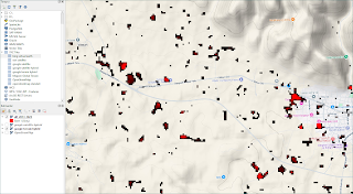
You can evaluate as very functional with rasterio differentiation of landcover
Not only for some organisational and administrative structures changing of landcover but also important as a pre-informaion based on needs of some geofirms.Where,I present easy but very useful a solution inccordancewith capabilities of rasterio;
I)Dataprocessing Step:
II)LandcoverChange Step:
Conclusions with some map templates via qgis of differentiation;
Note:
Some maptemplate informations for XYZ Tiles;
https://drive.google.com/file/d/1F6sIkUJHTbuF-43ZdUPOslrEMd1W2SGt/view?usp=sharing
Data:
https://drive.google.com/file/d/1cotdvGm-kkB8VZMKrtBBBsg5CLAL0-bw/view?usp=sharing
Ekrem ERKUŞ
Geophysics Engineer/TURKEY


Yorumlar
Yorum Gönder