I especially sign to role of wave penetration tests as Geophysics Ground Etudes from surface for weird ground regions effected of seismic shock waves
You know that I informed via MeWe platform about weird seismic conditions;


II


And next,my detailed evaluations concluded about a systematic development structure via Blagoevgrad Region based on Anapa Seismic Event;
Where,you will evaluate that as a extraordinary condition for Romania region(Thus,I am not knowing about more detailed causes).
Also,you know that I shared about ground conditions with some source mechanisms based on anticline and syncline models;
https://mybloginfrmtns.blogspot.com/2020/03/shaking-phenomena-caused-of-events.html?m=1
Thus,as a whole,I summaried as schematic about systematic development mechnanism of actual condition;

This table is extremely important.Because,understanding clear information about how handling to Geophysics Ground Etudes considered for weird ground regions!!!!This table with other informations into blog that clearly sign about inverse velocity model nature progressed based on surface source of Radar Technic for solution of inverse velocity structure based on source at weird ground regions......Thus,as Geophysicists,we especially express about role of Radar Penetration Tests from surface for this type weird ground regions.Our maximum penetration depth conclusions for this type weird ground region express as stronger locations of region!!!
Again I express that Penetration Tests based on Radar for Geophysics Ground Etudes handled at this type ground regions are among base points.
I will wait for replies of especially Geophysicists
Ekrem Erkuş
Geophysics Engineer
You know that I am following as actual about weird ground regions...
https://mybloginfrmtns.blogspot.com/2020/01/latest-earthquakes-showed-to.html?m=1
https://mybloginfrmtns.blogspot.com/2020/02/notei-continues-from-this-link-due-to.html?m=1
(Note.This determinations are expressing as conclusion of a pre-filtration by some evaluations.Thus,you will evaluate that sensitivity as 100% is not naturally subject.But,I can summary about 'very high trueness condition' considered for region descriptions...Thus,you will evaluate that weird ground region informations under this type blog sharings express as especially suggested regions for penetration depth tests from surface as Geophysics Ground Etudes!!!)
In the other hand,you will evaluate that serious region under similar ground structure at World is subject!!!!!!So,I harshly suggest for my weird region sharings via blogs.I think that thus as a supply for etude applications required at this type regions
A lighting for chapter as more clear(with a comparison):

Presentation-wave propagation condition as underground sourced.Where,signing to reverse condition of velocity column by knowed velocity nature(So,velocity increment condition to upper zone from lower zone of ground)
We understand using a "reverse progressed technic" among Geophysics Methods for wave penetration from surface against such a ground condition!!!(As knowed,radar technic is summarying wave propagation by gradient as low velocity for deep region with high velocity from surface);

You are right!!!Role of Radar Penetration Tests for Geophysics Etude of upper zone against such a ground structure thus explaining!!!
Thanks for your attention
Ekrem Erkuş
Geophysics Engineer
By the way,I establish explanation on a comparison based on structure...
You know some literature informations...So, Lacustrinal environments based on morphology have to high plasticity values.In the other hand,some articles as supplementary for this condition;


Also,you know from literature that relation condition based on penetration depth among plasticity characteristics with water content of a structure!!!In this mean,publish as a supplementary;

So,I summary that
High Plasticity structures(for example clays or Lacustrine environments as morphology) that causing to" high propagation characteristics "based on penetration depth from surface with a increment condition of water content based on ingredent !!!!
In this mean,you will conclude that low plasticity structures(for example,clays or fluvial environments as morphology) are causing to" high propagation characteristics "based on penetration depth from surface with a decreasing condition of water content based on ingredent.
Weird Ground Conditions are not static a structure...Transforming on Morphologic Environments with dynamism of Groundwater Level!!!
Weird ground conditions determined for your settlement province are not expressing a condition under same static structure as continuos...In this mean,I prepared a explanatory presentation;

Where,shortly you will see that a periodicity condition by Groundwater level Dynamism for Lacustral and Fluvial Morphologic Environments which very very critic!!!Also,again you will see that about caused to how a development for layers based on morphologic environments of this dynamism(summaried via arrows).Yes,you are right!!!I mean that signing to extreme condition based on plasticity for upper zone with a movement nature as similar direction of layers by periodicity.
As summary,sign to Penetration depth tests for chapters as reliable settlement issues based on
- Fluvial Morphology Environment or low plasticity structure regions under decreasing contion of Groundwater level
- Lacustral Morphology Environment or high plasticity structure regions under increasing condition of Groundwater level
Also,this type tests are establishing a solution for ground stability problems as landslides caused of shaking effects
This blog is quite productive(especially; researchers,appliers and system developers that among my first focal targets)...Thus again thanks
I hope that Why about established of different type conclusions at deposit environments countered to similar type dynamism based on groundwater levels.Or inversely,about established of similar type conclusions for deposit environments encountered to groundwater level dynamisms based on different type
In this conclusions,As other grove of condition knowed as literature I framed about explanation of weird behaviour of Ground;

Application:
I carried-out a application example...Where,I accepted that about evaluated of some pre-studies.Thus,for example,two section created by evaluation at two region;


For example,presentations based on application of a radar penetration test projected for upper region among this sections;


So,thus we can summary as example of a projected application...
Especially,I predict a question mark about mechanism for Fluvial Morphology Environments(low plasticity conditions) by decreasing condition of Groundwater level.Note.You will evaluate that I have not considered for sub-classification chapter.So,for example,a morphology as Glaciofluvial Environment is sub-classification of Fluvial Environment...
I sure that some followers have to problematic a condition about mechanism expressed.Thus,I summary for condition as more detailed;

You are right!!!Understanding a "maximum horizontal transmission condition!!!!!!!" as a conclusion of lowest plasticity characteristics for upper zone by considering of decreasing condition of Groundwater.By this weird condition ,I conclude about a antropogenic condition.Because,horizontal transmission under such a lowest plasticity condition must be minimum!!!!!!As conclusion,evaluating as effect of pulling under such condition of Groundwater
Again thanks...This chapter is among maybe most serious headlines into indirect effects caused of Earthquakes.And,as supplementary with reports,expressing as "most serious ground problem" based on dynamism by Wordscale!!! I know thus about great efforts of especially EMSC Seismologists.You remember that I realised information as a supplementary to public into this field;
A fix determination based on latest presentation...With this model,I detailed by two fluvial morphology;
Where,you will evaluate as more clear about velocity contrast condition!!!So,I especially underline about a "selective velocity contrast" for groundwater pulling zone by decreasing phase of groundwater level.Again you evaluate that shaking effects caused of a far source by this condition is not only plainal type geographies but also establishing same conclusions for topographic geophraphies
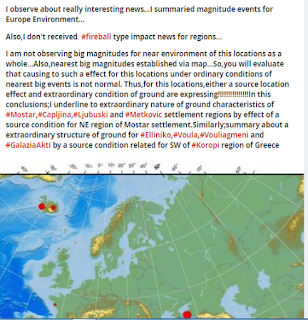
Some questions about Earthquake producing potential as single of this type events by mechanism are naturally understanding...I summary about condition with actual a news as very interesting;
I took a "Seismic Event" information as very weird based on Seismologic from Turkey;

Expressing active structures based on historic as "Deysan and Cüllub " rivers at this region...So,region has to fluival morphology.Thus,evaluating caused to Seismic Events as a conclusion under similar type mechanism of region of Harran Region Earthquakes as evaluated with latest section
I present a example applied for logic of Penetration Tests from Surface;
Thus,I think about understood as clearer of chapter...This example shortly means about description of collapsed region for zone of deepest penetration gradient by determined line.You are right!!!highest penetration depth gradients of determined lines based on similar technic evaluate as our critic locations
Thus,fixed chapter about how a penetration profile after major region determination for a risk zone;

Presentation-A profile example at risk zone determination
If you establish other profiling as orthogonal via a point as origin,handling information qualified about a collapse zone with similar patern conlusion!!!So,this principle can summary as profiling strategy as second step
I informed about DPR system of LOZA as literature...And thus,I realised a routine check about latest developments.A PDF summary of EMIW 2018 Workshop that very interesting as informations;
LOZA has to systems developed based on deep radar penetrations.And,I carried-out a comparison about my latest presentation with "Kimberlite Pipe in Australia" example into this presentation;

Yes...In this mean,I established "a description about penetration" by our concept.Where,you clearly understand that Kimberlite pipe structure region is expressing as max.depth of penetration!!!And next,where,you see a level as 200 m as horizon!!!
Thus,this GPR system that I noted among most applicable solutions on our project concept
I compiled some selective examples based on our aim;

Mid field-Presenting a deep penetration nature(Note.I am not knowing about main aim at this region)
By the way,real condition is summarying about intrusive nature from limestone at Chojnice region.So,summarying a condition into big corelation to our concept...Thus,A page established access via link to examples detailed with related pdf(Chojnice);

Another example is informing as clear about zone of max. penetration thickness by two profile. Where,expressing a condition based on evaluation of a max.penetration condition for right zone region by our concept
a evaluation example into our concept....Where,you can think that Water Saturation Zones are as lowest zones by Penetration thickness.So,this regions are expressing as most powerful locations against shaking effects caused of Earthquakes...In this mean,Deep Penetrated Zones are more prone agains this type effects(Note.depth range is 250 m!!!)


Another deep penetration example by our concept.Thus,You will evaluate about a weird velocity contrast for left part!!!(Because,penetration depth is developing serious degree at left part).Where, really subject role of a antropogenic effect!!!(Link expresses summary about a comparison of ROTEG GPR and LOZA-N GPR with a borehole condition!!!);
I share a perfect presentation prepared on multigeologic aims about system(where,also,you will inform about cause of some conditions based on our concept);
A effective presentation about Li-Pegmatites based on Intrusive-Penetrative developments(Thus,I especially wonder that about sensing against shaking effects of region based on Penetrative zones😏.Thus,I think that about a good "Geophysics researching Letter" information for Geophysics Community👌.So,I especially underline that thus about carrying-out of a important literature application👍👍👍);
#SOME VIDEO PRESENTATIONS FOR INFORMING ABOUT SYSTEM CAPABILITIES#
La aplicacion del Georadar GPR(radar de penetracion terrestre) <LOZA> durante la revelacion Y cartografia de las fallas geologicas;
You know that evaluating for bed conditions due to some chapters of Freshwater environments is extremely important
A Radar Application about Bed scaning of Freshwater environments;
Note.By the way,subject information about running capabilities for Saltwater environments!!! of related LOZA systems!!!(Really very very interesting)
In this blog,I especially concentrated for shaking effects caused of a far Earthquake.Naturally,You will see that I framed about examples based on Intrusive-Penetrative relations via considering to Geologic Structure Columns of Radar...Thus,We can produce good conclusions for geophysics ground etudes by seismologic concept as evaluated into Li-Pegmatite example!!!So,I mean that not only for geophysics ground etudes of DPR but also about good indicators established for important different chapters during different aims as mining field😏.Thus,I especially underline about role of this blog for followers!!!
I can express about perfect evaluation condition for our concept on radar section of a "sand quarry profile"!!!Thus,you inform as clear about caused to shaking effects of a far earthquake of how type mechanisms;
Important Note.Where,as maybe most important,you must consider for conditions expressed with decreasing condition of GW Level
----------------------------------------------------------------------------------------------------------------
By the way,amazing penetration characteristics by depth of profile sections handled based on Mining thus causing as a big supplementary information for settlements!!!In this mean,you will remember that I established information on a Li-Pegmatite example...Similarly, Kimberlite Pipe example at upper part of blogger is summary about such a structure.Where,you will evaluate that we can express about nature as shaking prone by penetration characteristics of Kimberlite Pipe Zone(Again,I think about a good information for researchers).
"Next Generation Deep
Penetrating Ground Radar for
Mineral Exploration"_detailed presentation;
Also,a presentation about role of Radar Penetration at temperature envrionments that you will inform about how a role of temperature;
Application of electronic systems of georadical surface sensing
this blog shortly " a reflection of ever that my individual information background ".And,I realised a nice summary for various person/organisation via a presentation;
Again thanks...Ekrem
You know that high humidity conditions of ground are other big calamity for settlements...In this mean,I sign to high penetrative nature of humidity based on radar.Yes,you are right!!!another performance of high penetrative zones with radar that establishing very clear paterns for this type humidity zone👍So,another problem condition based on settlements of high penetrative zones that supplying/confirming by high penetrative thesis!!!(So,thus,dangerous condition for settlements of high penetrative zones is again understanding)Also,you know that effect to structure systems of this humidity conditions is plus disadvantage!!!
two example evaluated about this chapter;
I think that some chapters are more clear!!!Link of nice pdf document about presentations;
Again special thanks...Where,I shortly present about a reflection as detailed of my experiments for related environments.Thus,you naturally will evaluate that this condition among my aim tasks👍
And next,important chapter into other dense speculated fields is about risk condition caused of karstic regions.....Thus,I will establish a lighting for communities with my individual experiments.In this aim,firstly I expressed a presentation;

You are right!!!I mean that We must have to qualified "deep penetrated information" at zone region for a hazard condition of a karstic structure region!!!(Note.Subject some informations about this qualified information based on presentations into blog).Again you are right!!!If we can catch some indicators about deep penetrated nature related between void patern-upper zone by sections,this condition is absolutely expressing a hazard condition for karstic region!For another condition,I suggest about periodic a inspection procedure via deep penetration tests(as a fixing about characteristics by longtime frame of Zone).
Condition about Karstic regions thus explained.Shortly,I mean that a problem condition for all karstic morphology regions is not subject...Even if there extreme void environment as a underground river in your settlement province, there are not any problems by non-penetrative patern conditions for mid-zone at DPR
By the way,actual news;
https://youtu.be/3IJOYhYibeQ
EVALUATION:
I think about big supplies of GRACE-FO satellite missioned as last year-referenced on serious 'water decreasing and increasing conditions' by seasonal scale
In the other hand,I must emphasize to performance about role for headlines as Exploration,Geotechnical Engineering,Hydrogeology and Archaeology of LOZA GPR SYSTEM;


I


Part as related to Hydrogeology presented on blog information;


By the way,there is a video information on Archaeologic concept of Loza System as actual(Note.no any translation option as language.Thus,I evaluate on measurement profile informations as orthogonal¶llel to fortress column that a "Geotechnic Inspection Scanning" is understanding as big possibility.Summarying as example the structure weakness caused of intrusive effects as water or humidity as similar to dam example among biggest geotechnic problems for structure columns as fortress);
Expressing Roteg GPR as other selective element of Deep GPR concept. For interesting article information;
By the way, I interest to presentation example considered for a Apatite Hill;

Especially,subject serious effects caused of some seismic events at cavity type formation regions.Thus,example will produce a sense about caused how effects considering regional geology of some cavity systems;


.PNG)


Yorumlar
Yorum Gönder