A methodology of establishing to Transform type locations with Google Earth
How understanding to transform a type location on a explosive volcano information?
Manam Volcano that a important island volcano of Pupua-New Guinea Region.This volcano is not eruptive.Explosive style a volcano!!!expressing as collision boundary of Australia plate with Pasific plate at Bismarc Sea Region...Latest important development is as last Aug(2018).
A 10000km radius analysis on this location shows that famous Mendonico Fault.Next,Considering to analysis on circle line of second explosive style volcano via 6000km triangulation method.Thus,catching to transform type strcuture by this line analysis(experience)!!!
Manam Volcano coordinate;
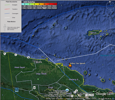

Analysis on 10000km(White circle) from this point express that as clear is not a explosive volcanism.Thus,confirmation methodology to established location on experiments for a underwater volcanism thus,will be complementary


Yellow line express that Kamchatka as a 10000kmradius.So,a famous swarm location;
Shortly,this swarm that expressing to this underwater volcanism as 10000km distance
After confirmation,A information about shape of famous Mendonico Transform on whitecircle;
By the way,special thanks for Plate Boundaries.KML aplication...Experts know that transform type structures have to clear indicating as morphologic.For example,as Mendonico Transform.This informations that to catching to transform a type structure on analysis for redcircle will cause;
And,conclusion
Kunya-Urgench region with clear indicator as Geomorphologic is identifying...
.PNG)


Yorumlar
Yorum Gönder