RASTER PROCESSING USING PYTHON TOOLS
import rasterio
import rasterio.plot
import pyproj
import numpy as np
import matplotlib
import matplotlib.pyplot as plt
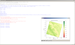
print('Landsat on AWS:')
filepath = 'http://landsat-pds.s3.amazonaws.com/c1/L8/042/034/LC08_L1TP_042034_20170616_20170629_01_T1/LC08_L1TP_042034_20170616_20170629_01_T1_B4.TIF'
with rasterio.open(filepath) as src:
print(src.profile)
# The grid of raster values can be accessed as a numpy array and plotted:
with rasterio.open(filepath) as src:
oviews = src.overviews(1) # list of overviews from biggest to smallest
oview = oviews[-1] # let's look at the smallest thumbnail
print('Decimation factor= {}'.format(oview))
# NOTE this is using a 'decimated read' (http://rasterio.readthedocs.io/en/latest/topics/resampling.html)
thumbnail = src.read(1, out_shape=(1, int(src.height // oview), int(src.width // oview)))
print('array type: ',type(thumbnail))
print(thumbnail)
plt.imshow(thumbnail)
plt.colorbar()
plt.title('Overview - Band 4 {}'.format(thumbnail.shape))
plt.xlabel('Column #')
plt.ylabel('Row #')
plt.show()
with rasterio.open(filepath) as src:
oviews = src.overviews(1)
oview = oviews[-1]
print('Decimation factor= {}'.format(oview))
thumbnail = src.read(1, out_shape=(1, int(src.height // oview), int(src.width // oview)))
thumbnail = thumbnail.astype('f4')
thumbnail[thumbnail==0] = np.nan
plt.imshow(thumbnail)
plt.colorbar()
plt.title('Overview - Band 4 {}'.format(thumbnail.shape))
plt.xlabel('Column #')
plt.ylabel('Row #')
plt.show()
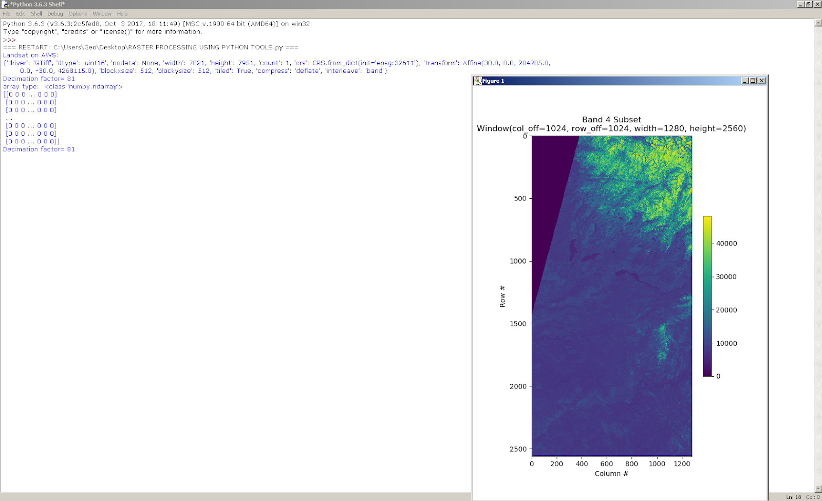
#https://rasterio.readthedocs.io/en/latest/topics/windowed-rw.html
#rasterio.windows.Window(col_off, row_off, width, height)
window = rasterio.windows.Window(1024, 1024, 1280, 2560)
with rasterio.open(filepath) as src:
subset = src.read(1, window=window)
plt.figure(figsize=(6,8.5))
plt.imshow(subset)
plt.colorbar(shrink=0.5)
plt.title(f'Band 4 Subset\n{window}')
plt.xlabel('Column #')
plt.ylabel('Row #')
plt.show()
# Use the same example image:
date = '2017-06-16'
url = 'http://landsat-pds.s3.amazonaws.com/c1/L8/042/034/LC08_L1TP_042034_20170616_20170629_01_T1/'
redband = 'LC08_L1TP_042034_20170616_20170629_01_T1_B{}.TIF'.format(4)
nirband = 'LC08_L1TP_042034_20170616_20170629_01_T1_B{}.TIF'.format(5)
with rasterio.open(url+redband) as src:
profile = src.profile
oviews = src.overviews(1) # list of overviews from biggest to smallest
oview = oviews[1] # Use second-highest resolution overview
print('Decimation factor= {}'.format(oview))
red = src.read(1, out_shape=(1, int(src.height // oview), int(src.width // oview)))
plt.imshow(red)
plt.colorbar()
plt.title('{}\nRed {}'.format(redband, red.shape))
plt.xlabel('Column #')
plt.ylabel('Row #')
plt.show()
filepath=url+nirband
with rasterio.open(filepath) as src:
print('Opening:', filepath)
oviews = src.overviews(1) # list of overviews from biggest to smallest
oview = oviews[1] # Use second-highest resolution overview
print('Decimation factor= {}'.format(oview))
nir = src.read(1, out_shape=(1, int(src.height // oview), int(src.width // oview)))
def calc_ndvi(nir,red):
'''Calculate NDVI from integer arrays'''
nir = nir.astype('f4')
red = red.astype('f4')
ndvi = (nir - red) *(1./(nir + red))
print(ndvi)
return ndvi
ndvi = calc_ndvi(nir,red)
plt.imshow(ndvi, cmap='RdYlGn')
plt.colorbar()
plt.title('NDVI {}'.format(date))
plt.xlabel('Column #')
plt.ylabel('Row #')
plt.show()
localname = 'LC08_L1TP_042034_20170616_20170629_01_T1_NDVI_OVIEW.tif'
with rasterio.open(url+nirband) as src:
profile = src.profile.copy()
aff = src.transform
newaff = rasterio.Affine(aff.a * oview, aff.b, aff.c,
aff.d, aff.e * oview, aff.f)
profile.update({
'dtype': 'float32',
'height': ndvi.shape[0],
'width': ndvi.shape[1],
'transform': newaff})
with rasterio.open(localname, 'w', **profile) as dst:
dst.write_band(1, ndvi)
# Use the same example image:
date2 = '2018-06-19'
url2 = 'http://landsat-pds.s3.amazonaws.com/c1/L8/042/034/LC08_L1TP_042034_20180619_20180703_01_T1/'
redband2 = 'LC08_L1TP_042034_20180619_20180703_01_T1_B{}.TIF'.format(4)
nirband2 = 'LC08_L1TP_042034_20180619_20180703_01_T1_B{}.TIF'.format(5)
with rasterio.open(url2+nirband2) as src:
oviews = src.overviews(1) # list of overviews from biggest to smallest
oview = oviews[1] # Use second-highest resolution overview
print('Decimation factor= {}'.format(oview))
red2 = src.read(1, out_shape=(1, int(src.height // oview), int(src.width // oview)))
plt.imshow(red2)
plt.colorbar()
plt.title('{}\nRed {}'.format(redband2, red.shape))
plt.xlabel('Column #')
plt.ylabel('Row #')
plt.show()
filepath = url2+nirband2
with rasterio.open(filepath) as src:
print('Opening:', filepath)
oviews = src.overviews(1) # list of overviews from biggest to smallest
oview = oviews[1] # Use second-highest resolution overview
print('Decimation factor= {}'.format(oview))
nir2 = src.read(1, out_shape=(1, int(src.height // oview), int(src.width // oview)))
def x(nir2,red2):
'''Calculate NDVI from integer arrays'''
nir = nir2.astype('f4')
red = red2.astype('f4')
ndvi2 = (nir - red) * (1./(nir + red))
print(ndvi2)
return ndvi2
ndvi2 = x(nir2,red2)
plt.imshow(ndvi2, cmap='RdYlGn')
plt.colorbar()
plt.title('NDVI {}'.format(date2))
plt.xlabel('Column #')
plt.ylabel('Row #')
plt.show()
localname = 'LC08_L1TP_042034_20180619_20180703_01_T1_NDVI_OVIEW.tif'
with rasterio.open(url+nirband) as src:
profile = src.profile.copy()
aff = src.transform
newaff = rasterio.Affine(aff.a * oview, aff.b, aff.c,
aff.d, aff.e * oview, aff.f)
profile.update({
'dtype': 'float32',
'height': ndvi.shape[0],
'width': ndvi.shape[1],
'transform': newaff})
with rasterio.open(localname, 'w', **profile) as dst:
dst.write_band(1, ndvi)
fig, axes = plt.subplots(1,3, figsize=(14,6), sharex=True, sharey=True)
plt.sca(axes[0])
plt.imshow(ndvi, cmap='RdYlGn', vmin=-1, vmax=1)
plt.colorbar(shrink=0.5)
plt.title('NDVI {}'.format(date))
plt.xlabel('Column #')
plt.ylabel('Row #')
plt.sca(axes[1])
plt.imshow(ndvi2, cmap='RdYlGn', vmin=-1, vmax=1)
plt.colorbar(shrink=0.5)
plt.title('NDVI {}'.format(date2))
plt.sca(axes[2])
plt.imshow(ndvi2 - ndvi, cmap='bwr', vmin=-1, vmax=1)
plt.colorbar(shrink=0.5)
plt.title('Diff ({} - {})'.format(date2, date))
plt.show()
localname = 'LC08_L1TP_042034_20170616_20170629_01_T1_NDVI_OVIEW.tif'
date = '2017-06-16'
# Reopen the file and plot
with rasterio.open(localname) as src:
print(src.profile)
ndvi = src.read(1) # read the entire array
plt.imshow(ndvi, cmap='RdYlGn')
plt.colorbar()
plt.title('NDVI {}'.format(date))
plt.xlabel('Column #')
plt.ylabel('Row #')
plt.show()
# in this case, coordinates are Easting [m] and Northing [m], and colorbar is default instead of RdYlGn
with rasterio.open(localname) as src:
fig, ax = plt.subplots()
rasterio.plot.show(src, ax=ax, title='NDVI')
plt.show()
with rasterio.open(localname) as src:
# Use pyproj to convert point coordinates
utm = pyproj.Proj(src.crs) # Pass CRS of image from rasterio
lonlat = pyproj.Proj(init='epsg:4326')
lon,lat = (-119.770163586, 36.741997032)
east,north = pyproj.transform(lonlat, utm, lon, lat)
print('Fresno NDVI\n-------')
print(f'lon,lat=\t\t({lon:.2f},{lat:.2f})')
print(f'easting,northing=\t({east:g},{north:g})')
# What is the corresponding row and column in our image?
row, col = src.index(east, north) # spatial --> image coordinates
print(f'row,col=\t\t({row},{col})')
# What is the NDVI?
value = ndvi[row, col]
print(f'ndvi=\t\t\t{value:.2f}')
# Or if you see an interesting feature and want to know the spatial coordinates:
row, col = 200, 450
east, north = src.xy(row,col) # image --> spatial coordinates
on,lat = pyproj.transform(utm, lonlat, east, north)
value = ndvi[row, col]
print(f'''
Interesting Feature
-------
row,col= ({row},{col})
easting,northing= ({east:g},{north:g})
lon,lat= ({lon:.2f},{lat:.2f})
ndvi= {value:.2f}
''')
#WGS84 NDVI(2017 IMAGE)
import rasterio.warp
import rasterio.shutil
localname = 'LC08_L1TP_042034_20170616_20170629_01_T1_NDVI_OVIEW.tif'
vrtname = 'LC08_L1TP_042034_20170616_20170629_01_T1_NDVI_OVIEW_WGS84.vrt'
with rasterio.open(localname) as src:
with rasterio.vrt.WarpedVRT(src, crs='epsg:4326', resampling=rasterio.enums.Resampling.bilinear) as vrt:
rasterio.shutil.copy(vrt, vrtname, driver='VRT')
# Open the local warped file and plot
# NOTE our coordinates have changed to lat, lon. we should probably crop the edge artifacts do to reprojection too!
with rasterio.open(vrtname) as src:
rasterio.plot.show(src, title='NDVI', cmap='RdYlGn', vmin=-1, vmax=1)
#WGS84 GRAYSCALE(2017 IMAGE)
localname = 'LC08_L1TP_042034_20170616_20170629_01_T1_NDVI_OVIEW.tif'
tifname = 'LC08_L1TP_042034_20170616_20170629_01_T1_NDVI_OVIEW_WGS84.tif'
dst_crs = 'EPSG:4326'
with rasterio.open(localname) as src:
profile = src.profile.copy()
transform, width, height = rasterio.warp.calculate_default_transform(
src.crs, dst_crs, src.width, src.height, *src.bounds)
profile.update({
'crs': dst_crs,
'transform': transform,
'width': width,
'height': height
})
with rasterio.open(tifname, 'w', **profile) as dst:
rasterio.warp.reproject(
source=rasterio.band(src, 1),
destination=rasterio.band(dst, 1),
src_transform=src.transform,
src_crs=src.crs,
dst_transform=transform,
dst_crs=dst_crs,
resampling=rasterio.warp.Resampling.bilinear)
Snapshot conclusions during compiling;


import rasterio.plot
import pyproj
import numpy as np
import matplotlib
import matplotlib.pyplot as plt
print('Landsat on AWS:')
filepath = 'http://landsat-pds.s3.amazonaws.com/c1/L8/042/034/LC08_L1TP_042034_20170616_20170629_01_T1/LC08_L1TP_042034_20170616_20170629_01_T1_B4.TIF'
with rasterio.open(filepath) as src:
print(src.profile)
# The grid of raster values can be accessed as a numpy array and plotted:
with rasterio.open(filepath) as src:
oviews = src.overviews(1) # list of overviews from biggest to smallest
oview = oviews[-1] # let's look at the smallest thumbnail
print('Decimation factor= {}'.format(oview))
# NOTE this is using a 'decimated read' (http://rasterio.readthedocs.io/en/latest/topics/resampling.html)
thumbnail = src.read(1, out_shape=(1, int(src.height // oview), int(src.width // oview)))
print('array type: ',type(thumbnail))
print(thumbnail)
plt.imshow(thumbnail)
plt.colorbar()
plt.title('Overview - Band 4 {}'.format(thumbnail.shape))
plt.xlabel('Column #')
plt.ylabel('Row #')
plt.show()
with rasterio.open(filepath) as src:
oviews = src.overviews(1)
oview = oviews[-1]
print('Decimation factor= {}'.format(oview))
thumbnail = src.read(1, out_shape=(1, int(src.height // oview), int(src.width // oview)))
thumbnail = thumbnail.astype('f4')
thumbnail[thumbnail==0] = np.nan
plt.imshow(thumbnail)
plt.colorbar()
plt.title('Overview - Band 4 {}'.format(thumbnail.shape))
plt.xlabel('Column #')
plt.ylabel('Row #')
plt.show()
#https://rasterio.readthedocs.io/en/latest/topics/windowed-rw.html
#rasterio.windows.Window(col_off, row_off, width, height)
window = rasterio.windows.Window(1024, 1024, 1280, 2560)
with rasterio.open(filepath) as src:
subset = src.read(1, window=window)
plt.figure(figsize=(6,8.5))
plt.imshow(subset)
plt.colorbar(shrink=0.5)
plt.title(f'Band 4 Subset\n{window}')
plt.xlabel('Column #')
plt.ylabel('Row #')
plt.show()
# Use the same example image:
date = '2017-06-16'
url = 'http://landsat-pds.s3.amazonaws.com/c1/L8/042/034/LC08_L1TP_042034_20170616_20170629_01_T1/'
redband = 'LC08_L1TP_042034_20170616_20170629_01_T1_B{}.TIF'.format(4)
nirband = 'LC08_L1TP_042034_20170616_20170629_01_T1_B{}.TIF'.format(5)
with rasterio.open(url+redband) as src:
profile = src.profile
oviews = src.overviews(1) # list of overviews from biggest to smallest
oview = oviews[1] # Use second-highest resolution overview
print('Decimation factor= {}'.format(oview))
red = src.read(1, out_shape=(1, int(src.height // oview), int(src.width // oview)))
plt.imshow(red)
plt.colorbar()
plt.title('{}\nRed {}'.format(redband, red.shape))
plt.xlabel('Column #')
plt.ylabel('Row #')
plt.show()
filepath=url+nirband
with rasterio.open(filepath) as src:
print('Opening:', filepath)
oviews = src.overviews(1) # list of overviews from biggest to smallest
oview = oviews[1] # Use second-highest resolution overview
print('Decimation factor= {}'.format(oview))
nir = src.read(1, out_shape=(1, int(src.height // oview), int(src.width // oview)))
def calc_ndvi(nir,red):
'''Calculate NDVI from integer arrays'''
nir = nir.astype('f4')
red = red.astype('f4')
ndvi = (nir - red) *(1./(nir + red))
print(ndvi)
return ndvi
ndvi = calc_ndvi(nir,red)
plt.imshow(ndvi, cmap='RdYlGn')
plt.colorbar()
plt.title('NDVI {}'.format(date))
plt.xlabel('Column #')
plt.ylabel('Row #')
plt.show()
localname = 'LC08_L1TP_042034_20170616_20170629_01_T1_NDVI_OVIEW.tif'
with rasterio.open(url+nirband) as src:
profile = src.profile.copy()
aff = src.transform
newaff = rasterio.Affine(aff.a * oview, aff.b, aff.c,
aff.d, aff.e * oview, aff.f)
profile.update({
'dtype': 'float32',
'height': ndvi.shape[0],
'width': ndvi.shape[1],
'transform': newaff})
with rasterio.open(localname, 'w', **profile) as dst:
dst.write_band(1, ndvi)
# Use the same example image:
date2 = '2018-06-19'
url2 = 'http://landsat-pds.s3.amazonaws.com/c1/L8/042/034/LC08_L1TP_042034_20180619_20180703_01_T1/'
redband2 = 'LC08_L1TP_042034_20180619_20180703_01_T1_B{}.TIF'.format(4)
nirband2 = 'LC08_L1TP_042034_20180619_20180703_01_T1_B{}.TIF'.format(5)
with rasterio.open(url2+nirband2) as src:
oviews = src.overviews(1) # list of overviews from biggest to smallest
oview = oviews[1] # Use second-highest resolution overview
print('Decimation factor= {}'.format(oview))
red2 = src.read(1, out_shape=(1, int(src.height // oview), int(src.width // oview)))
plt.imshow(red2)
plt.colorbar()
plt.title('{}\nRed {}'.format(redband2, red.shape))
plt.xlabel('Column #')
plt.ylabel('Row #')
plt.show()
filepath = url2+nirband2
with rasterio.open(filepath) as src:
print('Opening:', filepath)
oviews = src.overviews(1) # list of overviews from biggest to smallest
oview = oviews[1] # Use second-highest resolution overview
print('Decimation factor= {}'.format(oview))
nir2 = src.read(1, out_shape=(1, int(src.height // oview), int(src.width // oview)))
def x(nir2,red2):
'''Calculate NDVI from integer arrays'''
nir = nir2.astype('f4')
red = red2.astype('f4')
ndvi2 = (nir - red) * (1./(nir + red))
print(ndvi2)
return ndvi2
ndvi2 = x(nir2,red2)
plt.imshow(ndvi2, cmap='RdYlGn')
plt.colorbar()
plt.title('NDVI {}'.format(date2))
plt.xlabel('Column #')
plt.ylabel('Row #')
plt.show()
localname = 'LC08_L1TP_042034_20180619_20180703_01_T1_NDVI_OVIEW.tif'
with rasterio.open(url+nirband) as src:
profile = src.profile.copy()
aff = src.transform
newaff = rasterio.Affine(aff.a * oview, aff.b, aff.c,
aff.d, aff.e * oview, aff.f)
profile.update({
'dtype': 'float32',
'height': ndvi.shape[0],
'width': ndvi.shape[1],
'transform': newaff})
with rasterio.open(localname, 'w', **profile) as dst:
dst.write_band(1, ndvi)
fig, axes = plt.subplots(1,3, figsize=(14,6), sharex=True, sharey=True)
plt.sca(axes[0])
plt.imshow(ndvi, cmap='RdYlGn', vmin=-1, vmax=1)
plt.colorbar(shrink=0.5)
plt.title('NDVI {}'.format(date))
plt.xlabel('Column #')
plt.ylabel('Row #')
plt.sca(axes[1])
plt.imshow(ndvi2, cmap='RdYlGn', vmin=-1, vmax=1)
plt.colorbar(shrink=0.5)
plt.title('NDVI {}'.format(date2))
plt.sca(axes[2])
plt.imshow(ndvi2 - ndvi, cmap='bwr', vmin=-1, vmax=1)
plt.colorbar(shrink=0.5)
plt.title('Diff ({} - {})'.format(date2, date))
plt.show()
localname = 'LC08_L1TP_042034_20170616_20170629_01_T1_NDVI_OVIEW.tif'
date = '2017-06-16'
# Reopen the file and plot
with rasterio.open(localname) as src:
print(src.profile)
ndvi = src.read(1) # read the entire array
plt.imshow(ndvi, cmap='RdYlGn')
plt.colorbar()
plt.title('NDVI {}'.format(date))
plt.xlabel('Column #')
plt.ylabel('Row #')
plt.show()
# in this case, coordinates are Easting [m] and Northing [m], and colorbar is default instead of RdYlGn
with rasterio.open(localname) as src:
fig, ax = plt.subplots()
rasterio.plot.show(src, ax=ax, title='NDVI')
plt.show()
with rasterio.open(localname) as src:
# Use pyproj to convert point coordinates
utm = pyproj.Proj(src.crs) # Pass CRS of image from rasterio
lonlat = pyproj.Proj(init='epsg:4326')
lon,lat = (-119.770163586, 36.741997032)
east,north = pyproj.transform(lonlat, utm, lon, lat)
print('Fresno NDVI\n-------')
print(f'lon,lat=\t\t({lon:.2f},{lat:.2f})')
print(f'easting,northing=\t({east:g},{north:g})')
# What is the corresponding row and column in our image?
row, col = src.index(east, north) # spatial --> image coordinates
print(f'row,col=\t\t({row},{col})')
# What is the NDVI?
value = ndvi[row, col]
print(f'ndvi=\t\t\t{value:.2f}')
# Or if you see an interesting feature and want to know the spatial coordinates:
row, col = 200, 450
east, north = src.xy(row,col) # image --> spatial coordinates
on,lat = pyproj.transform(utm, lonlat, east, north)
value = ndvi[row, col]
print(f'''
Interesting Feature
-------
row,col= ({row},{col})
easting,northing= ({east:g},{north:g})
lon,lat= ({lon:.2f},{lat:.2f})
ndvi= {value:.2f}
''')
#WGS84 NDVI(2017 IMAGE)
import rasterio.warp
import rasterio.shutil
localname = 'LC08_L1TP_042034_20170616_20170629_01_T1_NDVI_OVIEW.tif'
vrtname = 'LC08_L1TP_042034_20170616_20170629_01_T1_NDVI_OVIEW_WGS84.vrt'
with rasterio.open(localname) as src:
with rasterio.vrt.WarpedVRT(src, crs='epsg:4326', resampling=rasterio.enums.Resampling.bilinear) as vrt:
rasterio.shutil.copy(vrt, vrtname, driver='VRT')
# Open the local warped file and plot
# NOTE our coordinates have changed to lat, lon. we should probably crop the edge artifacts do to reprojection too!
with rasterio.open(vrtname) as src:
rasterio.plot.show(src, title='NDVI', cmap='RdYlGn', vmin=-1, vmax=1)
#WGS84 GRAYSCALE(2017 IMAGE)
localname = 'LC08_L1TP_042034_20170616_20170629_01_T1_NDVI_OVIEW.tif'
tifname = 'LC08_L1TP_042034_20170616_20170629_01_T1_NDVI_OVIEW_WGS84.tif'
dst_crs = 'EPSG:4326'
with rasterio.open(localname) as src:
profile = src.profile.copy()
transform, width, height = rasterio.warp.calculate_default_transform(
src.crs, dst_crs, src.width, src.height, *src.bounds)
profile.update({
'crs': dst_crs,
'transform': transform,
'width': width,
'height': height
})
with rasterio.open(tifname, 'w', **profile) as dst:
rasterio.warp.reproject(
source=rasterio.band(src, 1),
destination=rasterio.band(dst, 1),
src_transform=src.transform,
src_crs=src.crs,
dst_transform=transform,
dst_crs=dst_crs,
resampling=rasterio.warp.Resampling.bilinear)
Snapshot conclusions during compiling;


By the way,produced files at your desktop;

1)grayscale tif files by two different date which can handle as a input file for some analysis as dem;
2)produced .vrt format* by date that you know role
3)And, grayscale tif file on produced WGS84 coordinate by date.( A file as other WGS84 coordinated is considering for NDVI image during compiling)

Yorumlar
Yorum Gönder