Kayıtlar

fiona etiketine sahip yayınlar gösteriliyor

How to interpolate geospatial points to contours with Python and GDAL

Resim
  Data Link: How to interpolate geospatial points to contours with Python and GDAL - Tutorial — Hatari Labs

Rasterio_cmap application based on RasterBand and BandZero

Resim
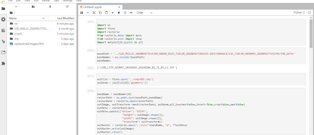
Rasterband  and BandZero application via Rasterio...Where,shortly,expresssed blues operation of cmap for parts related of rasterband conclusions with darkblue  at cmap spectral range related of bandzero conclusions...Where,I used tif and shp files as input data.Conclusion expresses on different formats under rst folder; Input data link:   https://www.hatarilabs.com/ih-en/how-to-clip-sentinel-2-bands-to-a-area-of-interest-with-python-rasterio-and-fiona-tutorial Where,I especially emphasize that about application of  a .tif file as different from .jp2 format  for target folder on bandpath. In the other hand,subject requirements  for compilation of some rasterio functions.For example,you must consider update procedures for rasterio module.And,I suggest sphinx installation on matters as restructuredtext files.

Geopandas installation for users

Resim
I know serious problems of users about Geopandas module installation!!!Thus,I will establish information about some critic installation tips.Fistly,I express that you must use Anaconda Prompt for all module installations!!!Where,I explained critic module procedures of first step; You are right!!!Subject some main and secondary modules for geopandas module on first step!And,critic some procedures for this modules clearly expressed on presentation.Next,answer of IPython console with compilation is successful👌 Second step require a procedure by different type syntax.Where,I summary role of again Anaconda Prompt. And next,I tested about applicability of geopandas module.Conclusion is successful;